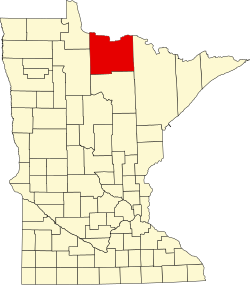
Birchdale | |
---|---|
Coordinates: 48°37′37″N94°06′07″W / 48.62694°N 94.10194°W | |
Country | United States |
State | Minnesota |
County | Koochiching |
Elevation | 1,165 ft (355 m) |
Time zone | UTC-6 (Central (CST)) |
• Summer (DST) | UTC-5 (CDT) |
ZIP code | 56623 or 56629 |
Area code | 218 |
GNIS feature ID | 640183 [1] |
Birchdale is an unincorporated community in Koochiching County, Minnesota, United States.
The community is located between International Falls and Baudette on State Highway 11 (MN 11), 42 miles west of International Falls and 26 miles east of Baudette, within Northwest Koochiching Unorganized Territory
Franz Jevne State Park and the Rainy River are both in the vicinity.
Popular events include the annual 4 July and Holiday Lights parades.
Channel | Callsign | Affiliation | Branding | Subchannels | Owner | |
---|---|---|---|---|---|---|
(Virtual) | Channel | Programming | ||||
9.1 | K35MY-D (KAWE Translator) | PBS | Lakeland PBS | 9.2 9.3 9.4 9.5 9.6 | First Nations Experience PBS Kids Create PBS Encore Minnesota Channel | County of Koochiching |
11.1 | K31PK-D (KRII Translator) | NBC | KBJR 6 | 11.2 11.3 | CBS H&I/MyNetworkTV | County of Koochiching |
13.1 | K33PL-D (WIRT Translator) | ABC | WCCO 4 | 13.2 13.3 | MeTV Ion Television | County of Koochiching |
Koochiching County is a county in the U.S. state of Minnesota. As of the 2020 census, the population was 12,062. Its county seat is International Falls. A portion of the Bois Forte Indian Reservation is in the county. A small part of Voyageurs National Park extends into its boundary, with Lake of the Woods County to its northwest.
Minnesota State Highway 11 is a 209.971-mile-long (337.916 km) highway in northwest and north-central Minnesota, which runs from North Dakota Highway 66 at the North Dakota state line and continues east to its eastern terminus at the community of Island View on Dove Island, near International Falls.
Island View is an unincorporated community in Koochiching County, Minnesota, United States.
Pelland is an unincorporated community in Koochiching County, Minnesota, United States, located along the Rainy River.
Loman is an unincorporated community in Koochiching County, Minnesota, United States.
Indus is an unincorporated community in Koochiching County, Minnesota, United States.
Craigville is an unincorporated community in Koochiching County, Minnesota, United States; it is located within the Koochiching State Forest.
Ray is an unincorporated community in Koochiching County, Minnesota, United States.
Margie is an unincorporated community in Koochiching County, Minnesota, United States; located near Big Falls.
Ericsburg is an unincorporated community in Koochiching County, Minnesota, United States.
Lindford is an unincorporated community in Koochiching County, Minnesota, United States.
Silverdale is an unincorporated community in Koochiching County, Minnesota, United States; located in the southeast corner of the county.
Rauch is an unincorporated community in Koochiching County, Minnesota, United States.
Grand Falls is an unincorporated community in Koochiching County, Minnesota, United States.
Gemmell is an unincorporated community in Koochiching County, Minnesota, United States; located near Mizpah and Northome.
Wildwood is an unincorporated community in Koochiching County, Minnesota, United States; located within the Pine Island State Forest.
Pinetop is an unincorporated community in Koochiching County, Minnesota, United States; located within the Pine Island State Forest. The community is located east of Mizpah; and south of Gemmell; along Koochiching County Road 6.
Frontier is an unincorporated community in Koochiching County, Minnesota, United States, located along the Rainy River.
Bramble is an unincorporated community in Koochiching County, Minnesota, United States; located in the southeast corner of the county.
Central is an unincorporated community in Koochiching County, Minnesota, United States; located in the northwest corner of the county; along the Rainy River.