Bishop's Hull

Last updated

Bishop's Hull
Church Bishop's Hull.jpg
Manor House, Bishop's Hull - geograph.org.uk - 1004769.jpg
Manor House, Bishop's Hull
Somerset UK location map.svg
Red pog.svg
Bishop's Hull
Location within Somerset
Population2,075  [1]
OS grid reference ST202246
Unitary authority
Ceremonial county
Region
Country England
Sovereign state United Kingdom
Post town TAUNTON
Postcode district TA1
Dialling code 01823
Police Avon and Somerset
Fire Devon and Somerset
Ambulance South Western
UK Parliament
List of places
UK
England
Somerset
51°00′55″N3°08′20″W / 51.01522°N 3.13897°W / 51.01522; -3.13897

Bishop's Hull is a village and civil parish in Somerset, England, in the western suburbs of Taunton. It includes the areas of Rumwell, Rumwell Park, Roughmoor and Longaller and is close to the River Tone. The parish, which includes the hamlet of Netherclay, has a population of 2,975 in total. [1]

Contents

The A38 and the A3065 pass through it.

History

The parish of Hull-Bishop's was part of the Taunton Deane Hundred. [2]

Historically the parish included the castle precincts in the centre of Taunton. [3]

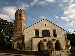
In June 2008, the village celebrated the 400th anniversary of the church bells with a week of events. [4]

Governance

The parish council has responsibility for local issues, including setting an annual precept (local rate) to cover the council's operating costs and producing annual accounts for public scrutiny. The parish council evaluates local planning applications and works with the local police, district council officers, and neighbourhood watch groups on matters of crime, security, and traffic. The parish council's role also includes initiating projects for the maintenance and repair of parish facilities, as well as consulting with the district council on the maintenance, repair, and improvement of highways, drainage, footpaths, public transport, and street cleaning. Conservation matters (including trees and listed buildings) and environmental issues are also the responsibility of the council.

For local government purposes, since 1 April 2023, the village comes under the unitary authority of Somerset Council. Prior to this, it was part of the non-metropolitan district of Somerset West and Taunton (formed on 1 April 2019) and, before this, the district of Taunton Deane (established under the Local Government Act 1972). Bishop's Hull was part of Taunton Rural District before that. [5]

It is also part of the Taunton Deane county constituency represented in the House of Commons of the Parliament of the United Kingdom. It elects one Member of Parliament (MP) by the first past the post system of election, and was part of the South West England constituency of the European Parliament prior to Britain leaving the European Union in January 2020, which elected seven MEPs using the d'Hondt method of party-list proportional representation.

Geography

Netherclay Community Woodland is a woodland with oak, ash, black poplar, dogwood and hazel. It is a local nature reserve. [6]

Landmarks

The manor house dates from 1586, with a mid-19th century addition and internal alterations, and further restoration in 1901. [7]

Rumwell Park

Rumwell Park house is a Grade II listed rococo mansion dating from 1857. It is located on Stonegallows, between Bishop's Hull and Galmington.

Rumwell Hall

Rumwell Hall is an historic manor house now a business centre. A new house on the site was built for Sir Edward Seymour in 1733. The current house was built for William Cadbury and completed about 1815. It was altered in the early 20th century for Charles Leslie Fox J.P. and restored in the late 20th century as an hotel. [8]

Hospice

Bishop's Hull is home to St Margaret's Somerset Hospice, which provides palliative care to cancer patients from across the area.

Frank Bond Centre

The Frank Bond Centre, established in 1983, is named after its benefactor, a local builder who had two hobbies: collecting theatre organs and keeping exotic birds. He opened his garden once a year to the general public and all money that was raised went to charity. On his death he left his house and garden (now the centre) and land to the community. [9] The land was used for development, some for housing and some for the building of St Margaret's Hospice.

Religious sites

The St Peter and St Paul's Church, on Bishop's Hull Hill, which is a Grade II* listed building dating from the 13th century, [10] and has an octagonal tower.

Until March 2005 [11] Taunton United Reformed Church had a church on Bishop's Hull Road, [12] the church was built in 1718 [13] and the building is a Grade II* listed building. [14] After the United Reformed Church in Bishop's Hull closed, services were moved to St Peter and St Paul's Church until 2013 when the United Reformed Church minister retired. [15]

Notable people

Related Research Articles

<span class="mw-page-title-main">Combe Florey</span> Human settlement in England

Combe Florey is a village and civil parish in Somerset, England, situated 6 miles (9.7 km) northwest of Taunton, on the West Somerset Railway. The village has a population of 261. The parish includes the hamlet of Eastcombe which is a linear settlement along the A358 Taunton-Wiliton Road.

<span class="mw-page-title-main">Milverton, Somerset</span> Human settlement in England

Milverton is a village and civil parish in Somerset, England, situated in the valley of the River Tone 5 miles (8.0 km) west of Taunton. The village has a population of 1,438. The parish includes the hamlet of Preston Bowyer.

<span class="mw-page-title-main">Cheddon Fitzpaine</span> Human settlement in England

Cheddon Fitzpaine is a village and civil parish in Somerset, England, situated on the Quantock Hills 2 miles (3.2 km) north of Taunton. The village is situated near the Bristol and Exeter Railway, the Bridgwater and Taunton Canal, and the River Tone and has a population of 1,929.

<span class="mw-page-title-main">Chipstable</span> Human settlement in England

Chipstable is a village and civil parish in Somerset, England, situated beside Heydon Hill 10 miles (16.1 km) west of Taunton. The parish has a population of 309.

<span class="mw-page-title-main">Churchstanton</span> Human settlement in England

Churchstanton is a village and civil parish in Somerset, England, situated within the Blackdown Hills Area of Outstanding Natural Beauty, on the River Otter 5 miles (8.0 km) south of Taunton.

<span class="mw-page-title-main">Cothelstone</span> Human settlement in England

Cothelstone is a village and civil parish in Somerset, England, situated in the Quantock Hills six miles north of Taunton. The parish, which includes the hamlet of Toulton, has a population of 111.

<span class="mw-page-title-main">Kingston St Mary</span> Human settlement in England

Kingston St Mary is a village and parish in Somerset, England, situated at the southern end of the Quantock Hills 4 miles (6.4 km) north of Taunton. The village has a population of 921.

<span class="mw-page-title-main">Langford Budville</span> Human settlement in England

Langford Budville is a village and civil parish in Somerset, England, situated near the River Tone 2 miles (3.2 km) north-west of Wellington, 4.5 miles (7.2 km) from Wiveliscombe and 6 miles (9.7 km) west of Taunton. The parish includes the hamlets of Bindon, Lower Chipley, Lower Wellisford, Ramsey and Runnington. The parish has a population of 535.

<span class="mw-page-title-main">Lydeard St Lawrence</span> Human settlement in England

Lydeard St Lawrence or St Lawrence Lydiard is a village and civil parish in Somerset, England, situated 7 miles (11.3 km) north west of Taunton. The village has a population of 506. The parish includes the hamlets of Westowe, Hoccombe and Pyleigh, with its 16th century manor house.

<span class="mw-page-title-main">Oake</span> Human settlement in England

Oake is a village and civil parish in Somerset, England, situated 5 miles (8.0 km) west of Taunton. The village has a population of 765.

<span class="mw-page-title-main">Pitminster</span> Human settlement in England

Pitminster is a village and civil parish in Somerset, England, situated 4 miles (6.4 km) south of Taunton. The parish has a population of 956. The parish also includes the villages of Angersleigh, Blagdon Hill and Staplehay. The village of Blagdon is now officially known as Blagdon Hill to distinguish it from Blagdon in North Somerset. Hillside hamlets in the parish comprise Feltham and Woodram, those on the lower plain in the north are Sellicks Green which is contiguous with Blagdon Hill, Duddlestone and Poundisford.

<span class="mw-page-title-main">Ruishton</span> Human settlement in England

Ruishton is a village and civil parish in Somerset, England, situated on the River Tone and A358 road 2 miles (3.2 km) east of Taunton. The village has a population of 1,473. The parish includes the hamlet of Henlade.

<span class="mw-page-title-main">Staple Fitzpaine</span> Human settlement in England

Staple Fitzpaine is a village and civil parish in Somerset, England, situated 5 miles (8.0 km) south of Taunton. The village has a population of 189 and is within the Blackdown Hills Area of Outstanding Natural Beauty. The parish includes the hamlet of Badger Street.

<span class="mw-page-title-main">Stawley</span> Human settlement in England

Stawley is a village and civil parish in Somerset, England, situated 10 miles (16.1 km) west of Taunton. The parish has a population of 279 and includes the village of Kittisford and the hamlets of Appley, Greenham and Tracebridge.

<span class="mw-page-title-main">Stoke St Gregory</span> Human settlement in England

Stoke St Gregory is a village and civil parish in Somerset, England, about 7 miles (11 km) east of Taunton. The village is on a low ridge of land between the River Tone to the north and West Sedgemoor to the south. The 2011 Census recorded the parish's population as 942.

<span class="mw-page-title-main">Tolland, Somerset</span> Human settlement in England

Tolland is a village and civil parish in Somerset, England, situated 9 miles (14.5 km) north west of Taunton, between the Brendon Hills and Quantock Hills. The parish has a population of 81.

<span class="mw-page-title-main">West Buckland</span> Human settlement in England

West Buckland is a village and civil parish in Somerset, England, situated 5 miles (8.0 km) south west of Taunton. The parish has a population of 1,189.

<span class="mw-page-title-main">West Hatch</span> Human settlement in England

West Hatch is a hamlet and civil parish in Somerset, England, situated 5 miles (8.0 km) south east of Taunton. It has a population of 306.

<span class="mw-page-title-main">Wiveliscombe</span> Town in Somerset, England

Wiveliscombe is a town and civil parish in Somerset, England, situated 9 miles (14 km) west of Taunton. The town has a population of 2,893. The Square, fronted by several listed structures, held the former market. The parish includes the nearby hamlet of Maundown.

Taunton Deane is a local government district with borough status in the English county of Somerset. In the United Kingdom, the term listed building refers to a building or other structure officially designated as being of special architectural, historical or cultural significance; Grade I structures are those considered to be "buildings of exceptional interest". Listing was begun by a provision in the Town and Country Planning Act 1947. Once listed, severe restrictions are imposed on the modifications allowed to a building's structure or its fittings. In England, the authority for listing under the Planning Act 1990 rests with Historic England, a non-departmental public body sponsored by the Department for Digital, Culture, Media and Sport; local authorities have a responsibility to regulate and enforce the planning regulations.

References

  1. 1 2 "Statistics for Wards, LSOAs and Parishes — SUMMARY Profiles" (Excel). Somerset Intelligence. Retrieved 4 January 2014.
  2. "Somerset Hundreds". GENUKI. Retrieved 21 October 2011.
  3. http://www.visionofbritain.org.uk/place/12969
  4. "Bells Week: Programme of Events" (PDF). Archived from the original (PDF) on 17 July 2011. Retrieved 6 May 2008.
  5. "Taunton RD". A vision of Britain Through Time. University of Portsmouth. Retrieved 5 January 2014.
  6. "Netherclay Community Woodland". Natural England. Retrieved 25 August 2015.
  7. Historic England. "Manor House (1060535)". National Heritage List for England . Retrieved 18 November 2008.
  8. "History timeline". Rumwell Hall.
  9. "The Frank Bond Community Centre". Bishops Hull Website. Archived from the original on 1 December 2008. Retrieved 18 December 2008.
  10. Historic England. "Church of St Peter and St Paul (1060537)". National Heritage List for England . Retrieved 18 November 2008.
  11. "Bishops Hull Village Website - Taunton Somerset". Bishops Hull Village Website. Bishops Hull Parish Council. Retrieved 27 December 2019.
  12. Historic England. "United Reformed Church and adjoining Hall to North (1308184)". National Heritage List for England . Retrieved 18 November 2008.
  13. "HISTORY - United Reformed Church". Taunton United Reformed Church. 3 March 2010. Retrieved 27 December 2019.
  14. Historic England. "UNITED REFORMED CHURCH AND ADJOINING HALL TO NORTH, Bishop's Hull (1308184)". National Heritage List for England . Retrieved 27 December 2019.
  15. "St Peter and St Paul - About Us". St Peter and St Paul. Retrieved 27 December 2019.