Bittou

Last updated
Bittou
Bittou panorama 2013.jpg
Burkina Faso location map.svg
Red pog.svg
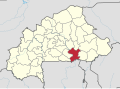
Bittou
Location in Burkina Faso
Coordinates: 11°15′27″N0°18′14″W / 11.25750°N 0.30389°W / 11.25750; -0.30389 Coordinates: 11°15′27″N0°18′14″W / 11.25750°N 0.30389°W / 11.25750; -0.30389
CountryFlag of Burkina Faso.svg  Burkina Faso
Region Centre-Est Region
Province Boulgou Province
Department Bittou Department
Population
 (2019 census) [1]
  Total31,210

Bittou is a town and seat of the Bittou Department of Boulgou Province in south-eastern Burkina Faso. The town is a stop on the caravan trading route. [2] Today the town is located along the N16 Road which links Burkina Faso with Northern Togo and Ghana (via Togo). In 1898 the French Colonial Army built a fort here to keep the British Colonial Army from capturing the area. [3] As of 2019, the town has a population of 31,210. [1]

Contents

Climate

Köppen-Geiger climate classification system classifies its climate as tropical wet and dry (Aw) that closely borders with hot semi-arid (BSh).

Climate data for Bittou
MonthJanFebMarAprMayJunJulAugSepOctNovDecYear
Average high °C (°F)35.1
(95.2)
36.6
(97.9)
38.4
(101.1)
37.9
(100.2)
35.6
(96.1)
32.9
(91.2)
30.8
(87.4)
30
(86)
30.9
(87.6)
34
(93)
36.1
(97.0)
34.7
(94.5)
34.4
(93.9)
Daily mean °C (°F)27.1
(80.8)
29
(84)
31.2
(88.2)
31.4
(88.5)
29.9
(85.8)
27.8
(82.0)
26.2
(79.2)
25.8
(78.4)
26.1
(79.0)
27.8
(82.0)
28.1
(82.6)
26.7
(80.1)
28.1
(82.6)
Average low °C (°F)19.1
(66.4)
21.4
(70.5)
24.1
(75.4)
25
(77)
24.3
(75.7)
22.7
(72.9)
21.7
(71.1)
21.6
(70.9)
21.4
(70.5)
21.7
(71.1)
20.2
(68.4)
18.8
(65.8)
21.8
(71.3)
Average precipitation mm (inches)0
(0)
1
(0.0)
11
(0.4)
36
(1.4)
87
(3.4)
116
(4.6)
180
(7.1)
239
(9.4)
155
(6.1)
47
(1.9)
4
(0.2)
3
(0.1)
879
(34.6)
Source: Climate-Data.org, altitude: 247m [4]

See also

Related Research Articles

<span class="mw-page-title-main">Koupéla</span> Place in Centre-Est, Burkina Faso

Koupéla is a city in Burkina Faso, lying east of Ouagadougou and west of Fada-Ngourma in an area settled by the Mossi people. It is known for its pottery and sculptures; these were made from natural clays found in the area. In 1900 Koupéla became the site of the first Catholic mission in Burkina Faso. Today it is the seat of an archdiocese, and contains a cathedral.

<span class="mw-page-title-main">Fada N'gourma</span> City in Est Region, Burkina Faso

Fada N'gourma, also written Fada-Ngourma or Noungu, is a city and an important market town in eastern Burkina Faso, lying 219 kilometres (136 mi) east of Ouagadougou, in the Gourmantché area. It is the capital of the East region and of Gourma province. It is known for its blanket and carpet manufacturing as well as its honey.

<span class="mw-page-title-main">Kaya, Burkina Faso</span> Regional capital in Centre-Nord, Burkina Faso

Kaya is the fifth largest city in Burkina Faso, lying northeast of Ouagadougou, to which it is connected by railway. It is a centre for weaving and tanning.

Diébougou is a town in Burkina Faso, situated 136 kilometres (85 mi) south-east of Bobo-Dioulasso on the main highway to Ghana. It is located 74 kilometres north of Gaoua and 133 km west of Leo, Burkina Faso and is the capital of Bougouriba Province.

<span class="mw-page-title-main">Komoé River</span> River in West Africa

The Komoé River or Comoé River is a river in West Africa. The river originates on the Sikasso Plateau of Burkina Faso, flow through the Cascades de Karfiguéla, forms a short section of the border between Burkina Faso and Ivory Coast until it enters Ivory Coast, where it is the major drainage for northeastern portion of that country before emptying into the Atlantic. The banks of the Komoé are shaded by riparian forests along most of it length providing an important habitat for wildlife and a source of agricultural water. Where reliable floodplains form in Ivory Coast, rice may be grown. A portion of the river in northern Ivory Coast is the source of the vegetative richness that earned that area a UNESCO World Heritage Site designation, Comoé National Park.

<span class="mw-page-title-main">Dori, Burkina Faso</span> Place in Sahel Region, Burkina Faso

Dori is a town in northeastern Burkina Faso, near the border of Niger. It is located at around 14.03°N 0.03°W. It is the capital of Sahel Region and has a population of 46,512 (2019). The main ethnic group is the Fula (Fulani) but Tuaregs, Songhai, and Hausa people are often present. It is a town known for its herders and popular livestock markets.

<span class="mw-page-title-main">Diapaga</span> Place in Burkina Faso

Diapaga is a city in and the capital of Tapoa Province in Burkina Faso. The main ethnic group in the city are the Gourmantché. The park headquarters for Burkina Faso are located in the town.

<span class="mw-page-title-main">Catholic Church in Burkina Faso</span>

The Catholic Church in Burkina Faso is part of the worldwide Catholic Church, under the spiritual leadership of the Pope in Rome. According to the CIA Factbook, in 2018 17 percent of the population are members of the Catholic Church.

Markoye is a town in northern Burkina Faso, in the province of Oudalan. It is the site of Burkina Faso’s coldest recorded temperature of 5.0 °C (41.0 °F).

Diaba Lompo was a 13th-century ruler, and the founder of the town of Fada N'Gourma, in Burkina Faso. His original name for Fada N'Gourma was Bingo. Fada N'Gourma is the easternmost major city in Burkina Faso. Nowadays it is nicknamed Fada.

Guiba or Djiba is a village in Burkina Faso. It is famous for being the traditional place where Mossi crown princes lived before they became Moro Naba (king).

<span class="mw-page-title-main">Party for Democracy and Rally</span>

The Party for Democracy and Rally was a political party in Burkina Faso led by Daouda Bayili.

Mané is a town in Burkina Faso. It is the capital of Mane Department in Sanmatenga Province. Mané one of the Mossi principalities and was founded in the 16th century.

Tamassari is a town in western Burkina Faso near Sindou and near the border with Mali.

Yankasso is a village in the Safané Department of Mouhoun province of Burkina Faso. It was the site of a serious defeat of the French colonial forces in December 1915.

Rawa (Ra-wa) was the developer of the government of Mossi. He was titled one of the masters of war for his accomplishments as a conqueror. A son of Ouedraogo, he is one of the three siblings of the founders of the Mossi and the first citizens of Mossi. While his younger brother, Zoungrana, overlooked the city of Tenkodogo, and his other brother, Diaba Lompo, headed south and founded Gurmanche, Rawa traveled north to establish the city of Zandana.

Ouédraogo was the son of Yennenga and progenitor of the Mossi Kingdoms. He founded the kingdom of Tenkodogo. His three sons were Rawa, Diaba Lompo, and Zoungourana.

Zoungrana, was a Mossi ruler, either the first or second ruler of Tenkodogo. He was the third son of Ouedraogo.

Joséphine Ki-Zerbo (1936-2019) was an educator and activist from Burkina Faso. She was the wife of Joseph Ki-Zerbo.

References

  1. 1 2 Citypopulation.de Population of cities & localities in Burkina Faso
  2. Historical Dictionary of Burkina Faso, by Lawrence Rupley, Lamissa Bangali, Boureima Diamitani, 2013, Third edition, Scarecrow Press, Inc. ISBN   978-0-8108-6770-3
  3. Historical Dictionary of Burkina Faso, by Lawrence Rupley, Lamissa Bangali, Boureima Diamitani, 2013, Third edition, Scarecrow Press, Inc. ISBN   978-0-8108-6770-3
  4. "Climate: Bittou - Climate graph, Temperature graph, Climate table". Climate-Data.org. Retrieved 19 October 2013.