Gitnadoiks River Provincial Park is a 58,000 hectare provincial park in British Columbia, Canada. It is centred on the Gitnadoix River, a tributary of the Skeena River in Northwestern British Columbia, 50 km west of Terrace.
Within the traditional territory of the Tsimshian people, the park is in a remote, wilderness setting in the Kitimat Ranges of the Coast Mountains and is inaccessible by road.
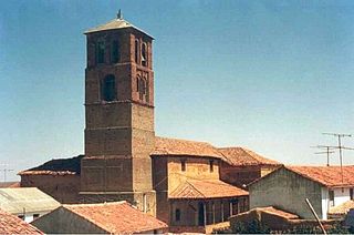
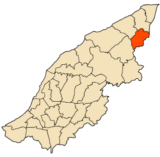
Mayorga de Campos is a town and municipality in Valladolid province, Spain, part of the autonomous community of Castile and León, Spain. Its name comes from the Leonese language, and there are several references to this village in the Middle Ages, in which Mayorga was a place in the Kingdom of León.
Bacolet is a town and suburb in the city of Scarborough on the island of Tobago, Republic of Trinidad and Tobago. The town itself lies beneath Fort King George at the Bacolet Bay, just outside the city center to the south-east of the islands capital. It is one of the most developed parts of Tobago where the high society of the island lives. There are also many villas and hotels for tourists.
Cerca-la-Source is an arrondissement (district) in the Centre department of Haiti. As of 2015, the population was 119,756 inhabitants. Postal codes in the Cerca-la-Source Arrondissement start with the number 54.
Chardonnières is an arrondissement in the Sud department of Haiti. As of 2015, the population was 78,410 inhabitants. Postal codes in the Chardonnières Arrondissement start with the number 85.

Borzęcin is a village in the administrative district of Gmina Gorzkowice, within Piotrków County, Łódź Voivodeship, in central Poland. It lies approximately 6 kilometres (4 mi) south of Gorzkowice, 27 km (17 mi) south of Piotrków Trybunalski, and 70 km (43 mi) south of the regional capital Łódź.

Miękinia is a village in the administrative district of Gmina Krzeszowice, within Kraków County, Lesser Poland Voivodeship, in southern Poland. It lies approximately 5 kilometres (3 mi) north-west of Krzeszowice and 27 km (17 mi) north-west of the regional capital Kraków.
Malkowice is a village in the administrative district of Gmina Koszyce, within Proszowice County, Lesser Poland Voivodeship, in southern Poland. It lies approximately 2 kilometres (1 mi) east of Koszyce, 22 km (14 mi) east of Proszowice, and 49 km (30 mi) east of the regional capital Kraków.
Boży Dar is a village in the administrative district of Gmina Lipsko, within Lipsko County, Masovian Voivodeship, in east-central Poland. It lies approximately 5 kilometres (3 mi) west of Lipsko and 124 km (77 mi) south of Warsaw.
Targówka is a village in the administrative district of Gmina Mińsk Mazowiecki, within Mińsk County, Masovian Voivodeship, in east-central Poland. It lies approximately 3 kilometres (2 mi) south-east of Mińsk Mazowiecki and 42 km (26 mi) east of Warsaw.
Kadłubowo is a village in the administrative district of Gmina Dzierzążnia, within Płońsk County, Masovian Voivodeship, in east-central Poland. It lies approximately 6 kilometres (4 mi) south-west of Dzierzążnia, 16 km (10 mi) west of Płońsk, and 71 km (44 mi) north-west of Warsaw.
Sangrave is a town and commune in the Brakna Region of southern Mauritania.
Miączynek is a settlement in the administrative district of Gmina Skoki, within Wągrowiec County, Greater Poland Voivodeship, in west-central Poland. It lies approximately 8 kilometres (5 mi) south of Skoki, 23 km (14 mi) south of Wągrowiec, and 28 km (17 mi) north-east of the regional capital Poznań.
Nowa Wieś Podgórna is a village in the administrative district of Gmina Miłosław, within Września County, Greater Poland Voivodeship, in west-central Poland. It lies approximately 10 kilometres (6 mi) south-east of Miłosław, 19 km (12 mi) south of Września, and 54 km (34 mi) south-east of the regional capital Poznań.
Hassi Attilla is a village and rural commune in Mauritania.
Nékmaria is a town and commune in Mostaganem Province, Algeria. It is located in Achacha District. According to the 1998 census it has a population of 9,104.
Ecuandureo is a municipality in the Mexican state of Michoacán. It is located in the northwestern part of the state and its head is the town of Ecuandureo.
Paraíso is a corregimiento in Pocrí District, Los Santos Province, Panama with a population of 597 as of 2010. Its population as of 1990 was 574; its population as of 2000 was 593.
Paritilla is a corregimiento in Pocrí District, Los Santos Province, Panama with a population of 783 as of 2010. Its population as of 1990 was 977; its population as of 2000 was 840.
Boró is a corregimiento in La Mesa District, Veraguas Province, Panama with a population of 1,757 as of 2010. Its population as of 1990 was 2,158; its population as of 2000 was 1,959.


