
Andalusia is a village in Rock Island County, Illinois, United States. The population was 1,178 at the 2010 census, an increase from 1,050 in 2000.

Bawku is a town and is the capital of the Bawku Municipal District, district in the Upper East region of north Ghana. Bawku has a 2012 settlement population of 69,527 people.

Ouargaye is a city located in the province of Koulpélogo in Burkina Faso. It is the capital of Koulpélogo Province. Ouargaye is twinned with Fougères in Brittany, France
Ravernet is a village and townland in County Down, Northern Ireland. It is on the Ravernet River, about 3km south of Lisburn and about 3km northeast of Hillsborough. Nearby is Sprucefield and the M1 motorway. In the 2001 Census it had a population of 559.
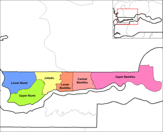
Lower Baddibu is one of the six districts of the North Bank Division of the Gambia.
HMS Bullen was a Buckley class Captain class frigate during World War II. Named after Captain Charles Bullen of HMS Britannia at the battle of Trafalgar.

Villaobispo de Otero is a municipality located in the province of León, Castile and León, Spain. According to the 2004 census (INE), the municipality has a population of 665 inhabitants.
Isuerre is a municipality located in the province of Zaragoza, in Aragon, Spain. According to the 2004 census (INE), the municipality has a population of 53 inhabitants.
Léré (Burkina) is a village in the Bané Department of Boulgou Province in south-eastern Burkina Faso. As of 2005, the village has a population of 684.
Youga is a village in the Zabré Department of Boulgou Province in south-eastern Burkina Faso, about 2 km north from border with Ghana. As of 2005, the village had a population of 1018, but due to discovery of gold in the vicinity and subsequent establishment of Youga Gold Mine, population is growing.
Dassari is a village in the Manni Department of Gnagna Province in eastern Burkina Faso. The village has a population of 981.
The Henry Kater Peninsula is a peninsula on northern Baffin Island, in Nunavut, Canada. It protrudes in an eastern direction into Davis Strait. It's bounded to the north by Arctic Harbour. Further north lies Clyde Inlet. Home Bay borders the peninsula to the south.
Tysoe is a civil parish in the Stratford-on-Avon district, in the county of Warwickshire, England, 9 miles (14 km) north-west of Banbury. The three main settlements in the parish, Upper, Middle and Lower Tysoe are on a hill, hence the respective village names. Upper and Middle Tysoe have now merged, whereas Lower Tysoe is still separate, a little further north. The estimated population of the parish is 1,050, based on the 2001 UK Census.

Nghĩa Tá is a commune (xã) and village in Chợ Đồn District, Bắc Kạn Province, in Vietnam.
Branžež is a village and municipality in Mladá Boleslav District in the Central Bohemian Region of the Czech Republic.

Bou Hanifia is a town and commune located at 35° 18′ 58″ North 0° 02′ 54″ East in Mascara Province, Algeria. According to the 1998 census it has a population of 16,953. and a density of 77 hab./km2
Leiva is a village in the province and autonomous community of La Rioja, Spain. The municipality covers an area of 12.71 square kilometres (4.91 sq mi) and as of 2011 had a population of 304 people.
German submarine U-614 was a Type VIIC U-boat built for Nazi Germany's Kriegsmarine for service during World War II. She was laid down on 6 May 1941 by Blohm & Voss, Hamburg as yard number 590, launched on 29 January 1942 and commissioned on 19 March 1942 under Oberleutnant zur See Wolfgang Sträter.
German submarine U-767 was a Type VIIC U-boat built for Nazi Germany's Kriegsmarine for service during World War II. She was laid down on 5 April 1941 by Kriegsmarinewerft Wilhelmshaven as yard number 150, launched on 10 July 1943 and commissioned on 11 September 1943 under Oberleutnant zur See Walter Dankleff.
German submarine U-668 was a Type VIIC U-boat of Nazi Germany's Kriegsmarine during World War II. The submarine was laid down on 11 October 1941 at the Howaldtswerke yard at Hamburg, launched on 5 October 1942, and commissioned on 16 November 1942 under the command of Oberleutnant zur See Wolfgang von Eickstedt.


