Houghton Bank is a village in the borough of Darlington and the ceremonial county of County Durham, England. It is situated a few miles west of Newton Aycliffe, on the A68 between Darlington and Bishop Auckland.

The Mercedes-Benz M275 engine is a twin-turbocharged and intercooled, all-aluminum, 60° V12 automobile piston engine family used in the 2000s to the 2010s. It is loosely based on the M137 naturally aspirated V12 sold between 1998 and 2002, and retains its SOHC, 3 valves per cylinder, twin-spark ignition layout, but differs with the addition of structural reinforcements to the engine block for improved rigidity which in turn yields greater reliability. Bore and stroke is 82 mm × 87 mm giving a displacement of 5,513 cc (5.5 L). Power output is 380 kW at 5000 rpm with 830 N⋅m (612 lb⋅ft) of torque at 1800–3500 rpm.

The Suzuki Bandit is a series of standard motorcycles produced by Suzuki since 1989. The Bandit series includes the following models:
Murchante is a town and municipality located in the province and autonomous community of Navarre, northern Spain.

Pueyo is a town located in the province and autonomous community of Navarre, northern Spain.
Tirapu is a town and municipality located in the province and autonomous community of Navarre, northern Spain.

Grenadines is an administrative parish of Saint Vincent and the Grenadines. Its capital is Port Elizabeth.

The Capitol State Forest is a 91,650-acre (370.9 km2) state forest in Thurston and Grays Harbor counties of the U.S. state of Washington. It includes part of the unusual Mima Mounds geologic feature.

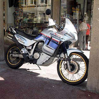
The Honda Transalp is the XL400V, XL600V, XL650V, and XL700V series of dual-sport motorcycles manufactured in Japan by Honda since 1987. The Transalp bikes series feature a liquid-cooled, four-stroke 52° V-twin engine.
Esparragosa de la Serena is a municipality in the province of Badajoz, Extremadura, Spain. It has a population of 1,108 and an area of 21.66 km².
Jandaia do Sul is a town located in the state of Paraná in Brazil.
Valderrábano is a municipality located in the province of Palencia, Castile and León, Spain. According to the 2004 census (INE), the municipality has a population of 65 inhabitants.
Villafranca de Ebro is a municipality located in the province of Zaragoza, Aragon, Spain. According to the 2004 census (INE), the municipality has a population of 684 inhabitants.
Boro is a town in the Pâ Department of Balé Province in south-western Burkina Faso. The town has a population of 1300.
Makoula is a town in the Siglé Department of Boulkiemdé Province in central western Burkina Faso. It has a population of 2,191.
El Ghabra is a town and commune in Mauritania.

Balizia is a town and sub-prefecture in the Macenta Prefecture in the Nzérékoré Region of south-eastern Guinea.
Chigmecatitlan is a town and municipality in Puebla in south-eastern Mexico. It has a population of 1,137 people and covers an area of 28.06 square kilometres (10.83 sq mi).

Assin Fosu is a small town and is the capital of Assin North Municipal, a Municipal in the Central Region of Ghana. Assin Fosu is the 65th most populous settlement in Ghana, with a population of 20,541. The town is known for the Obiri Yeboah Secondary School School. The school is a second cycle institution.


