
Sud-Est is one of the ten departments of Haiti. It has an area of 2,034.10 km² and a population of 632,601 (2015). Its capital is Jacmel.

Spiny is a village in the administrative district of Gmina Pakosławice, within Nysa County, Opole Voivodeship, in south-western Poland. It lies approximately 9 kilometres (6 mi) west of Pakosławice, 12 km (7 mi) north-west of Nysa, and 52 km (32 mi) west of the regional capital Opole.
Gwillim Lake Provincial Park is a provincial park in British Columbia, Canada.
Jamalganj is an Upazila of Sunamganj District in the Division of Sylhet, Bangladesh.

Partido de la Sierra en Tobalina is a municipality located in the province of Burgos, Castile and León, Spain. According to the 2004 census (INE), the municipality has a population of 68 inhabitants. Its seat is in Valderrama.

Oued Tlélat is a district in Oran Province, Algeria, one of the two landlocked districts of the province. It was named after its capital, Oued Tlélat.
Kawkareik Township is a township of Kawkareik District in the Karen State of Myanmar. The principal town is Kawkareik. Kawkareik township is the second most populated township in Karen State and there are many small villages inside.
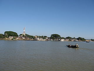
Bhamo Township is a township of Bhamo District in the Kachin State of Burma. The principal town is Bhamo.

Perigban is a department or commune of Poni Province in southern Burkina Faso. Its capital lies at the town of Perigban.

Tô is a department or commune of Sissili Province in southern Burkina Faso. Its capital lies at the town of Tô.

Bassi is a department or commune of Zondoma Province in western Burkina Faso. Its capital lies at the town of Bassi.
Olszowa is a village in the administrative district of Gmina Jastrzębia, within Radom County, Masovian Voivodeship, in east-central Poland. It lies approximately 6 kilometres (4 mi) north of Jastrzębia, 18 km (11 mi) north of Radom, and 76 km (47 mi) south of Warsaw.
Słupice is a village in the administrative district of Gmina Pakosławice, within Nysa County, Opole Voivodeship, in south-western Poland. It lies approximately 9 kilometres (6 mi) west of Pakosławice, 12 km (7 mi) north-west of Nysa, and 52 km (32 mi) west of the regional capital Opole.
Guacá is a corregimiento in David District, Chiriquí Province, Panama. It has a land area of 69.2 square kilometres (26.7 sq mi) and had a population of 1,891 as of 2010, giving it a population density of 27.3 inhabitants per square kilometre (71/sq mi). Its population as of 1990 was 1,483; its population as of 2000 was 1,726.
Dos Ríos is a corregimiento in Dolega District, Chiriquí Province, Panama. It has a land area of 18.1 square kilometres (7.0 sq mi) and had a population of 1,634 as of 2010, giving it a population density of 90.2 inhabitants per square kilometre (234/sq mi). Its population as of 1990 was 1,172; its population as of 2000 was 1,352.
Tinajas is a corregimiento in Dolega District, Chiriquí Province, Panama. It has a land area of 29.4 square kilometres (11.4 sq mi) and had a population of 1,530 as of 2010, giving it a population density of 52 inhabitants per square kilometre (130/sq mi). Its population as of 1990 was 1,084; its population as of 2000 was 1,237.
El Nancito is a corregimiento in Remedios District, Chiriquí Province, Panama. It has a land area of 35.4 square kilometres (13.7 sq mi) and had a population of 607 as of 2010, giving it a population density of 17.1 inhabitants per square kilometre (44/sq mi). Its population as of 1990 was 786; its population as of 2000 was 519.
Santa Cruz is a corregimiento in San Félix District, Chiriquí Province, Panama. It has a land area of 55.7 square kilometres (21.5 sq mi) and had a population of 416 as of 2010, giving it a population density of 7.5 inhabitants per square kilometre (19/sq mi). It was created by Law 10 of March 7, 1997; this measure was complemented by Law 5 of January 19, 1998 and Law 69 of October 28, 1998. Its population as of 2000 was 367.
Veladero is a corregimiento in Tolé District, Chiriquí Province, Panama. It has a land area of 51.1 square kilometres (19.7 sq mi) and had a population of 1,727 as of 2010, giving it a population density of 33.8 inhabitants per square kilometre (88/sq mi). It was created by Law 10 of March 7, 1997; this measure was complemented by Law 5 of January 19, 1998 and Law 69 of October 28, 1998. Its population as of 2000 was 1,575.
El Prado is a corregimiento in Las Palmas District, Veraguas Province, Panama with a population of 1,074 as of 2010. Its population as of 1990 was 4,971; its population as of 2000 was 1,103.


