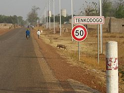
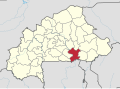
Tenkodogo

Last updated
Tenkodogo
Tenkodogo-Entree.jpg
Burkina Faso location map.svg
Red pog.svg
Tenkodogo
Location within Burkina Faso
Coordinates: 11°47′N0°22′W / 11.783°N 0.367°W / 11.783; -0.367
CountryFlag of Burkina Faso.svg  Burkina Faso
Region Centre-Est Region
Province Boulgou Province
Department Tenkodogo Department
Elevation
234 m (768 ft)
Population
 (2019 census) [1]
  Total61,936
Time zone UTC+0 (GMT)

Tenkodogo is the capital city of Boulgou Province and the Centre-Est Region of Burkina Faso with a population of 61,936 (2019). Tenkodogo is also the capital of the Tenkodogo Mossi Kingdom and considered to be root of all other Mossi Kingdoms, having been found circa 1100. The literal translation of Tenkodogo is ancient-land. [1] [2]

Contents

Economy

The villages surrounding Tenkodogo are primarily based around animal husbandry.

The main market takes place every 3 days.

The Restaurant Patisserie Salon du Thé is known for its tea, yoghurt and pastries.

The Le Rotisseur restaurant is known for its grilled chicken.

Notable hotels include Hotel Djamou, Hotel Djamou Annexe, Hotel Laafi, and Auberge Riale. [3]

Politics

On 29 January 2016, the king of Tenkodogo, Naba Saga, died while in Thailand for hospital care. [4] He was the 28th king of Tenkodogo according to tradition and was inducted on 5 October 2001. He had taken the position after the death of his father, Naba Tigre, in September 2001. He was succeeded by Naba Guiguem-Pollé as king. [5]

Transport

The town is connected to Koupéla and Bittou, along the N15 highway.

Companies such as STAF, TSF, TSR, TCV and many more provide multiple daily services to Ouagadougou.

Tenkodogo is approximately 185 km from Ouagadougou and it takes about 3h30min by vehicle.

Development

In the period leading up to the 2019 edition of 11 Dècembre festivity, Tenkodogo had a massive improvement to its road network. Multiple roads and roundabouts were asphalted making movements within the city much faster. Tenkodogo also had the removal of its dirt runway to make way for the 11 Dècembre neighbourhood (colloquially known as "Cité 11 Decémbre") which is full of modern villas and houses.


Royal Family

The headquarters of the royal family is located within the Palais Royal de Tenkodogo (colloquially known as Na-Yiri in Mooré language) located at a close proximity to the market (Marchè de Tenkodogo or Tenkodogo Raaga in Mooré language ).

The current head of the family is His Majesty King Naba Guiguem-Pollé, King of the Kingdom of Tenkodogo and Rima of Zoungrantenga.

The majority of descendants of the royal family carry the surname Sorgho and they are colloquially known as the naabisi (royals) of the city.

The royal family are still a key figure in the city and they still mediate over land or family disputes in the city.

Climate

Köppen-Geiger climate classification system classifies its climate as hot semi-arid (BSh) that closely borders with tropical wet and dry (Aw).

Climate data for Tenkodogo
MonthJanFebMarAprMayJunJulAugSepOctNovDecYear
Average high °C (°F)34.2
(93.6)
35.9
(96.6)
38.9
(102.0)
39.2
(102.6)
36.5
(97.7)
33.9
(93.0)
31.5
(88.7)
30.4
(86.7)
31.6
(88.9)
34.7
(94.5)
36
(97)
34.4
(93.9)
34.8
(94.6)
Daily mean °C (°F)26.5
(79.7)
28.6
(83.5)
31.5
(88.7)
32.4
(90.3)
30.5
(86.9)
28.4
(83.1)
26.7
(80.1)
25.9
(78.6)
26.5
(79.7)
28.4
(83.1)
28.2
(82.8)
26.6
(79.9)
28.4
(83.0)
Average low °C (°F)19.8
(67.6)
21.3
(70.3)
24.1
(75.4)
25.6
(78.1)
24.6
(76.3)
23
(73)
21.9
(71.4)
21.4
(70.5)
21.4
(70.5)
22.1
(71.8)
20.4
(68.7)
18.8
(65.8)
22.0
(71.6)
Average precipitation mm (inches)1
(0.0)
3
(0.1)
11
(0.4)
26
(1.0)
79
(3.1)
110
(4.3)
177
(7.0)
243
(9.6)
150
(5.9)
35
(1.4)
1
(0.0)
2
(0.1)
838
(32.9)
Source: Climate-Data.org, elevation: 309 m [6]

Demographics

YearPopulation
198523,331 [7]
199631,466 [7]
200644,491 [7]

See also

Related Research Articles

<span class="mw-page-title-main">Ouagadougou</span> Capital of Burkina Faso

Ouagadougou or Wagadugu is the capital of Burkina Faso, and the administrative, communications, cultural and economic centre of the nation. It is also the country's largest city, with a population of 2,415,266 in 2019. The city's name is often shortened to Ouaga. The inhabitants are called ouagalais. The spelling of the name Ouagadougou is derived from the French orthography common in former French African colonies.

<span class="mw-page-title-main">Provinces of Burkina Faso</span> Subdivisions of Burkina Faso

The regions of Burkina Faso are divided into 45 administrative provinces. These 45 provinces are currently sub-divided into 351 departments or communes.

<span class="mw-page-title-main">Mossi people</span> Ethnic group of Burkina Faso

The Mossi are a Gur ethnic group native to modern Burkina Faso, primarily the Volta River basin. The Mossi are the largest ethnic group in Burkina Faso, constituting 52% of the population, or about 11.1 million people. The other 48% of Burkina Faso's population is composed of more than 60 ethnic groups, mainly the Gurunsi, Senufo, Lobi, Bobo, Bissa and Fulani. The Mossi speak the Mòoré language.

<span class="mw-page-title-main">Koudougou</span> City in the Centre-Ouest Region, Burkina Faso

Koudougou is a city in Burkina Faso's Boulkiemdé Province. It is located 75 kilometres (47 mi) west of Ouagadougou, the capital of Burkina Faso. With a population of 160,239 (2019), it is the third most populous city in Burkina Faso after Ouagadougou and Bobo Dioulasso, and is mainly inhabited by the Gurunsi and Mossi ethnic groups. Koudougou is situated on the only railway line in Burkina Faso and has some small industries, a market, a university and provincial government offices.

<span class="mw-page-title-main">Kaya, Burkina Faso</span> Regional capital in Centre-Nord, Burkina Faso

Kaya is the fifth largest city in Burkina Faso, lying northeast of Ouagadougou, to which it is connected by railway. It is a centre for weaving and tanning.

<span class="mw-page-title-main">Ouahigouya</span> Town in Nord Region, Burkina Faso

Ouahigouya is a town in northern Burkina Faso, situated 182 kilometres northwest of Ouagadougou. It is the capital of the Yatenga Province and one of its subdivisions the Ouahigouya Department. It is also the biggest town in the Nord Region and the fourth largest city in the country with a population of 124,587 (2019)

<span class="mw-page-title-main">Banfora</span> City in the Cascades Region, Burkina Faso

Banfora is a city in south western Burkina Faso, with a population of 117,452 making it the sixth most populous city in Burkina Faso. It is the capital of the Comoe province. The city lies 85 kilometres (53 mi) south-west of Bobo-Dioulasso, on the Abidjan – Ouagadougou Railway. The Cascades de Karfiguéla are a series of waterfalls close to Banfora.

<span class="mw-page-title-main">Yatenga Province</span> Province in Nord Region, Burkina Faso

Yatenga is one of the provinces of Burkina Faso, located in the Nord Region of the country. In modern Yatenga, the most prominent city is Ouahigouya. This city served as the capital of the kingdom of Yatenga, a powerful kingdom out of the many Mossi kingdoms, but its influence decreased in the century following French colonisation. The city is famed today for being home to the Naba's compound and the tomb of Naba Kango.

<span class="mw-page-title-main">Kongoussi</span> Place in Centre-Nord Region, Burkina Faso

Kongoussi is a city located in Bam Province in central Burkina Faso, one of the world's poorest countries. It has a population of 53,627 (2019) and is the provincial capital. Mooré, the language of the Mossi people, is spoken along with French, common among those who have attended school or spent time further afield.

<span class="mw-page-title-main">Mossi Kingdoms</span> Historical kingdoms in modern-day Burkina Faso

The Mossi Kingdoms, sometimes referred to as the Mossi Empire, were a group of powerful kingdoms in modern-day Burkina Faso which dominated the region of the upper Volta river for hundreds of years. The largest Mossi kingdoms was that of Ouagadougou and the king of Ouagadougou known as the Mogho Naaba, or King of All the World, serves as the Emperor of all the Mossi. The first kingdom was founded when Dagomba warriors from the region that is present-day Ghana and Mandé warriors moved into the area and intermarried with local people. Centralization of the political and military powers of the kingdoms begin in the 13th century and led to conflicts between the Mossi kingdoms and many of the other powerful states in the region. In 1896, the French took over the kingdoms and created the French Upper Volta which largely used the Mossi administrative structure for many decades in governing the colony.

Articles related to Burkina Faso include:

Naba may refer to:

Musée de Manega or Manega Museum is a museum located 55 km (34 mi) northwest of the city Ouagadougou, in the village of Manega, Burkina Faso. It was established by Frédéric Pacéré Titinga.

<span class="mw-page-title-main">Zimtenga Department</span> Department in Centre-Nord Region, Burkina Faso

Zimtenga, also spelt Zimtanga, is a department or commune of Bam Province in Centre-Nord Region of Burkina Faso. Its capital lies at the town of Zimtenga. According to the 1996 census the department has a total population of 21,879.

<span class="mw-page-title-main">Tenkodogo Department</span> Department in Boulgou Province, Burkina Faso

Tenkodogo is a department or commune of Boulgou Province in eastern Burkina Faso. Its capital is the town of Tenkodogo. According to the 2019 census the department has a total population of 157,947.

<span class="mw-page-title-main">Wobgho</span>

Wobogo was the Mogho Naba (ruler) of Ouagadougou from 1890 to 1897, at the time of the French colonial conquest of Upper Volta. Wobogu was originally called Boukary Koutou, but dropped those names on his accession and assumed the name "Wobogu", meaning elephant.

The Yarse, also spelt Yarsé, Yarsin or Yarcin, are a people of Burkina Faso, living among the Mossi. The population in the mid-1990s was estimated at 190,000, of whom 90% were Muslims.

Naba Baongo II is the current Mogho Naba, the constituent king of the Mossi people of Burkina Faso. According to oral tradition, he is the 37th king of the Mossi. As king, he is seen as a symbol of tradition and still retains influence in political matters within the country, and elected MPs, ministers, and ambassadors are known to seek his approval.

Naba Kougri was, according to the traditional order, the 36th Mogho Naba of Ouagadougou, the king of the Mossi people of Burkina Faso. He was the son of the previous Mogho Naba, Sagha II. He reigned from 1957 to his death on 8 December 1982.

References

  1. 1 2 Citypopulation.de Population of cities & localities in Burkina Faso
  2. Manson, Katrina, Knight, James (2006). Burkina Faso. The Globe Pequot Press Inc. p.  183. ISBN   1-84162-154-4.{{cite book}}: |work= ignored (help)CS1 maint: multiple names: authors list (link)
  3. Manson, Katrina, Knight, James (2006). Burkina Faso. The Globe Pequot Press Inc. p.  184. ISBN   1-84162-154-4.{{cite book}}: |work= ignored (help)CS1 maint: multiple names: authors list (link)
  4. "Décès du roi de Tenkodogo : Qui était Naba Saga ? - leFaso.net, l'actualité au Burkina Faso". lefaso.net (in French). Retrieved 2017-03-10.
  5. "Palais royal de Tenkodogo : Les autorités régionales sollicitent l'accompagnement de Naba Guiguem-Pollé". www.sidwaya.bf. Retrieved 2017-03-10.
  6. "Climate: Tenkodogo - Climate graph, Temperature graph, Climate table". Climate-Data.org. Retrieved 19 October 2013.
  7. 1 2 3 "La région du Centre-Est en chiffres" (PDF). 2011. Retrieved 9 March 2017.

Commons-logo.svg Media related to Tenkodogo at Wikimedia Commons

11°47′N0°22′W / 11.783°N 0.367°W / 11.783; -0.367