
The Western Kentucky Botanical Garden (WKBG) is a botanical garden in Owensboro, Kentucky. The Garden contains several themed gardens including a large collection of daylilies with an American Hemerocallis Society-recognized display garden. Other gardens include a large herb garden, a rose garden, an English cottage garden, a Kentucky symbol quilt garden, a Japanese memorial garden, an ericaceous garden, the Moonlite Children’s garden, the University of Kentucky Extension display garden, and a Western Kentucky University experimental garden.. The Garden also includes several ponds and many works of public art including insect and wind sculptures.
Lónguida – Longida is a town and municipality located in the province and autonomous community of Navarre, northern Spain.

The Morropón Province is one of eight provinces of the Piura Region in Peru. The province was created in 1936. Its administrative center is in the town of Chulucanas.
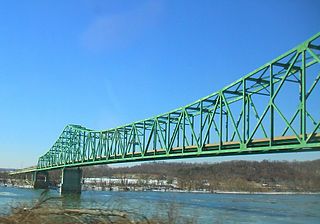
The William S. Ritchie Jr. Bridge, more commonly known as the Ravenswood Bridge, is a two-lane cantilever bridge in the United States, connecting Ravenswood, West Virginia and rural Meigs County, Ohio, across the Ohio River. It has a total length of 2,710 ft (830 m) with a main span of 900 ft (270 m). The bridge was completed in 1981.

Five Themes of Geography is an educational tool for teaching geography. Adopted in 1984 by the Association of American Geographers, those five themes were published in the NCGE/AAG publication Guidelines for Geographic Education, Elementary, and Secondary Schools. Most American geography and social studies classrooms have adopted the five themes in teaching practices.

Mansfield Road is a road in central Oxford, England. It runs north-south with two of Oxford University's colleges on it, Mansfield College and Harris Manchester College, and Queen Elizabeth House which houses the Oxford Department of International Development.

Guadalupe is a town and municipality in the Huila Department, Colombia.

The Bodleian Social Science Library, Oxford (SSL) is the main teaching social sciences lending library at the University of Oxford, England. The library supports taught programmes for both undergraduates and postgraduates, and houses a dedicated research collection part of which contains legal deposit material out-housed from the Bodleian Library. The Social Science Library uses the Library of Congress classification scheme.

Oxford University Department for Continuing Education (OUDCE) is a department within the University of Oxford that provides continuing education mainly for part-time and mature students. It is located at Rewley House, Wellington Square, Oxford, England.
Cutervo District is one of fifteen districts of the province Cutervo in Peru.
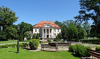
Tłokinia Kościelna is a village in the administrative district of Gmina Opatówek, within Kalisz County, Greater Poland Voivodeship, in west-central Poland.

The Phonetics Laboratory is the phonetics laboratory at the University of Oxford, England. It is located at 41 Wellington Square, Oxford.
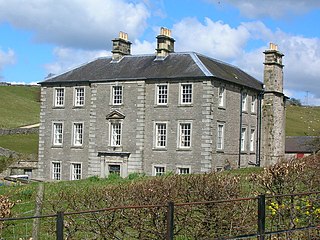
Castern Hall, also known as Casterne Hall, is a privately owned 18th-century country house in the Manifold Valley, near Ilam, Staffordshire, England. It is the home of the Hurt family, who have owned the land since the mid-16th century.
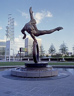
The Flair is a bronze statue in Atlanta, Georgia by artist Richard MacDonald finished in 1996 before the 1996 Summer Olympics. It stands just east of the Georgia Dome in the Georgia World Congress Center complex.
Jardines Del Humaya is a cemetery outside the city of Culiacán, in the Mexican state of Sinaloa, established in 1969. Sinaloa is known for its drug related activities and violence. The cemetery has gained notoriety for its mausoleums built for deceased cartel members that are unique and lavish in their style. They resemble real life houses and the associated opulence that these cartel members were used to prior to their deaths.
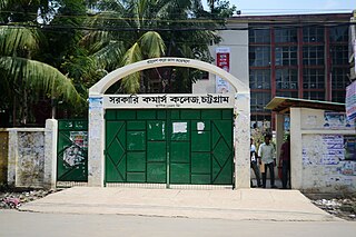
Government College of Commerce, Chittagong is a government college in Agrabad, Chittagong, Bangladesh. It was established in 1947.
Babcock Lake is a lake in Yosemite National Park of California.

Howe Dell is a 4 hectare Local Nature Reserve in Hatfield in Hertfordshire. The declaring authority is Welwyn Hatfield Borough Council. The site is woodland which runs along both sides of a stream with steep sides. The main trees are hornbeam, oak and beech. There is access from Honeysuckle Gardens.
Dixon High School is a high school in Dixon, California. It is the only high school in the town of about 18,000. It is part of the Dixon Unified School District.

The Greek Ambassador to Russia is the ambassador of the Greek government to the government of Russia.


