
Bane is a fictional supervillain appearing in American comic books published by DC Comics. Created by Dennis O'Neil, Chuck Dixon, Doug Moench and Graham Nolan, he first appeared in Batman: Vengeance of Bane #1. The character is an adversary of the superhero Batman and belongs to the collective of enemies that make up his rogues gallery. With a mix of brute strength and exceptional intelligence, Bane is often credited as being the only villain to have "broken the bat".

Lambert's Point Deperming Station is a United States Navy deperming facility located in the Elizabeth River just off Lambert's Point, Norfolk, Virginia, United States. It was built in the mid-1940s and services the U.S. Atlantic Fleet.

Boecillo is a municipality located in the province of Valladolid, Castile and León, Spain. According to the 2009 census (INE), the municipality has a population of 3324 inhabitants.

The Saxon Mill is a former mill at Guy's Cliffe, Warwickshire, England, situated about one mile northeast of the town of Warwick. It is now a restaurant and bar. It is on the River Avon and it has a water wheel, although a larger waterwheel has gone.
Huasicancha District is one of twenty-eight districts of the province Huancayo in Peru.
Boumbin is a village in the Bané Department of Boulgou Province in south-eastern Burkina Faso. As of 2005, the village has a population of 732 people.
Dabaré is a town in the Bané Department of Boulgou Province in south-eastern Burkina Faso. As of 2005, the town has a population of 1,184.
Ouâda is a town in the Bané Department of Boulgou Province in south-eastern Burkina Faso. As of 2005, the town has a population of 5,604.
Léré (Burkina) is a village in the Bané Department of Boulgou Province in south-eastern Burkina Faso. As of 2005, the village has a population of 684.
KCSD is a National Public Radio member radio station licensed to Sioux Falls, South Dakota. It is owned by the South Dakota Board of Directors for Educational Telecommunications and is part of South Dakota Public Broadcasting's statewide network.

NGC 3324 is an open cluster in the southern constellation Carina, located northwest of the Carina Nebula (NGC 3372) at a distance of 7,560 ly (2,317 pc) from Earth. It is closely associated with the emission nebula IC 2599, also known as Gum 31. The two are often confused as a single object, and together have been nicknamed the "Gabriela Mistral Nebula" due to its resemblance to the Chilean poet. NGC 3324 was first catalogued by James Dunlop in 1826.
Sidi Ifni is a province in the Moroccan region of Guelmim-Oued Noun. It was created in 2009 from the southern part of Tiznit Province, and recorded a population of 115,691 in the 2014 Moroccan census.
Midelt is a province in the Moroccan economic region of Drâa-Tafilalet. It was created in 2009 from parts of the provinces of Khénifra and Errachidia. Its centre of administration is the town Midelt.
Minden Township is a township in Pottawattamie County, Iowa, USA.
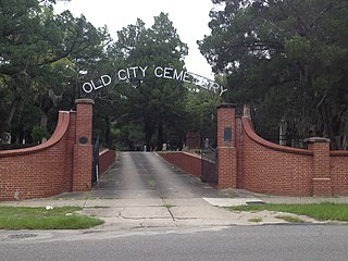
The Old City Cemetery in Jacksonville, Florida was established in 1852 as Jacksonville's main burial ground. After the American Civil War the cemetery later interred many Confederate veterans. Being that the cemetery is over 160 years old the Jacksonville Historic Landmarks Commission has deemed it as a historic landmark of Jacksonville. The United Daughters of the Confederacy improved the cemetery by placing a historical plaque for the cemetery in 1949 and then a wall at the entrance of the cemetery in 1954.
Svoboda is a village in Momchilgrad Municipality, Kardzhali Province, southern Bulgaria.
Ouezzane is a province in the Moroccan region of Tanger-Tetouan-Al Hoceima. It was created in 2009 from parts of Chefchaouen Province and Sidi Kacem Province, and recorded a population of 300,637 in the 2014 Moroccan census. The capital is Ouezzane.
ArcadiaTownship is an inactive township in Iron County, in the U.S. state of Missouri.
Alief Early College High School (AECHS) is a magnet high school in Houston, Texas and a part of the Alief Independent School District, in conjunction with Houston Community College. It was scheduled to open in fall 2009, and 120 spaces were to be available for ninth grade students.


