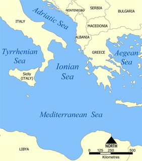
The Ionian Sea is an elongated bay of the Mediterranean Sea, south of the Adriatic Sea. It is bounded by Southern Italy including Calabria, Sicily, and the Salento peninsula to the west, southern Albania to the north, and the west coast of Greece.

Upper Bavaria is one of the seven administrative districts of Bavaria, Germany.
Kareličy is a town in Hrodna Province, Belarus, a raion center.
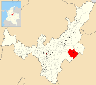
Labranzagrande is a town and municipality in the Colombian Department of Boyacá, part of the subregion of the La Libertad Province.

Cájar is a city located in the province of Granada, Spain. According to the 2005 census (INE), the city has a population of 4051 inhabitants.

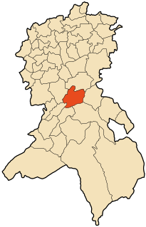
Cuevas de San Clemente is a municipality located in the province of Burgos, Castile and León, Spain. According to the 2004 census (INE), the municipality has a population of 59 inhabitants.
Guarani das Missões is a municipality in the state of Rio Grande do Sul, Brazil.
Fottigue is a town in the Bittou Department of Boulgou Province in south-eastern Burkina Faso. As of 2005, the town has a population of 2,698.
Zame is a village in the Zoaga Department of Boulgou Province in south-eastern Burkina Faso. As of 2005, the village has a population of 829.
Kogoue is a town in the Sidéradougou Department of Comoé Province in south-western Burkina Faso. The town has a population of 1,206.

Carrillo Puerto Municipality is a municipality in Veracruz, Mexico. It is located in the middle of the State of Veracruz. It has a surface of 246.76 km2. It is located at 18°47′N96°34′W.

Titulcia is a municipality of the Community of Madrid, Spain.
Oggaz is a town and commune in Mascara Province, Algeria. According to the 1998 census it has a population of 10,120.
El Kerma is a town and commune in Oran Province, Algeria. According to the 1998 census it has a population of 13637.
Kongaye is a town in the Piéla Department of Gnagna Province in eastern Burkina Faso. The town has a population of 2586.
Telagh is a town and commune in Sidi Bel Abbès Province in north-western Algeria.

Guéckédou or Guékédou is a town in southern Guinea near the Sierra Leone and Liberian borders. It had a population of 79,140 in 1996 (census) but has grown massively since the civil wars and, as of 2008, it is estimated to be 221,715. It was a centre of fighting during the Second Liberian Civil War and the Sierra Leone Civil War in 2000 and 2001.

Weija is a small town and is the capital of Ga South Municipal district, a district in the Greater Accra Region of Ghana. Weija has become a hotspot for economic activity because of the ultra modern shopping center, the West hills mall, which has been built there.
Kumbungu is a town in the Kumbungu District of the Northern Region of Ghana. As of 2010, fertility rate in Kumbungu stood at 3.6 and had a total population of 39,341 with an almost equal ratio of females to males.

The Soviet Republic of Saxony was a short-lived, unrecognised socialist state during the German Revolution of 1918–19.


