
Geoffroy's cat is a wild cat native to the southern and central regions of South America. It is about the size of a domestic cat. It is listed as Least Concern on the IUCN Red List because it is widespread and abundant over most of its range.

Wymeswold is a village and civil parish in the Charnwood district of Leicestershire, England. It is in the north of Leicestershire, and north-east of Loughborough. The village has a population of about 1,000, measured at 1,296 in the 2011 census. It is close to Prestwold and Burton on the Wolds in Leicestershire, and the Nottinghamshire villages of Rempstone and Willoughby on the Wolds.
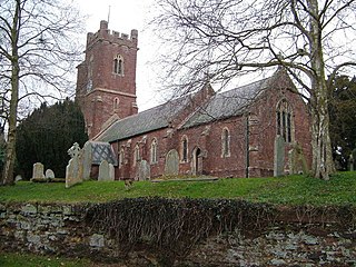
Sowton is a village and civil parish east of Exeter in East Devon, England. It has a population of 639.

St Nicholas Church is a Church of England parish church in Worth, a village in Crawley, England which at one time had the largest geographical parish in England.

Willesden railway station was a station about 50 yards (46 m) north of Acton Lane level crossing in Harlesden, north-west London, opened in 1841 by the London and Birmingham Railway (L&BR) on what became the West Coast Main Line (WCML). It had wooden platforms about 50 yards (46 m) long beside each of the two tracks, a small wooden ticket office with an awning and a coal siding. It was five or six furlongs south of the original village of Willesden, in what is now the London Borough of Brent. It closed later the same year, reopened in 1844 and closed finally when the L&BR's successor, the London and North Western Railway (LNWR), opened Willesden Junction station about 0.5 miles (0.80 km) to the south east on 1 September 1866. On 15 June 1912 the LNWR opened a new station, "Harlesden". near the site.

John Winchester Dana was an American businessman and Democratic politician in the U.S. state of Maine. He served as the 19th and 21st Governor of Maine and as Chargé d'affaires to Bolivia during the 19th century.

Cosperville is an unincorporated community in Elkhart Township, Noble County, in the U.S. state of Indiana.
Brewersville is an unincorporated community in Sand Creek Township, Jennings County, Indiana.
Monoquet is an unincorporated community in Plain Township, Kosciusko County, in the U.S. state of Indiana.
Ballstown is an unincorporated community in Laughery Township, Ripley County, in the U.S. state of Indiana.
Bourzoaga is a small village in the Bittou Department of Boulgou Province in south-eastern Burkina Faso. As of 2005, the village has a population of 17.
Mogande-Peulh is a village in the Bittou Department of Boulgou Province in south-eastern Burkina Faso. As of 2005, the village has a population of 350.
Sampa is a village in the Tenkodogo Department of Boulgou Province in south-eastern Burkina Faso. As of 2005, the village has a population of 684.
Gon, Burkina Faso is a village in the Zabré Department of Boulgou Province in south-eastern Burkina Faso. As of 2005, the village has a population of 810.
Youkouka is a village in the Zabré Department of Boulgou Province in south-eastern Burkina Faso. As of 2005, the village has a population of 374.
Zame is a village in the Zoaga Department of Boulgou Province in south-eastern Burkina Faso. As of 2005, the village has a population of 829.
Dobwalls and Trewidland is a civil parish in south-east Cornwall, England, United Kingdom.

Loxhore is a small village, civil parish and former manor in the local government district of North Devon in the county of Devon, England. The parish, which lies about five miles north-east of the town of Barnstaple, is surrounded clockwise from the north by the parishes of Arlington, Bratton Fleming and Shirwell. In 2001 its population was 153, down from the 202 residents it had in 1901.
Negangards Corner is an unincorporated community in Franklin Township, Ripley County, in the U.S. state of Indiana.
Behlmer Corner is an unincorporated community in Franklin Township, Ripley County, in the U.S. state of Indiana.


