Dierma | |
|---|---|
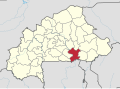
 Interactive map of Dierma | |
| Country | |
| Region | Centre-Est Region |
| Province | Boulgou Province |
| Department | Boussouma Department |
| Population (2005 est.) | |
• Total | 2,446 |
Dierma is a town in the Boussouma Department of Boulgou Province in south-eastern Burkina Faso. As of 2005, the town has a population of 2446. [1]