Black Run (Paxton Creek tributary)

Last updated

Black Run [1] is a 3.9-mile-long (6.3 km) [2] tributary of Paxton Creek in Dauphin County, Pennsylvania, in the United States.

Tributary stream or river that flows into a main stem river or lake

A tributary or affluent is a stream or river that flows into a larger stream or main stem river or a lake. A tributary does not flow directly into a sea or ocean. Tributaries and the main stem river drain the surrounding drainage basin of its surface water and groundwater, leading the water out into an ocean.

Paxton Creek tributary of the Susquehanna River in Pennsylvania, United States

Paxton Creek is a 13.9-mile-long (22.4 km) tributary of the Susquehanna River in Dauphin County, Pennsylvania in the United States.

Dauphin County, Pennsylvania County in the United States

Dauphin County is a county in the U.S. state of Pennsylvania. As of the 2010 census, the population was 268,100. The county seat and the largest city is Harrisburg, Pennsylvania's state capital and tenth largest city. The county was created ("erected") on March 4, 1785, from part of Lancaster County and was named after Louis-Joseph, Dauphin of France, the first son of king Louis XVI.

Black Run begins in upper Susquehanna Township and joins Paxton Creek 6.3 miles (10.1 km) from the Susquehanna at Harrisburg.

Susquehanna Township, Dauphin County, Pennsylvania Township in Pennsylvania, United States

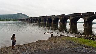
Susquehanna Township is a township in Dauphin County, Pennsylvania, United States. The population was 24,036 at the 2010 census. This represents a 9.8% increase from the 2000 census count of 21,895. Susquehanna Township has the postal ZIP codes 17109 and 17110, which maintain the Harrisburg place name designation. The township is a suburb of Harrisburg and is connected to Marysville by the Rockville Bridge, the world's longest stone-arch rail bridge at the time of its completion.

Susquehanna River river in the northeastern United States

The Susquehanna River is a major river located in the northeastern and mid-Atlantic United States. At 464 miles (747 km) long, it is the longest river on the East Coast of the United States that drains into the Atlantic Ocean. With its watershed, it is the 16th-largest river in the United States, and the longest river in the early 21st-century continental United States without commercial boat traffic.

See also

Related Research Articles

Stony Creek is a 23.0-mile-long (37.0 km) tributary of the Susquehanna River in Dauphin County, Pennsylvania, in the United States.

Penns Creek tributary of the Susquehanna River in Pennsylvania

Penns Creek is a 67.1-mile-long (108.0 km) tributary of the Susquehanna River in central Pennsylvania in the United States.

Middle Creek (Penns Creek tributary) tributary of Penns Creek in Snyder County, Pennsylvania, US

Middle Creek is a 31.7-mile-long (51.0 km) tributary of Penns Creek in Snyder County, Pennsylvania in the United States. Via Penns Creek, it is part of the Susquehanna River watershed.

Little Conestoga Creek is a 21.1-mile-long (34.0 km) tributary of the Conestoga River in Pennsylvania. The Landis Mill Covered Bridge crosses the creek.

Conowingo Creek is a 20.2-mile-long (32.5 km) tributary of the Susquehanna River in Lancaster County, Pennsylvania and Cecil County, Maryland.

Chiques Creek river in the United States of America

Chiques Creek is a 31.6-mile-long (50.9 km) tributary of the Susquehanna River in Lebanon and Lancaster counties, Pennsylvania in the United States.

Cocalico Creek river in the United States of America

Cocalico Creek is a 27.2-mile-long (43.8 km) tributary of the Conestoga River in Lebanon and Lancaster counties in Pennsylvania in the United States. The source is at an elevation of 1,320 feet (400 m) near Stricklerstown in Millcreek Township, Lebanon County. The mouth is the confluence with the Conestoga River at an elevation of 278 feet (85 m) at Talmage in West Earl Township, Lancaster County.

Little Clearfield Creek is a 14.5-mile-long (23.3 km) tributary of Clearfield Creek in Clearfield County, Pennsylvania in the United States.

Sugar Creek is a 32.0-mile-long (51.5 km) tributary of the Susquehanna River in Bradford County, Pennsylvania in the United States.

Tucquan Creek river in the United States of America

Tucquan Creek is a 5.9-mile-long (9.5 km) stream and tributary of the Susquehanna River near Holtwood in southern Lancaster County, Pennsylvania. Together with parts of Clark Run and Tucquan Glen it is a designated Pennsylvania Scenic River. The Tucquan Glen hiking trail goes along both sides of the creek, starting from River Road and ending at the railroad tracks along the Susquehanna. In addition to the rugged loop trail, is a relatively flat dirt road going along and often crossing the creek to said railroad tracks.

Mahantango Creek is a 36.2-mile-long (58.3 km) tributary of the Susquehanna River in Dauphin, Northumberland, Schuylkill, and Snyder County counties, Pennsylvania in the United States.

Powell Creek is a 16.5-mile-long (26.6 km) tributary of the Susquehanna River in Dauphin County, Pennsylvania in the United States.

Fishing Creek is an 11.5-mile-long (18.5 km) tributary of the Susquehanna River in Dauphin County, Pennsylvania, in the United States.

Little Chiques Creek is a 20.6-mile-long (33.2 km) tributary of Chiques Creek in Lancaster County, Pennsylvania in the United States.

Muddy Creek is a tributary of the Susquehanna River in York County, Pennsylvania, in the United States.

Asylum Run is a 4.2-mile-long (6.8 km) tributary of Paxton Creek in Dauphin County, Pennsylvania in the United States.

Conoy Creek is an 11.2-mile-long (18.0 km) tributary of the Susquehanna River in Lancaster County, Pennsylvania in the United States.

Muddy Creek is a 15.7-mile-long (25.3 km) tributary of the Conestoga River in Lancaster County, Pennsylvania, in the United States.

Spring Creek is a 6.0-mile-long (9.7 km) tributary of the Susquehanna River in Dauphin County, Pennsylvania, in the United States.

References

  1. U.S. Geological Survey Geographic Names Information System: Black Run (Paxton Creek tributary)
  2. U.S. Geological Survey. National Hydrography Dataset high-resolution flowline data. The National Map Archived 2012-04-05 at WebCite , accessed August 8, 2011

Coordinates: 40°18′25″N76°52′13″W / 40.30706°N 76.87029°W / 40.30706; -76.87029

Geographic coordinate system Coordinate system

A geographic coordinate system is a coordinate system that enables every location on Earth to be specified by a set of numbers, letters or symbols. The coordinates are often chosen such that one of the numbers represents a vertical position and two or three of the numbers represent a horizontal position; alternatively, a geographic position may be expressed in a combined three-dimensional Cartesian vector. A common choice of coordinates is latitude, longitude and elevation. To specify a location on a plane requires a map projection.