Spruce Creek (Pennsylvania)

Last updated

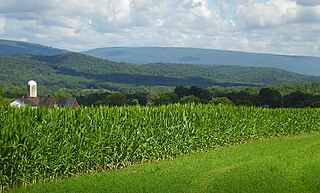
Spruce Creek is a 16.5-mile-long (26.6 km) [1] tributary of the Little Juniata River in Huntingdon County, Pennsylvania in the United States. [2] [3]

Tributary stream or river that flows into a main stem river or lake

A tributary or affluent is a stream or river that flows into a larger stream or main stem river or a lake. A tributary does not flow directly into a sea or ocean. Tributaries and the main stem river drain the surrounding drainage basin of its surface water and groundwater, leading the water out into an ocean.

Little Juniata River tributary of the Juniata River in Pennsylvania, United States

The Little Juniata River, sometimes called the "Little J," is a river that is not owned by anyone person. It is held in trust by the state of Pennsylvania for the people of the state and beyond. Pennsylvania. 32.1-mile-long (51.7 km) tributary of the Juniata River in the Susquehanna River watershed. It is formed at Altoona by the confluence of several short streams. It flows northeast in the Logan Valley at the foot of Brush Mountain.

Huntingdon County, Pennsylvania county in Pennsylvania, United States

Huntingdon County is a county located in the center of the U.S. state of Pennsylvania. As of the 2010 census, the population was 45,913. Its county seat is Huntingdon. The county was created on September 20, 1787, mainly from the north part of Bedford County, plus an addition of territory on the east from Cumberland County.

Contents

Spruce Creek passes by Indian Caverns several miles before joining the Little Juniata River at the village of Spruce Creek. [3]

Indian Caverns cave in United States of America

Indian Caverns was a show cave in Spruce Creek, Pennsylvania, United States from 1929-2017. It is a horizontal karst cave of Ordovician Nealmont/Benner limestone, estimated to be about 500,000 years old. It is the second-largest cave in Pennsylvania and the largest limestone cave. Indian Caverns consists of two sections, originally separated by a 14-foot wall: the "Historic Cave" and the "Giant's Hall". The "historic" part of the cave is generally low-ceilinged and closer to the surface with a couple of wide rooms and extensive speleothem formation. The Giant's Hall area consists of several large passageways, up to 60 feet high, but with fewer speleothems - though it does include the largest sheet of flowstone in the northeast and a substantial rimstone pool. The lowest point of the cave is approximately 140 feet beneath the surface and the cave temperature is a constant 56 degrees Fahrenheit.

Spruce Creek, Pennsylvania Unincorporated community in Pennsylvania, United States

Spruce Creek is a small unincorporated community in Spruce Creek Township of Huntingdon County, Pennsylvania, United States. It was a stop on the former Pennsylvania Railroad Main Line, lying along Spruce Creek at its confluence with the Little Juniata River. The river passes through a nearby water gap in Tussey Mountain downstream of the village, along with the railroad line.

Located on Spruce Creek is the elite 100 member Spruce Creek Rod and Gun Club. Notable members include former president Jimmy Carter.

Jimmy Carter 39th President of the United States

James Earl Carter Jr. is an American politician and philanthropist who served as the 39th president of the United States from 1977 to 1981. A Democrat, he previously served as a Georgia State senator from 1963 to 1967 and as the 76th governor of Georgia from 1971 to 1975. Carter has remained active in public life during his post-presidency, and in 2002 he was awarded the Nobel Peace Prize for his work in co-founding the Carter Center.

See also

Related Research Articles

Aughwick Creek is a 30.8-mile-long (49.6 km) tributary of the Juniata River in Huntingdon County, Pennsylvania in the United States.

Bald Eagle Creek is a 9.4-mile-long (15.1 km) tributary of the Little Juniata River in Blair County, Pennsylvania, in the United States. It runs southwest through the Bald Eagle Valley at the foot of the Bald Eagle Mountain ridge to Tyrone.

Yellow Creek is a 20.9-mile-long (33.6 km) tributary of the Raystown Branch Juniata River in Bedford County, Pennsylvania, in the United States.

Bobs Creek is a tributary of Dunning Creek in south west/south central Pennsylvania in the United States.

Dunning Creek is a 27.8-mile-long (44.7 km) tributary of the Raystown Branch Juniata River in south west/south central Pennsylvania in the United States.

Frankstown Branch Juniata River river in the United States of America

The Frankstown Branch Juniata River is a 46.0-mile-long (74.0 km) tributary of the Juniata River in Blair and Huntingdon Counties, Pennsylvania, in the United States.

Clover Creek is a 24.5-mile-long (39.4 km) tributary of the Frankstown Branch Juniata River in Bedford and Blair counties, Pennsylvania, in the United States.

Brush Creek is a 24.7-mile-long (39.8 km) tributary of the Raystown Branch Juniata River in Fulton and Bedford counties, Pennsylvania, in the United States.

Raystown Branch Juniata River river in the United States of America

The Raystown Branch Juniata River is the largest and longest tributary of the Juniata River in south-central Pennsylvania in the United States.

Lost Creek is a 17.5-mile-long (28.2 km) tributary of the Juniata River in central Pennsylvania in the United States.

Tuscarora Creek is a 49.2-mile-long (79.2 km) tributary of the Juniata River in central Pennsylvania in the United States. It rises in eastern Huntingdon County, east of the borough of Shade Gap, and flows northeast between Tuscarora Mountain and Shade Mountain, reaching the Juniata River at Port Royal in Juniata County.

Little Aughwick Creek is a 10.8-mile-long (17.4 km) tributary of Aughwick Creek in Fulton and Huntingdon counties, Pennsylvania in the United States.

Buffalo Creek is a 31.4-mile-long (50.5 km) tributary of the Juniata River in Perry County, Pennsylvania, in the United States.

Shaver's Creek is a 19.6-mile-long (31.5 km) tributary of the Juniata River in Huntingdon County, Pennsylvania in the United States.

Mahantango Creek is a 36.2-mile-long (58.3 km) tributary of the Susquehanna River in Dauphin, Northumberland, Schuylkill, and Snyder County counties, Pennsylvania in the United States.

Snare Run is a 1.6-mile-long (2.6 km) tributary of the lower reaches of Clover Creek in Pennsylvania in the United States. Via Clover Creek, its waters flow to the Frankstown Branch Juniata River, the Juniata River itself, the Susquehanna River, and eventually Chesapeake Bay.

Cocolamus Creek is a 22.1-mile-long (35.6 km) tributary of the Juniata River in Juniata and Perry counties, Pennsylvania in the United States.

Honey Creek is a 20.3-mile-long (32.7 km) tributary of Kishacoquillas Creek in Mifflin County, Pennsylvania in the United States.

Kishacoquillas Creek is a 24.0-mile-long (38.6 km) tributary of the Juniata River in Mifflin County, Pennsylvania in the United States.

References

  1. U.S. Geological Survey. National Hydrography Dataset high-resolution flowline data. The National Map, accessed August 8, 2011
  2. U.S. Geological Survey Geographic Names Information System: Spruce Creek (Pennsylvania)
  3. 1 2 Gertler, Edward. Keystone Canoeing, Seneca Press, 2004. ISBN   0-9749692-0-6

Coordinates: 40°36′31″N78°08′09″W / 40.60861°N 78.13583°W / 40.60861; -78.13583

Geographic coordinate system Coordinate system

A geographic coordinate system is a coordinate system that enables every location on Earth to be specified by a set of numbers, letters or symbols. The coordinates are often chosen such that one of the numbers represents a vertical position and two or three of the numbers represent a horizontal position; alternatively, a geographic position may be expressed in a combined three-dimensional Cartesian vector. A common choice of coordinates is latitude, longitude and elevation. To specify a location on a plane requires a map projection.