
Lycoming County is a county in the Commonwealth of Pennsylvania. As of the 2020 census, the population was 114,188. Its county seat is Williamsport. The county is part of the North-Central Pennsylvania region of the state.

Franklin Township is a township in Lycoming County, Pennsylvania, United States. The population was 901 at the 2020 census. It is part of the Williamsport Metropolitan Statistical Area.
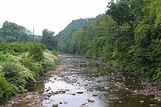
Muncy Creek is a tributary of the West Branch Susquehanna River in Sullivan County and Lycoming County, at Pennsylvania, in the United States. It is approximately 34.5 miles (55.5 km) long. The watershed of the creek has an area of 216 square miles (560 km2). The creek's discharge averages 49 cubic feet per second (1.4 m3/s) at Sonestown, but can be up to a thousand times higher at Muncy. The headwaters of the creek are on the Allegheny Plateau. Rock formations in the watershed include the Chemung Formation and the Catskill Formation.

Lycoming Creek is a 37.5-mile-long (60.4 km) tributary of the West Branch Susquehanna River located in Tioga and Lycoming counties in Pennsylvania in the United States.

Larrys Creek is a 22.9-mile-long (36.9 km) tributary of the West Branch Susquehanna River in Lycoming County in the U.S. state of Pennsylvania. A part of the Chesapeake Bay drainage basin, its watershed drains 89.1 square miles (231 km2) in six townships and a borough. The creek flows south from the dissected Allegheny Plateau to the Ridge-and-valley Appalachians through sandstone, limestone, and shale from the Devonian, Mississippian, and Pennsylvanian periods.

Loyalsock Creek is a 64-mile-long (103 km) tributary of the West Branch Susquehanna River located chiefly in Sullivan and Lycoming counties in Pennsylvania in the United States. As the crow flies, Lycoming County is about 130 miles (209 km) northwest of Philadelphia and 165 miles (266 km) east-northeast of Pittsburgh.

White Deer Hole Creek is a 20.5-mile (33.0 km) tributary of the West Branch Susquehanna River in Clinton, Lycoming and Union counties in the U.S. state of Pennsylvania. A part of the Chesapeake Bay drainage basin, the White Deer Hole Creek watershed drains parts of ten townships. The creek flows east in a valley of the Ridge-and-valley Appalachians, through sandstone, limestone, and shale from the Ordovician, Silurian, and Devonian periods.

Little Loyalsock Creek is the major tributary of Loyalsock Creek in Lycoming and Sullivan counties, Pennsylvania, United States. The creek is 19.3 miles (31.1 km) long. Via Loyalsock Creek and the West Branch Susquehanna River, it is part of the Susquehanna River drainage basin, and waters from it flow ultimately into the Chesapeake Bay.
Schrader Creek is a tributary of Towanda Creek in Sullivan County and Bradford County, in Pennsylvania, in the United States. It is approximately 23.4 miles (37.7 km) long and flows through Fox Township in Sullivan County and Leroy Township, Franklin Township, and Monroe Township in Bradford County.

Little Fishing Creek is a tributary of Fishing Creek in Sullivan County, Lycoming County, and Columbia County, in Pennsylvania, in the United States. It is approximately 23.5 miles (37.8 km) long and flows through eight townships. The watershed of the creek has an area of 68.1 square miles (176 km2). The creek has six named tributaries, of which the largest are Spruce Run and West Branch Run.

Plunketts Creek is an approximately 6.2-mile-long (10 km) tributary of Loyalsock Creek in Lycoming and Sullivan counties in the U.S. state of Pennsylvania. Two unincorporated villages and a hamlet are on the creek, and its watershed drains 23.6 square miles (61 km2) in parts of five townships. The creek is a part of the Chesapeake Bay drainage basin via Loyalsock Creek and the West Branch Susquehanna and Susquehanna Rivers.

Shingle Run is a tributary of West Branch Run in Lycoming County and Columbia County, in Pennsylvania, in the United States. It is approximately 2.5 miles (4.0 km) long and flows through Jordan Township, Lycoming County and Pine Township, Columbia County. Its watershed has an area of 1.63 square miles (4.2 km2) and the stream has various unnamed tributaries. At least one bridge crosses the stream. The stream is inhabited by trout. It is named after nearby sawmills.

Turkey Run is a tributary of the West Branch Susquehanna River in Lycoming County, Pennsylvania, in the United States. It is approximately 2.2 miles (3.5 km) long and flows through Clinton Township. The watershed of the stream has an area of 2.18 square miles (5.6 km2). The stream is not designated as an impaired waterbody. It is a relatively small stream and is located near State Correctional Institution – Muncy. The stream's watershed is designated as a Warmwater Fishery and a Migratory Fishery.

Glade Run is a tributary of the West Branch Susquehanna River in Northumberland County and Lycoming County, in Pennsylvania, in the United States. It is approximately 6.5 miles (10.5 km) long and flows through Lewis Township in Northumberland County and Muncy Creek Township and Muncy in Lycoming County. The watershed of the stream has an area of 7.63 square miles (19.8 km2). The stream is not designated as an impaired waterbody. An Indian path known as the Wyoming Path was historically in the stream's vicinity. More recently, a number of bridges have been constructed over Glade Run. The stream's watershed is designated as a Warmwater Fishery and a Migratory Fishery.

Shepman Run is a tributary of Little Muncy Creek in Lycoming County, Pennsylvania, in the United States. It is approximately 2.6 miles (4.2 km) long and flows through Moreland Township. The watershed of the stream has an area of 1.59 square miles (4.1 km2). A covered bridge crosses the stream. Shepman Run is classified as a Coldwater Fishery and a Migratory Fishery.
Little Indian Run is a tributary of Little Muncy Creek in Lycoming County and Sullivan County, in Pennsylvania, in the United States. It is approximately 4.3 miles (6.9 km) long and flows through Franklin Township and Jordan Township in Lycoming County and Davidson Township in Sullivan County. The watershed of the stream has an area of 3.36 square miles (8.7 km2). The surficial geology in the stream's vicinity mainly consists of alluvium, bedrock, Wisconsinan Till, Wisconsinan Till Moraine, and Wisconsinan Ice-Contact Stratified Drift. Wild trout naturally reproduce within the stream. A number of sawmills were historically located on the stream.

Beaver Run is a tributary of Little Muncy Creek in Sullivan County and Lycoming County, in Pennsylvania, in the United States. It is approximately 7.9 miles (12.7 km) long and flows through Davidson Township in Sullivan County and Penn Township and Franklin Township in Lycoming County. The watershed of the stream has an area of 12.7 square miles (33 km2). The stream is dammed by the Beaver Lake Dam and a number of bridges have been constructed across it. Beaver Run has one named tributary, which is known as Marsh Run.

Big Run is a tributary of Little Muncy Creek in Lycoming County, Pennsylvania, in the United States. It is approximately 4.3 miles (6.9 km) long and flows through Penn Township and Franklin Township. The watershed of the stream has an area of 3.99 square miles (10.3 km2). The stream is impaired by a high total concentration of nitrogen. A number of bridges have been constructed across it.

Derr Run is a tributary of Little Muncy Creek in Lycoming County, Pennsylvania, in the United States. It is approximately 2.9 miles (4.7 km) long and flows through Penn Township and Franklin Township. The watershed of the stream has an area of 1.61 square miles (4.2 km2). It is classified as a Coldwater Fishery and a Migratory Fishery.
Laurel Run is a tributary of Little Muncy Creek in Columbia County and Lycoming County, in Pennsylvania, in the United States. It is approximately 6.8 miles (10.9 km) long and flows through Madison Township and Pine Township in Columbia County and Franklin Township and Moreland Township in Lycoming County. The watershed of the stream has an area of 12.2 square miles (32 km2). It is classified as a Coldwater Fishery and a Migratory Fishery. A number of bridges have been constructed over the stream.


