Related Research Articles

Scouting in Maryland has a long history, from the 1910s to the present day, serving millions of youth with activities that have adapted to the changing cultural environment but have always been rooted in an active outdoor program.

The Susquehanna River is a major river located in the northeastern and mid-Atlantic United States. At 444 miles (715 km) long, it is the longest river on the East Coast of the United States. It drains into the Chesapeake Bay. With its watershed, it is the 16th-largest river in the United States, and the longest river in the early 21st-century continental United States without commercial boat traffic.

The Juniata River is a tributary of the Susquehanna River, approximately 104 miles (167 km) long, in central Pennsylvania in the United States. The river is considered scenic along much of its route, having a broad and shallow course passing through several mountain ridges and steeply-lined water gaps. It formed an early 18th-century frontier region in Pennsylvania and was the site of Native American attacks against white settlements during the French and Indian War. The watershed of the river encompasses an area of approximately 3,400 square miles (8,800 km2), approximately one-eighth of the drainage area of the Susquehanna. Approximately two-thirds of the watershed is forested. It is the second largest tributary of the Susquehanna after the West Branch Susquehanna.

The Tioga River is a tributary of the Chemung River, approximately 58 miles (93 km) long, in northern Pennsylvania and western New York in the United States. It drains a region of ridges in the northern Allegheny Plateau in the watershed of the Susquehanna River. It is a Northern flowing river
The Otselic River(aht-SEEL-ik), formerly known as Otselic Creek is a 55.4-mile-long (89.2 km) tributary of the Tioughnioga River in central New York in the United States. It drains a hilly area, mostly forested and agricultural, east of the Finger Lakes at the northern edge of the Susquehanna River watershed.
The Gunpowder River is a 6.8-mile-long (10.9 km) tidal inlet on the western side of Chesapeake Bay in Maryland, United States. It is formed by the joining of two freshwater rivers, Gunpowder Falls and Little Gunpowder Falls.

The Conestoga River, also referred to as Conestoga Creek, is a 61.6-mile-long (99.1 km) tributary of the Susquehanna River flowing through the center of Lancaster County, Pennsylvania, United States.

Darlington is an unincorporated community and census-designated place in northeastern Harford County, Maryland, United States. The population was 409 at the 2010 census. The center of the community was listed on the National Register of Historic Places as the Darlington Historic District in 1987. Median household income is $66,563. The percentage of people in poverty is 5.3%.

Maryland Route 7 (MD 7) is a collection of state highways in the U.S. state of Maryland. Known for much of their length as Philadelphia Road, there are five disjoint mainline sections of the highway totaling 40.23 miles (64.74 km) that parallel U.S. Route 40 (US 40) in Baltimore, Harford, and Cecil counties in northeastern Maryland. The longest section of MD 7 begins at US 40 just east of the city of Baltimore in Rosedale and extends through eastern Baltimore County and southern Harford County to US 40 in Aberdeen. The next segment of the state highway is a C-shaped route through Havre de Grace on the west bank of the Susquehanna River. The third mainline section of MD 7 begins in Perryville on the opposite east bank of the Susquehanna River and ends at US 40 a short distance west of the start of the fourth section, which passes through Charlestown and North East before ending at US 40, just west of Elkton. The fifth segment of the highway begins at South Street and passes through the eastern part of Elkton before reconnecting with US 40 just west of the Delaware state line.
Crooked Creek is a 26.3-mile-long (42.3 km) tributary of the Tioga River located entirely in Tioga County, Pennsylvania in the United States.

Octoraro Creek is a 22.1-mile-long (35.6 km) tributary of the Susquehanna River, joining it 9 miles (14 km) above the Susquehanna's mouth at Chesapeake Bay. The Octoraro rises as an East and West Branch in Pennsylvania. The East Branch and Octoraro Creek form the southern half of the border between Lancaster and Chester counties until the creek crosses the Mason-Dixon line. It winds through northwestern Cecil County, Maryland before joining the Susquehanna.

Conewago Creek is an 80.2-mile-long (129.1 km) tributary of the Susquehanna River in Adams and York counties in Pennsylvania in the United States, with its watershed also draining a small portion of Carroll County, Maryland. The source is at an elevation of 1,440 feet (440 m), east of Caledonia State Park, in Franklin Township in Adams County. The mouth is the confluence with the Susquehanna River at York Haven in York County at an elevation of 259 feet (79 m).
Codorus Creek is a 42.4-mile-long (68.2 km) tributary of the Susquehanna River in York County, Pennsylvania in the United States.
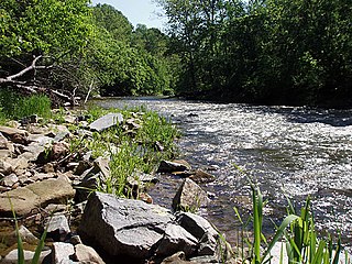
Deer Creek is a 52.9-mile-long (85.1 km) river in Maryland and Pennsylvania that flows through the scenic areas of Harford County and empties into the Susquehanna River, roughly halfway between the Interstate 95 bridge and Conowingo Dam. Its watershed area is 171 square miles (440 km2). Its watershed area in MD is 145 square miles (380 km2), with 3% impervious surface in 1994. It serves as a divider between the agricultural and urban/suburban areas of Harford County.

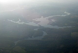
Broad Creek Memorial Scout Reservation, more commonly called just Broad Creek, is the sum of eight separate areas in the Chesapeake Bay Watershed. The reservation is 3 miles (4.8 km) from the Maryland and Pennsylvania border within Harford County, 25 miles (40 km) from the Maryland and Delaware border, and 28 miles (45 km) from Baltimore. During the summer Camp Saffran focuses on older youth while Camp Spencer focuses on younger youth. Camp Oest was focused on younger youth, but that operation moved to Camp Spencer in 2016. Camp Oest is now used for large events, such as Woodbadge and NYLC. During the off-season Camp Oest, Camp Saffran, and Camp Spencer are open for weekend tent and cabin camping. Five other less developed areas of the reservation used for outpost camping and hiking are called Camp Cone, Camp Finney, The Pines, The Hemlocks, and OA Hill. The facilities at the reservation are used by 36,000 youth each year, 17% of whom are not affiliated with the Boy Scouts of America.

Maryland Route 136 is a state highway in the U.S. state of Maryland. The state highway runs 30.04 miles (48.34 km) from MD 7 near Abingdon north to MD 23 in Norrisville. MD 136 is an L-shaped route that connects the communities of Creswell, Churchville, Dublin, and Whiteford in eastern Harford County with each other and with Norrisville in the county's northwestern corner. The state highway is connected to the cities of Aberdeen and Havre de Grace via its connection with MD 22. MD 136 is also linked to the county seat of Bel Air from the east through MD 22, from the northeast by U.S. Route 1, from the north via MD 24, and from the northwest by MD 23. The state highway starts on the coastal plain near the Chesapeake Bay and crosses Harford County's two main tributaries of the Susquehanna River, Deer Creek and Broad Creek, while traversing a wide swath of the Piedmont. MD 136 is the second longest Maryland state highway entirely within one county after MD 235.
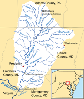
Double Pipe Creek, sometimes called Pipe Creek, is a major tributary of the Monocacy River in Carroll County and Frederick County in Maryland, located several miles north and west of Westminster. The creek is only 1.6 miles (2.6 km) long, but is formed by the confluence of two much longer streams, Big Pipe Creek and Little Pipe Creek.
Winters Run is a 14.6-mile-long (23.5 km) river in Harford County, Maryland. The river begins north of the community of Fallston at the confluence of the West and East Branches, and flows southeast about 11 miles (18 km) to Atkisson Dam in Edgewood. The dam and reservoir were built by the U.S. Army in 1942 to provide an auxiliary fresh water source for nearby Edgewood Arsenal. Upon reaching the tidal line, the river is renamed Otter Point Creek, which empties to Bush River and the Chesapeake Bay. The watershed area of Winters Run is about 56 square miles (150 km2).
Partners Creek is a tributary of Tunkhannock Creek in Susquehanna County, Pennsylvania, in the United States. It is approximately 6.4 miles (10.3 km) long and flows through Harford Township and Lenox Township. The watershed of the creek has an area of 5.84 square miles (15.1 km2). The creek has one named tributary, which is known as Sterling Brook. The drainage basin of Partners Creek is classified as a Coldwater Fishery and a Migratory Fishery. The surficial geology in the vicinity of the creek consists of Wisconsinan Till, alluvium, bedrock, wetlands, lakes, and alluvial fan.
Nine Partners Creek is a tributary of Tunkhannock Creek in Susquehanna County, Pennsylvania, in the United States. It is approximately 10 miles (16 km) long and flows through New Milford Township, Harford Township, and Lenox Township. The watershed of the creek has an area of 38.6 square miles (100 km2). The creek has two named tributaries: Butler Creek and Leslie Creek. The surficial geology in the vicinity of Nine Partners Creek includes Wisconsinan Till, alluvium, bedrock, alluvial fan, and wetlands. The creek's drainage basin is designated as a Coldwater Fishery and a Migratory Fishery.
References
- ↑ U.S. Geological Survey. National Hydrography Dataset high-resolution flowline data. The National Map Archived 2012-04-05 at WebCite , accessed August 8, 2011
- ↑ Lake Straus: "Baltimore Speeds Scout Camp Work". Washington Post. Jul 22, 1947.:B1Healey, David (Sep 18, 2012). Great Storms of the Chesapeake. Arcadia. p. 160.
- ↑ U.S. Department of Agriculture U.S. National Forest Service. Northeast Area. , accessed March 1, 2013
- ↑ Maryland Department of Natural Resources. Annapolis, MD. "Broad Creek." Archived June 16, 2011, at the Wayback Machine Maryland's Surf Your Watershed--Watershed Profile. August 2000.
- United States Geological Survey. Reston, VA. "Broad Creek." Geographic Names Information System (GNIS). Accessed 2010-08-30.


