Blanchard, Missouri | |
|---|---|
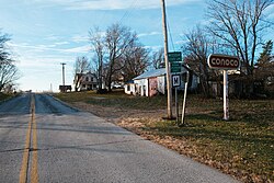 Missouri State Line entering South Blanchard | |
| Nickname: South Blanchard | |
 Blanchard | |
| Coordinates: 40°34′30″N95°12′40″W / 40.57500°N 95.21111°W | |
| Country | |
| State | |
| County | Atchison |
| Township | Lincoln |
| Area | |
• Total | 0.53 sq mi (1.37 km2) |
| • Land | 0.53 sq mi (1.37 km2) |
| • Water | 0 sq mi (0.00 km2) |
| Elevation | 1,034 ft (315 m) |
| Population (2021 estimate) [3] | |
• Total | 31 |
| • Density | 58.6/sq mi (22.63/km2) |
| Time zone | UTC-6 (Central (CST)) |
| • Summer (DST) | UTC-5 (CDT) |
| Area code | 660 |
| GNIS feature ID | 2587055 [2] |
Blanchard is a census-designated place (CDP) in Atchison County, Missouri, United States. As of a 2021 estimate, its population was 31. [4] The community is located on the Iowa border and is adjacent to the city of Blanchard, Iowa. [5] It has sometimes been known as "South Blanchard". [6]
