Screven County is a county located in the southeastern part of the U.S. state of Georgia. As of the 2020 census, the population was 14,067. The county seat is Sylvania.

Effingham County is a county located in the southeastern part of the U.S. state of Georgia. As of the 2020 census, the population was 64,769. The seat is Springfield.

Chatham County is located in the U.S. state of Georgia, on the state's Atlantic coast. The county seat and largest city is Savannah. One of the original counties of Georgia, Chatham County was created February 5, 1777, and is named after William Pitt, 1st Earl of Chatham.

Pembroke is a city and county seat in Bryan County, Georgia, United States. As of the 2020 census, the population of the city was 2,513. It is located approximately 35 miles west of Savannah, Georgia, and approximately 20 miles south of Statesboro, Georgia. Pembroke is part of the Savannah metropolitan statistical area.

Sardis is a city in Burke County, Georgia, United States. The population is 995 in 2020. It is part of the Augusta, Georgia metropolitan area in the Central Savannah River Area (CSRA).

Garden City is a city in Chatham County, Georgia, United States, located just northwest of Savannah. As of the 2020 census, the city had a population of 10,289. Part industrial and part residential, the city is home to much of the heavy industry in Chatham County. It hosts the largest and busiest ocean terminal of the Port of Savannah, the flagship operation of the Georgia Ports Authority.

Georgetown is an unincorporated community and census-designated place (CDP) in Chatham County, Georgia, United States. The population was 11,916 at the 2020 U.S. census. Georgetown lies across the Little Ogeechee River from Savannah, Georgia, and is a suburban "bedroom community" of Savannah, where most of its adult residents work. It is part of the Savannah Metropolitan Statistical Area.

Montgomery is an unincorporated community and census-designated place (CDP) in Chatham County, Georgia, United States. The population was 4,443 at the 2020 United States census, down slightly from 4,523 in 2010. It is a suburb of Savannah and is part of the Savannah metropolitan area.

Pooler is a city in Chatham County, Georgia, United States. According to the official 2020 U.S. census, the population was 25,711, up 34.3% from the 2010 population of 19,140. Pooler is located northwest of Savannah along Interstates 95 and 16. It comprises part of the Savannah metropolitan area.

Port Wentworth is a city in Chatham County, Georgia, United States. The 2020 population was 10,878, more than double the population of 5,359 at the 2010 census. Port Wentworth is part of the Savannah metropolitan area.

Thunderbolt is a town located in Chatham County, Georgia, United States, approximately five miles southeast of downtown Savannah. As of the 2020 census, the town had a total population of 2,556. It is part of the Savannah Metropolitan Statistical Area. Thunderbolt runs along the western shore of the Wilmington River. The town is important to Georgia's shrimping industry, with scores of docks for shrimping trawlers. The town's picturesque atmosphere and seafood restaurants draw many local visitors.

Whitemarsh Island is an unincorporated community and census-designated place (CDP) in Chatham County, Georgia, United States. The population was 6,983 at the 2020 U.S census. It is part of the Savannah metropolitan statistical area. The communities of Whitemarsh Island are a relatively affluent suburb of Savannah.

Wilmington Island is an unincorporated community and census-designated place (CDP) in Chatham County, Georgia. The population was 15,129 at the time of the 2020 U.S. census. It is part of the Savannah metropolitan area. The communities of Wilmington Island form a large and affluent suburb of Savannah, where most residents work. The island lies east of Savannah between the town of Thunderbolt and the beach city of Tybee Island.

Guyton is a city in Effingham County, Georgia, United States. The population was 2,289 at the 2020 census, up from 1,684 in 2010. Guyton is located 28 miles (45 km) northwest of downtown Savannah, and is part of the Savannah metropolitan statistical area. The rise of population can be attributed to the port expansion in Savannah Georgia.

Springfield is a city in Effingham County, Georgia, United States. The population was 2,703 as of the 2020 census. The city is the county seat of Effingham County. Springfield is part of the Savannah Metropolitan Statistical Area.

Oglethorpe is a city in Macon County, Georgia, United States. The population was 995 at the 2020 census, down from 1,328 in 2010. The city is the county seat of Macon County. It was named for Georgia's founder, James Oglethorpe.

Chandler is a city in Henderson County, Texas, United States, at the northern end of Lake Palestine. Its population was 3,275 at the 2020 census, up from 2,734 at the 2010 census.

The Savannah metropolitan area, officially named the Savannah metropolitan statistical area by the U.S. Office of Management and Budget, is a metropolitan statistical area in the U.S. state of Georgia. It is centered on the city of Savannah and encompasses three counties: Bryan, Chatham, and Effingham.
Dutch Island is an unincorporated community and census-designated place (CDP) in Chatham County, Georgia, United States. It is part of the Savannah Metropolitan Statistical Area, and at the 2020 census, its population was 1,238.
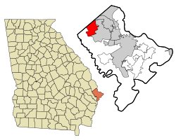
Henderson is an unincorporated community and census-designated place (CDP) in Chatham County, Georgia, United States. The population was 2,178 at the 2020 census. It is part of the Savannah metropolitan statistical area.