Isle of Hope, Georgia

Last updated

Isle of Hope, Georgia
Chatham County Georgia Incorporated and Unincorporated areas Isle of Hope Highlighted.svg
Location in Chatham County and the state of Georgia
Coordinates: 31°59′0″N81°3′20″W / 31.98333°N 81.05556°W / 31.98333; -81.05556
Country United States
State Georgia
County Chatham
Area
[1]
  Total2.28 sq mi (5.91 km2)
  Land1.96 sq mi (5.08 km2)
  Water0.32 sq mi (0.83 km2)
Elevation
[2]
13 ft (4 m)
Population
 (2020)
  Total2,357
  Density1,201.94/sq mi (464.12/km2)
Time zone UTC-5 (Eastern (EST))
  Summer (DST) UTC-4 (EDT)
FIPS code 13-41484 [3]
GNIS feature ID0332069 [2]

Isle of Hope is an unincorporated community and census-designated place (CDP) in Chatham County, Georgia, United States. It is part of the Savannah Metropolitan Statistical Area, and at the 2020 U.S. census its population was 2,357. [4] The island is one of the most affluent communities in the state and is well known for its historic plantations and exclusive waterfront properties.

Contents

History

Isle of Hope is an island surrounded on all sides by water at high tide. Early maps referred to in French as "L'Isle Desperance" (modern French: L'Île d'Espérance). Legends abound of pirates using the island to hide their booty, and generations of children have gone digging for this treasure. Legend also states that French Huguenots used the island as a place of refuge for fleeing persecution.

In 1733, when General James Oglethorpe founded the Georgia colony, a surveyor named Noble Jones was granted a tract on the island that was eventually named Wormsloe, possibly after an English estate but more probably due to the mulberry trees that were grown there, the worms of which, it was hoped, would form the basis for a silk industry. A Colonial-era fortified home made of tabby was built at the Skidaway Narrows (now Jones' Narrows) and today can be visited as part of Wormsloe Historic Site.

Jones, along with James Fallowfield and Henry Parker, settled permanently on the island. During nearby Savannah's frequent yellow fever epidemics, the island was host to Savannahians fleeing the miasma of the city's fevers. As greater numbers of people discovered the island, the former plantation lands were subdivided and the lots sold, and it became a fashionable summer retreat. Several homes from the antebellum period remain, including the 1820 former caretaker's cottage of Carsten Hall plantation. Although the plantation itself burned in the early 20th century, the family moved into the caretaker's cottage overlooking the Intracoastal Waterway.

In the early 20th century, with better transportation options, the summer resort became the year-round home of many, and the terrapin farm at Barbee's Pavilion became world-famous for the export of terrapins for stew, including to the major restaurants of New York City and to the Czar of Russia. It was also the destination of race car drivers from around the world for the International Grand Prix races.

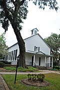
The Isle of Hope United Methodist Church is another historic location on the island. Built before the Civil War, the property was used by the Confederates as an encampment and the church building as a hospital. During their recuperation, soldiers carved their initials into the pews, which they used for makeshift beds. When the old church burned down during its 1984 renovation, the pews had been removed and were saved. Thirty-three Confederate soldiers are buried in the churchyard. In 2000, the church finished construction of transepts to the main sanctuary structure.

The island's beauty and history has attracted a number of Hollywood film productions, including the Oscar-winning Glory , the original Cape Fear , The Last of the Belles , Forrest Gump , and The Last Song .

Geography

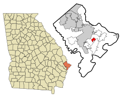
Isle of Hope is located southeast of Savannah at 31°59′0″N81°3′20″W / 31.98333°N 81.05556°W / 31.98333; -81.05556 (31.983380, -81.055686). [5] It consists of the northern half of the physical Isle of Hope, a body of land surrounded by tidal inlets: the Moon River and Herb River to the northwest, Grimball Creek to the northeast, and the Skidaway River and Skidaway Narrows, part of the Intracoastal Waterway, to the southeast. The CDP is bordered by the Dutch Island CDP to the northeast and the Skidaway Island CDP to the southeast. The Isle of Hope CDP includes the communities of Parkersburg and Wymberley.

According to the United States Census Bureau, the CDP has a total area of 2.3 square miles (5.9 km2), of which 1.8 square miles (4.7 km2) is land and 0.46 square miles (1.2 km2), or 20.61%, is water. [4]

Demographics

Historical population
CensusPop.Note
1990 2,637
2000 2,605−1.2%
2010 2,402−7.8%
2020 2,357−1.9%
U.S. Decennial Census [6]
1850-1870 [7] 1870-1880 [8]
1890-1910 [9] 1920-1930 [10]
1940 [11] 1950 [12] 1960 [13]
1970 [14] 1980 [15] 1990 [16]
2000 [17] 2010 [18] 2020 [19]

Isle of Hope first appeared as a census designated place in the 1990 U.S. Census. [16] [17]

Isle of Hope CDP, Georgia – Racial and Ethnic Composition
(NH = Non-Hispanic)
Note: the US Census treats Hispanic/Latino as an ethnic category. This table excludes Latinos from the racial categories and assigns them to a separate category. Hispanics/Latinos may be of any race.
Race / EthnicityPop 2000 [20] Pop 2010 [18] Pop 2020 [19] % 2000% 2010% 2020
White alone (NH)2,5402,2932,20397.50%95.46%93.47%
Black or African American alone (NH)2232190.84%1.33%0.81%
Native American or Alaska Native alone (NH)0100.00%0.04%0.00%
Asian alone (NH)92790.35%1.12%0.38%
Pacific Islander alone (NH)0000.00%0.00%0.00%
Some Other Race alone (NH)1240.04%0.08%0.17%
Mixed Race or Multi-Racial (NH)515430.19%0.62%1.82%
Hispanic or Latino (any race)2832791.07%1.33%3.35%
Total2,6052,4022,357100.00%100.00%100.00%

As of the census [3] of 2000, there were 2,605 people, 1,001 households, and 783 families residing in the CDP. The population density was 1,373.2 inhabitants per square mile (530.2/km2). There were 1,038 housing units at an average density of 547.2 per square mile (211.3/km2). The racial makeup of the CDP was 98.27% White, 0.84% African American, 0.35% Asian, 0.27% from other races, and 0.27% from two or more races. Hispanic or Latino of any race were 1.07% of the population.

There were 1,001 households, out of which 36.0% had children under the age of 18 living with them, 67.6% were married couples living together, 8.1% had a female householder with no husband present, and 21.7% were non-families. 19.8% of all households were made up of individuals, and 10.2% had someone living alone who was 65 years of age or older. The average household size was 2.60 and the average family size was 3.00.

In the CDP, the population was spread out, with 26.6% under the age of 18, 4.2% from 18 to 24, 25.4% from 25 to 44, 26.9% from 45 to 64, and 16.8% who were 65 years of age or older. The median age was 42 years. For every 100 females, there were 92.5 males. For every 100 females age 18 and over, there were 85.5 males.

The median income for a household in the CDP was $75,274, and the median income for a family was $79,586. Males had a median income of $52,175 versus $38,468 for females. The per capita income for the CDP was $34,067. None of the families and 0.2% of the population were living below the poverty line, including no under eighteens and none of those over 64.

Education

Isle of Hope K-8 School Isle of Hope K-8 School.jpg
Isle of Hope K-8 School

It is in the Savannah-Chatham County Public Schools. [21] Schools include:

Notable people

Related Research Articles

<span class="mw-page-title-main">Savannah, Georgia</span> Oldest city in Georgia, United States

Savannah is the oldest city in the U.S. state of Georgia and the county seat of Chatham County. Established in 1733 on the Savannah River, the city of Savannah became the British colonial capital of the Province of Georgia and later the first state capital of Georgia. A strategic port city in the American Revolution and during the American Civil War, Savannah is today an industrial center and an important Atlantic seaport. It is Georgia's fifth most populous city, with a 2020 U.S. census population of 147,780. The Savannah metropolitan area, Georgia's third-largest, had a 2020 population of 404,798.

<span class="mw-page-title-main">Chatham County, Georgia</span> County in Georgia, United States

Chatham County is located in the U.S. state of Georgia, on the state's Atlantic coast. The county seat and largest city is Savannah. One of the original counties of Georgia, Chatham County was created February 5, 1777, and is named after William Pitt, 1st Earl of Chatham.

<span class="mw-page-title-main">Burke County, Georgia</span> County in Georgia, United States

Burke County is a county located along the eastern border of the U.S. state of Georgia in the Piedmont. As of the 2020 census, the population was 24,596. The county seat is Waynesboro. Burke County is part of the Augusta-Richmond County, GA-SC metropolitan statistical area.

Plantation Mobile Home Park is a census-designated place (CDP) in Palm Beach County, Florida, United States. It is part of the Miami metropolitan area of South Florida. The population was 1,462 at the 2020 US census.

<span class="mw-page-title-main">Lakeview, Georgia</span> Place in Georgia, United States

Lakeview is an unincorporated community and census-designated place (CDP) in Catoosa and Walker counties in the U.S. state of Georgia. The population was 4,820 at the 2000 census and 4,777 at the 2020 census. It is part of the Chattanooga, TN–GA Metropolitan Statistical Area.

<span class="mw-page-title-main">Georgetown, Chatham County, Georgia</span> Place in Georgia, United States

Georgetown is an unincorporated community and census-designated place (CDP) in Chatham County, Georgia, United States. The population was 11,916 at the 2020 U.S. census. Georgetown lies across the Little Ogeechee River from Savannah, Georgia, and is a suburban "bedroom community" of Savannah, where most of its adult residents work. It is part of the Savannah Metropolitan Statistical Area.

<span class="mw-page-title-main">Skidaway Island, Georgia</span> Place in Georgia, United States

Skidaway Island is an unincorporated community and census-designated place (CDP) in Chatham County, Georgia, and lies on a barrier island of the same name. Located south of Savannah, Skidaway Island is known for its waterfront properties and golf courses within The Landings, one of the largest gated communities in the country. The population was 9,310 at the 2020 census. For statistical purposes, the United States Census Bureau has defined Skidaway Island as a census-designated place (CDP). A separate area of the island hosts the Skidaway Institute of Oceanography, a research institution operated by the University of Georgia. It receives scholars and researchers from several other Georgia universities as well, including Georgia Tech, Savannah State University, and the College of Coastal Georgia. Skidaway Island is part of the Savannah Metropolitan Statistical Area.

<span class="mw-page-title-main">Whitemarsh Island, Georgia</span> Place in Georgia, United States

Whitemarsh Island is an unincorporated community and census-designated place (CDP) in Chatham County, Georgia, United States. The population was 6,983 at the 2020 U.S census. It is part of the Savannah metropolitan statistical area. The communities of Whitemarsh Island are a relatively affluent suburb of Savannah.

<span class="mw-page-title-main">Wilmington Island, Georgia</span> Place in Georgia, United States

Wilmington Island is an unincorporated community and census-designated place (CDP) in Chatham County, Georgia. The population was 15,129 at the time of the 2020 U.S. census. It is part of the Savannah metropolitan area. The communities of Wilmington Island form a large and affluent suburb of Savannah, where most residents work. The island lies east of Savannah between the town of Thunderbolt and the beach community of Tybee Island.

<span class="mw-page-title-main">Evans, Georgia</span> Place in Georgia, United States

Evans is an unincorporated community and census-designated place (CDP) in Columbia County, Georgia, United States. It is a suburb of Augusta and is part of the Augusta metropolitan area. The population was 29,011 at the 2010 census, up from 17,727 at the 2000 census.

<span class="mw-page-title-main">Martinez, Georgia</span> Place in Georgia, United States

Martinez is an unincorporated community and census-designated place (CDP) in Columbia County, Georgia, United States. It is a northwestern suburb of Augusta and is part of the Augusta, Georgia metropolitan area. The population was 34,535 at the 2020 census.

<span class="mw-page-title-main">Gumlog, Georgia</span> Place in Georgia, United States

Gumlog is an unincorporated lakeside community and census-designated place in Franklin County, Georgia, United States. The population was 2,146 at the 2010 census.

<span class="mw-page-title-main">St. Simons, Georgia</span> Place in Georgia, United States

St. Simons Island is a barrier island and census-designated place (CDP) located on St. Simons Island in Glynn County, Georgia, United States. The names of the community and the island are interchangeable, known simply as "St. Simons Island" or "SSI", or locally as "The Island". St. Simons is part of the Brunswick metropolitan statistical area, and according to the 2020 U.S. census, the CDP had a population of 14,982. Located on the southeast Georgia coast, midway between Savannah and Jacksonville, St. Simons Island is both a seaside resort and residential community. It is the largest of Georgia's renowned Golden Isles. Visitors are drawn to the Island for its warm climate, beaches, variety of outdoor activities, shops and restaurants, historical sites, and natural environment.

Wallace is a census-designated place (CDP) in St. John the Baptist Parish, Louisiana, United States. The population was 570 at the 2000 census. It is part of the New Orleans–Metairie–Kenner Metropolitan Statistical Area. The rural community is on the west bank of the Mississippi River and easily accessible to Interstate 10 via the Gramercy Bridge.

<span class="mw-page-title-main">Mitchellville, Maryland</span> Census-designated place in Maryland

Mitchellville is an upper-class majority African-American unincorporated area and census-designated place (CDP) in Prince George's County, Maryland, United States. Per the 2020 census, the population was 11,136.

<span class="mw-page-title-main">Gordon Heights, New York</span> Hamlet and census-designated place in New York, United States

Gordon Heights is a hamlet and census-designated place (CDP) in the Town of Brookhaven, Suffolk County, Long Island, New York, United States. The population was 3,981 at the 2020 census.

<span class="mw-page-title-main">Roebuck, South Carolina</span> CDP in South Carolina, United States

Roebuck is a census-designated place (CDP) in Spartanburg County, South Carolina, United States. The population was 2,200 at the 2010 census.

Beech Island is an unincorporated community and census-designated place (CDP) in Aiken County, South Carolina, United States. It was first listed as a CDP in the 2020 census with a population of 1,421.

<span class="mw-page-title-main">Wormsloe Historic Site</span> United States historic place

The Wormsloe Historic Site, originally known as Wormsloe Plantation, is a state historic site near Savannah, Georgia, in the southeastern United States. The site consists of 822 acres (3.33 km2) protecting part of what was once the Wormsloe Plantation, a large estate established by one of Georgia's colonial founders, Noble Jones. The site includes a picturesque 1.5 miles (2.4 km) oak avenue, the ruins of Jones' fortified house built of tabby, a museum, and a demonstration area interpreting colonial daily life.

Dutch Island is an unincorporated community and census-designated place (CDP) in Chatham County, Georgia, United States. It is part of the Savannah Metropolitan Statistical Area, and at the 2020 census, its population was 1,238.

References

  1. "2020 U.S. Gazetteer Files". United States Census Bureau. Retrieved December 18, 2021.
  2. 1 2 U.S. Geological Survey Geographic Names Information System: Isle of Hope, Georgia
  3. 1 2 "U.S. Census website". United States Census Bureau . Retrieved January 31, 2008.
  4. 1 2 "Geographic Identifiers: 2010 Demographic Profile Data (G001): Isle of Hope CDP, Georgia". U.S. Census Bureau, American Factfinder. Archived from the original on February 12, 2020. Retrieved July 22, 2014.
  5. "US Gazetteer files: 2010, 2000, and 1990". United States Census Bureau. February 12, 2011. Retrieved April 23, 2011.
  6. "Decennial Census of Population and Housing by Decade". United States Census Bureau.
  7. "1870 Census of Population - Georgia - Population of Civil Divisions less than Counties" (PDF). United States Census Bureau. 1870.
  8. "1880 Census of Population - Georgia - Population of Civil Divisions less than Counties" (PDF). United States Census Bureau. 1880.
  9. "1910 Census of Population - Georgia" (PDF). United States Census Bureau. 1930.
  10. "1930 Census of Population - Georgia" (PDF). United States Census Bureau. 1930. pp. 251–256.
  11. "1940 Census of Population - Georgia" (PDF). United States Census Bureau. 1940.
  12. "1950 Census of Population - Georgia" (PDF). United States Census Bureau. 1980.
  13. "1960 Census of Population - Population of County Subdivisions - Georgia" (PDF). United States Census Bureau. 1960.
  14. "1970 Census of Population - Population of County Subdivisions - Georgia" (PDF). United States Census Bureau. 1970.
  15. "1980 Census of Population - Number of Inhabitants - Georgia" (PDF). United States Census Bureau. 1980.
  16. 1 2 "1990 Census of Population - Summary Social, Economic, and Housing Characteristics - Georgia" (PDF). United States Census Bureau. 1990.
  17. 1 2 "2000 Census of Population - General Population Characteristics - Georgia" (PDF). United States Census Bureau. 2000.
  18. 1 2 "P2 Hispanic or Latino, and Not Hispanic or Latino by Race – 2010: DEC Redistricting Data (PL 94-171) - Isle of Hope CDP, Georgia". United States Census Bureau .
  19. 1 2 "P2 Hispanic or Latino, and Not Hispanic or Latino by Race – 2020: DEC Redistricting Data (PL 94-171) - Isle of Hope CDP, Georgia". United States Census Bureau .
  20. "P004 Hispanic or Latino, and Not Hispanic or Latino by Race – 2000: DEC Summary File 1 – Isle of Hope CDP, Georgia". United States Census Bureau .
  21. "2020 CENSUS - SCHOOL DISTRICT REFERENCE MAP: Chatham County, GA" (PDF). U.S. Census Bureau . Retrieved March 19, 2023. - Text list
  22. "Home". Isle of Hope K-8 School. Retrieved March 19, 2023. 100 Parkersburg Road Savannah, Georgia 31406 - Despite having a Savannah postal address, it is in the Isle of Hope CDP.