Blue Mountain (Washington)

Last updated
Blue Mountain
West aspect of Blue Mountain at sunset.jpg
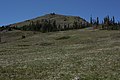
West aspect, viewed from Hurricane Ridge Road
Highest point
Elevation 6,004 ft (1,830 m) [1]
Prominence 1,107 ft (337 m) [2]
Parent peak Maiden Peak (6,434 ft) [2]
Isolation 3.14 mi (5.05 km) [2]
Coordinates 47°57′16″N123°15′34″W / 47.9545206°N 123.2594388°W / 47.9545206; -123.2594388 Coordinates: 47°57′16″N123°15′34″W / 47.9545206°N 123.2594388°W / 47.9545206; -123.2594388 [1]
Geography
USA Washington relief location map.jpg
Red triangle with thick white border.svg
Blue Mountain
Location of Blue Mountain in Washington
Usa edcp relief location map.png
Red triangle with thick white border.svg
Blue Mountain
Blue Mountain (the United States)
Location Olympic National Park
Clallam County, Washington, US
Parent range Olympic Mountains
Topo map USGS Maiden Peak
Geology
Age of rock Eocene
Climbing
Easiest route class 1 walking

Blue Mountain is a 6,004-foot-elevation (1,830 meter) mountain summit located within Olympic National Park in Clallam County of Washington state. Blue Mountain is situated in the Daniel J. Evans Wilderness, 13 miles southeast of Port Angeles and 11 miles southwest of Sequim. Topographic relief is significant as the south aspect rises 4,000 feet (1,220 meters) above Gray Wolf River in approximately 2.5 miles. The mountain's name is due to a soft, blue haze that forms around the mountain in the summer. [3] New settlers to the Olympic Peninsula near the end of the 19th century brought devastating fires started by land clearing and logging activities. [4] The Dungeness Fire of 1891 burned about 30,000 acres, destroying much of the forest around Blue Mountain. [3]

Contents

Access is via the 19-mile Deer Park Road, and the summit can be reached by walking the half-mile Rain Shadow Loop Trail which gains 170 feet of elevation from road's end. [5] The trail is so named because Blue Mountain lies within the rain shadow of the Olympic Mountains, receiving 50 inches of precipitation annually compared to more than 200 inches on Mount Olympus, 23 miles distant. [6] Precipitation runoff from the mountain drains north to the Strait of Juan de Fuca via Maiden Creek, Siebert Creek, McDonald Creek, Canyon Creek, and Gray Wolf River. The summit offers a view of the San Juan Islands, Victoria across the strait on Vancouver Island, Canada, and on a clear day the eye can see as far as Mount Baker, 87 miles away. The endemic Olympic bellflower can be found near the summit. [5]

Climate

Based on the Köppen climate classification, Blue Mountain is located in the marine west coast climate zone of western North America. [7] Most weather fronts originate in the Pacific Ocean, and travel east toward the Olympic Mountains. As fronts approach, they are forced upward by the peaks of the Olympic Range, causing them to drop their moisture in the form of rain or snowfall (Orographic lift). As a result, the Olympics experience high precipitation, especially during the winter months. During winter months, weather is usually cloudy, but due to high pressure systems over the Pacific Ocean that intensify during summer months, there is often little or no cloud cover during the summer.

Geology

The Olympic Mountains are composed of obducted clastic wedge material and oceanic crust, primarily Eocene sandstone, turbidite, and basaltic oceanic crust. [8] The mountains were sculpted during the Pleistocene era by erosion and glaciers advancing and retreating multiple times.

See also

Related Research Articles

Mount Constance

Mount Constance is a peak in the Olympic Mountains of Washington and the third highest in the range. It is the most visually prominent peak on Seattle's western skyline. Despite being almost as tall as the ice-clad Mount Olympus to the west, Mount Constance has little in the way of glaciers and permanent snow because the eastern, and particularly this northeastern, portion of the Olympics receives far less precipitation. However the narrow and steep Crystal Glacier still exists on the mountain's north face, shaded by the bulk of the main peak and with a small lake at its terminus. In addition, the treeline is higher here than mountains to the west, also hinting at the drier alpine conditions.

Mount Deception (Washington)

Mount Deception is a peak in the Olympic Mountains of Cascadia. It is in Olympic National Park on the Olympic Peninsula in the U.S. state of Washington.

Mount Angeles

Mount Angeles is located just south of Port Angeles, Washington in the Olympic National Park. It is the highest peak in the Hurricane Ridge area. The summit, which offers panoramic views of the Strait of Juan de Fuca and many of the peaks of the interior Olympic Mountains can be climbed from the Klahane Ridge trail.

Mount Mystery

Mount Mystery is a prominent 7,639-foot (2,328-metre) mountain summit located in the Olympic Mountains in Jefferson County of Washington state. It is located within Olympic National Park on the Olympic Peninsula. Mount Mystery is the sixth-highest peak of the Olympic Mountains, after Mount Olympus, Mount Deception, Mount Constance, Mount Johnson, and Inner Constance. Its nearest higher neighbor is Mount Deception, 1.32 mi (2.12 km) to the north-northwest. Little Mystery (6941 ft) is a subsidiary summit south of Mount Mystery.

Rocky Peak (Washington)

Rocky Peak is a 6,218 feet (1,895 m) summit in the Olympic Mountains and is located in Clallam County of Washington state. It is situated eight miles south of Port Angeles, Washington within Olympic National Park. Its nearest higher peak is Mount Angeles, 1.87 mi (3.01 km) to the west. Klahhane Ridge connects these two peaks. Travelers on the scenic Hurricane Ridge Road traverse the lower south slope of Rocky Peak en route to the Hurricane Ridge visitor center. The mountain was named Rocky Peak by local people from the time of the earliest settlers in the area. Precipitation runoff from the north side of the peak drains into Rocky Creek, whereas the south slope drains into Morse Creek, thence into the Strait of Juan de Fuca.

Warrior Peak

Warrior Peak is a 7,320+ ft double summit mountain located in Olympic National Park in Jefferson County of Washington state. Warrior is the 11th highest peak in the Olympic Mountains Range. The southeast summit is the slightly higher of the two summits, the northwest peak is estimated at 7285 feet elevation. Warrior Peak is easy to identify from Seattle, since it appears as the first prominent peak immediately north of Mount Constance, which is the dominant peak on the skyline. Warrior's nearest higher peak is in fact Mount Constance, 0.8 mi (1.3 km) to the south-southeast. The first ascent of the mountain was made in 1945 by Fred Beckey, who solo climbed both summits, and named the mountain.

Sentinel Peak (Jefferson County, Washington)

Sentinel Peak is a 6,592-foot-high (2,009 m) mountain summit located in the Olympic Mountains, in Jefferson County of Washington state. Rising in the center of Olympic National Park, its nearest higher neighbor is Mount Fromme, 1.42 miles (2.29 km) to the northwest. Sentinels Sister is a lower 6,301-foot-high (1,921 m) companion summit situated 0.65 miles (1.05 km) to the southwest. The two peaks stand as sentinels above the Dosewalips Valley and Hayden Pass, and were possibly named by an early expedition of the Seattle Mountaineers. Precipitation runoff from the peak drains to Hood Canal via the Dosewallips River.

Elk Mountain (Clallam County, Washington)

Elk Mountain is a 6,773 feet (2,064 m) summit located in the Olympic Mountains, in Clallam County of Washington state. It is set within Olympic National Park and is situated at the eastern end of Hurricane Ridge. Its nearest higher peak is McCartney Peak, 5.12 mi (8.24 km) to the south-southwest. Precipitation runoff from the south slope of the mountain drains into tributaries of the Dungeness River, whereas the north slope is drained by tributaries of Morse Creek which thence empties into the Strait of Juan de Fuca.

Mount Fitzhenry

Mount Fitzhenry is a 6,050-foot (1,840-metre) mountain summit located within Olympic National Park in Clallam County of Washington state. Mt. Fitzhenry is in the Bailey Range which is a subrange of the Olympic Mountains. In clear weather, the mountain can be seen from the visitor center at Hurricane Ridge. Its nearest higher neighbor is Mount Fairchild, 1.57 mi (2.53 km) to the south. Precipitation runoff from the mountain drains into tributaries of the Elwha River. Mount Fitzhenry is situated at the head of Fitzhenry Creek, and both are named for Edward Allen Fitzhenry (1868–1937), Clallam County surveyor from 1892-1900. President Woodrow Wilson appointed Fitzhenry as Washington Surveyor General in 1913, and he later served as Deputy State Land Commissioner.

Mount Fairchild

Mount Fairchild, also known as Mount William Fairchild, is a 6,900-foot (2,100-metre) glaciated mountain summit located within Olympic National Park in Clallam County of Washington state. Mt. Fairchild is the second-highest peak in the Bailey Range which is a subrange of the Olympic Mountains. Its nearest higher neighbor is Mount Carrie, 0.84 mi (1.35 km) to the southwest, and Ruth Peak is set 0.92 mi (1.48 km) to the south. In clear weather, the mountain can be seen from the visitor center at Hurricane Ridge. Precipitation runoff from the mountain drains into tributaries of the Elwha River.

Martin Peak (Olympic Mountains)

Martin Peak is a mountain summit in the Olympic Mountains and is located in Jefferson County of Washington state. It is located within Olympic National Park. At 7,638 feet (2,328 m) high, Martin Peak is the seventh-highest peak of the Olympic Mountains, and the second-highest peak in The Needles range, which is a subset of the Olympic range. Its nearest higher neighbor is Mount Johnson, 0.53 mi (0.85 km) to the north-northwest. Precipitation runoff from this peak drains west into headwaters of Gray Wolf River, or east into Royal Creek, both of which are part of the Dungeness River drainage basin. Martin Peak was given its name based on the first ascent in 1940 by George W. Martin (1901–1970), and Elvin Johnson.

Sundial (Olympic Mountains)

Sundial is a 7,200+ ft mountain summit located within Olympic National Park, in Jefferson County of Washington state. Sundial is part of The Needles range, which is a subrange of the Olympic Mountains. Its nearest higher neighbor is Mount Clark, 0.27 mi (0.43 km) to the northwest, and Mount Johnson is set 0.45 mi (0.72 km) to the west. The climbing routes on Sundial start at class 3 scrambling via the East Face, and range up to class 5 via the South Side Face. The first ascent of the mountain was made in 1944 by Adel and William Degenhardt. The mountain is so named because the time of day can be approximated as an observer in Royal Basin watches the sun's rays make their way down the east face of this mountain in the morning. Precipitation runoff from the mountain drains into Royal Creek which is a tributary of the Dungeness River.

Mount Mathias

Mount Mathias is a 7,156-foot (2,181-metre) mountain summit located within Olympic National Park in Jefferson County of Washington state. Its nearest higher neighbor is Mount Olympus, 1.76 mi (2.83 km) to the east. Mount Mathias is wedged between the massive Blue Glacier below its west slope, and the Hoh Glacier on the east side. Precipitation runoff from the mountain drains into the Hoh River.

Aries (mountain)

Aries is a 6,533-foot (1,991-metre) mountain summit located within Olympic National Park in Jefferson County of Washington state. Its neighbors include Mount Olympus, 2.46 mi (3.96 km) to the west, Athena 1.7 mi (2.7 km) to the southwest, and Mount Mathias 1.11 mi (1.79 km) to the northwest. Aries is wedged between the Hoh Glacier and the Humes Glacier, and immediately northeast of Blizzard Pass. Precipitation runoff from the mountain drains into headwaters of the Queets and Hoh Rivers. This mountain was named by glaciologists Richard Hubley and Edward LaChapelle in 1955, in preparation for the International Geophysical Year. It is named for Aries in keeping with the Greek and Roman mythology naming theme surrounding Mount Olympus.

Muncaster Mountain

Muncaster Mountain is a 5,910-foot (1,800-metre) mountain summit located within Olympic National Park in Jefferson County of Washington state. It is situated 4.4 mi (7.1 km) south-southeast of Mount Christie, and 14.6 mi (23.5 km) southeast of Mount Olympus. Precipitation runoff from the mountain drains into Rustler Creek, which is a tributary of the Quinault River. Although modest in elevation, relief is significant as the summit rises 4,000 feet above the Rustler Creek valley in one mile.

Mount Lena (Washington)

Mount Lena is a 5,995-foot-elevation mountain summit located in the Olympic Mountains, in Jefferson County of Washington state. It is situated within Olympic National Park, immediately north and 1,500 feet above the shore of Upper Lena Lake. Mt. Lena has a subsidiary peak, East Peak (5800+ ft/1768+ m), which lies northeast of the lake. Mount Bretherton lies across the lake to the south, Mount Stone is three miles to the southwest, and The Brothers approximately 3.5 miles to the northeast. Precipitation runoff from the mountain drains north to the Duckabush River, and south into the Hamma Hamma River via Lena Creek. The non-technical ascent of Mount Lena involves hiking eight miles (one-way) and 5,300 feet elevation gain via the Upper Lena Lake Trail and cross-country above the lake, with most favorable conditions from July through September. There are pleasant campsites at the lake, and the ascent to the summit takes 1.5 hour from the lake. This mountain's name has been officially adopted by the United States Board on Geographic Names.

Chimney Peak (Olympic Mountains)

Chimney Peak is a 6,917-foot-elevation (2,108 meter) mountain summit located within Olympic National Park in Jefferson County of Washington state. Chimney Peak is situated near the head of Elwha Valley, and immediately north above Enchanted Valley. Topographic relief is significant as the southeast aspect rises 4,800 feet (1,463 meters) above Enchanted Valley in less than one mile. Enchanted Valley is also known as Valley of 10,000 Waterfalls, and numerous waterfalls tumble down the immense cliffs of Chimney Peak. Neighbors include Crystal Peak, 2.2 mi (3.5 km) to the north, White Mountain 3.5 mi (5.6 km) to the east, and West Peak 3.4 mi (5.5 km) to the northeast. Precipitation runoff from the mountain drains north to the Elwha River, and south to the Quinault River.

Crystal Peak (Olympic Mountains)

Crystal Peak is a 6,896-foot-elevation (2,102 meter) mountain summit located within Olympic National Park in Jefferson County of Washington state. Crystal Peak is situated two miles north of Enchanted Valley, near the heads of Hayes River and Quinault River. Topographic relief is significant as the northeast aspect rises 3,300 feet (1,006 meters) above Hayes River in less than one mile. Precipitation runoff from the mountain drains north to the Elwha River via Hayes River and Godkin Creek. Neighbors include line parent Chimney Peak, 2.2 mi (3.5 km) to the south, and proximate parent West Peak, 2.0 mi (3.2 km) to the east. The lower slopes of the mountain are surrounded by Western Red Cedar, Sitka Spruce, Western Hemlock, Alaskan Cedar, Mountain Hemlock, and Douglas-fir of the Quinault Rainforest.

Mount Cameron (Washington)

Mount Cameron is a 7,190-foot-elevation (2,192 meter) triple-summit mountain located within Olympic National Park in Jefferson County of Washington state. Mount Cameron is situated 21 miles southwest of Sequim, and set within the Daniel J. Evans Wilderness. Topographic relief is significant as the southeast aspect rises over 3,300 feet (1,006 meters) above the Dosewallips River in approximately one mile. Precipitation runoff from the mountain drains south into the Dosewallips River, north to the Gray Wolf River via Cameron Creek, and west into headwaters of Lost River. Neighbors include line parent Mount Deception, 4.5 mi (7.2 km) to the east, and proximate parent Mount Johnson, 4.5 mi (7.2 km) to the east.

Unicorn Peak (Olympic Mountains)

Unicorn Peak is a 5,100-foot-elevation (1,554 meter) mountain summit located within Olympic National Park in Clallam County of Washington state. Unicorn Peak is situated seven miles southwest of Port Angeles and three miles north-northwest of the park's Hurricane Ridge visitor center, in Daniel J. Evans Wilderness. Precipitation runoff from the mountain drains west to the Elwha River via Little River and Griff Creek. Topographic relief is significant as the west aspect rises 4,800 feet (1,463 meters) above the Elwha valley in approximately three miles.

References

  1. 1 2 "Blue Mountain". Geographic Names Information System . United States Geological Survey . Retrieved 2021-12-29.
  2. 1 2 3 "Blue Mountain - 6,007' WA". listsofjohn.com. Retrieved 2021-12-29.
  3. 1 2 Parratt, Smitty (1984). Gods and Goblins: A Field Guide to Place Names of Olympic National Park (1st ed.).
  4. "Fire History - Olympic National Park (U.S. National Park Service)". nps.gov. Retrieved 2021-12-30.
  5. 1 2 "Deer Park Area Brochure - Olympic National Park (U.S. National Park Service)". nps.gov. Retrieved 2021-12-30.
  6. Alan Leftridge, 2017, The Best of Olympic National Park, Farcountry Press, ISBN   9781560376620
  7. Peel, M. C.; Finlayson, B. L.; McMahon, T. A. (2007). "Updated world map of the Köppen−Geiger climate classification". Hydrol. Earth Syst. Sci. 11: 1633–1644. ISSN   1027-5606.
  8. Alt, D.D.; Hyndman, D.W. (1984). Roadside Geology of Washington. pp. 249–259. ISBN   0-87842-160-2.

Commons-logo.svg Media related to Blue Mountain (Washington) at Wikimedia Commons