Bluff Dale, Texas

Last updated

Bluff Dale, Texas
Bluff Dale (1 of 1).jpg
USA Texas location map.svg
Red pog.svg
Bluff Dale
Coordinates: 32°20′59″N98°01′18″W / 32.34972°N 98.02167°W / 32.34972; -98.02167
Country United States
State Texas
County Erath
Population
 (2020)
  Total151
Time zone UTC−06:00 (CST)
  Summer (DST) UTC−05:00 (CDT)
Area code 254

Bluff Dale is an unincorporated community and census designated place (CDP) in Erath County, Texas, United States.

Contents

The Bluff Dale Independent School District serves area students.

Bluff Dale, Texas is on U.S. Highway 377 and the North Paluxy River in northeastern Erath County. It was originally called Bluff Springs by pioneers who settled nearby; Bluff Dale became the town name when the post office was established in 1877. In 1889, when the Fort Worth and Rio Grande Railway was built, Jack Glenn donated land for the development of a town. The town was incorporated in 1908. By 1915, a bank and newspaper had been developed. In 1936, Bluff Dale had 680 residents, 500 in 1940, 123 in 1980, and 300 in 1989. In 1989, the town had a Garden Club, three churches, a volunteer fire department, five historical markers, and a beautification committee. A gas station–convenience store was built circa 2002. Around 2005, a bank was opened up. [1]

Demographics

Historical population
CensusPop.Note
2020 151
U.S. Decennial Census [2]
1850–1900 [3] 1910 [4]
1920 [5] 1930 [6] 1940 [7]
1950 [8] 1960 [9] 1970 [10]
1980 [11] 1990 [12] 2000 [13]
2010 [14] 2020 [15]

Bluff Dale first appeared as a census designated place in the 2020 U.S. Census. [16] [15]

2020 Census

Bluff Dale CDP, Texas – Racial and ethnic composition
Note: the US Census treats Hispanic/Latino as an ethnic category. This table excludes Latinos from the racial categories and assigns them to a separate category. Hispanics/Latinos may be of any race.
Race / Ethnicity (NH = Non-Hispanic)Pop 2020 [15] % 2020
White alone (NH)13790.73%
Black or African American alone (NH)00.00%
Native American or Alaska Native alone (NH)10.66%
Asian alone (NH)00.00%
Pacific Islander alone (NH)00.00%
Other race alone (NH)10.66%
Mixed race or Multiracial (NH)74.64%
Hispanic or Latino (any race)53.31%
Total151100.00%

Housing

The median home cost in Bluff Dale is $208,600. Home appreciation the last year has been -0.36 percent.

Cost of living

Compared to the rest of the country, Bluff Dale's cost of living is 16.43% lower than average.

Education

Bluff Dale public schools spend $6,770 per student. The average school expenditure in the U.S. is $6,058. There are about 11 students per teacher in Bluff Dale (zip 76433).

Unemployment

The unemployment rate in Bluff Dale is 3.20 percent (U.S. average is 4.60 percent). Recent job growth is positive. Bluff Dale jobs have increased by 1.82 percent.

http://www.bestplaces.net/zip-code/Bluff_Dale_TX-77643300000.aspx

Historical markers

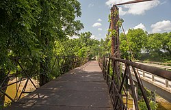
Bluff Dale Suspension Bridge

This iron bridge was open to the public spanning the Paluxy River in 1891.

Berry Creek Rd. (CR-149), ¼ mile N. of US-377, Bluff Dale, Erath County Texas

While the historical marker identifies the bridge as a suspension bridge, it is actually a cable stayed bridge design, and as such is probably the oldest of its type in the United States.

http://www.historicmarkers.com/Texas/Erath_County_Texas/Bluff_Dale_Suspension_Bridge__TX441/

Bluff Dale Tabernacle

Built in 1906; the land was donated by Andrew Glenn. Community events, funerals, and school graduations are held here. Originally used for early denominations in revivals that lasted for days.

Recorded Texas Historic Landmark, Texas Historical Commission, 1982.

Glenn St. and Holmes St., Bluff Dale, Erath County Texas

Old Public Water Well TX3786

Dug around 1887 and used in the early days for travelers and cattle herds. The well was dug by the Fort Worth Rio Grande Railroad and was primarily utilized to supply locomotives. Still in use today.

State Historical Survey Committee, 1971.

Greenwood St., Bluff Dale, Erath County Texas

Climate

The climate in this area is characterized by relatively high temperatures and evenly distributed precipitation throughout the year. The Köppen Climate System describes the weather as humid subtropical, and uses the abbreviation Cfa. [17]

Related Research Articles

<span class="mw-page-title-main">Hood County, Texas</span> County in Texas, United States

Hood County is a county in the U.S. state of Texas. As of the 2020 census, the population was 61,598. Its county seat is Granbury. The county is named for John Bell Hood, a Confederate lieutenant general and the commander of Hood's Texas Brigade.

<span class="mw-page-title-main">Tornillo, Texas</span> Place in Texas, United States

Tornillo is a border town in El Paso County, Texas, United States. The population was 1,568 at the 2010 census. For statistical purposes, the United States Census Bureau has defined this unincorporated community as a census-designated place (CDP). It is part of the El Paso Metropolitan Statistical Area. The Tornillo and Guadalupe, Chihuahua, area is connected by the Tornillo–Guadalupe International Bridge.

<span class="mw-page-title-main">Crosby, Texas</span> Census-designated place in Texas, United States

Crosby is a census-designated place in Harris County, Texas, United States. The population was 3,417 at the 2020 census.

<span class="mw-page-title-main">Hartley, Texas</span> CDP in Texas, United States

Hartley is a census-designated place (CDP) in Hartley County, Texas, United States. The population was 540 at the 2010 census.

<span class="mw-page-title-main">Deweyville, Texas</span> CDP in Texas, United States

Deweyville is a census-designated place (CDP) in Newton County, on the central eastern border of Texas, United States. The population was 571 at the 2020 census, down from 1,023 at the 2010 census.

<span class="mw-page-title-main">Redford, Texas</span> CDP in Texas, United States

Redford is a census-designated place (CDP) in Presidio County, Texas, United States. The population was 43 at the 2020 census.

<span class="mw-page-title-main">Tilden, Texas</span> County seat and Census-designated place in Texas, United States

Tilden is an unincorporated community, census-designated place (CDP), and the county seat of McMullen County, Texas, United States. The population was 190 at the 2020 census.

Garden City is a census-designated place (CDP) in and county seat of Glasscock County, Texas, United States. It lies near the center of the county, 27 miles (43 km) south of Big Spring. and at the 2020 census had a population of 334. The ZIP code is 79739.

<span class="mw-page-title-main">Gail, Texas</span> Census-designated place in Borden County, Texas, United States

Gail is a census-designated place in and the county seat of Borden County, Texas, United States, that is ocated at the junction of U.S. Route 180 and Farm to Market Road 669. As of the 2010 Census, the population was 231.

<span class="mw-page-title-main">Bushland, Texas</span> Census-deignated place in Potter County, Texas, United States

Bushland is a census-designated place (CDP) in southwestern Potter and Randall counties in Texas, United States. A small portion of the CDP extends south into Randall County. According to the Handbook of Texas, the community had an estimated population of 130 in 2000. The community is part of the Amarillo, Texas Metropolitan Statistical Area.

<span class="mw-page-title-main">Huckabay, Texas</span> Census-designated place in Erath County, Texas, United States

Huckabay is a census designated place (CDP) in Erath County, Texas, United States, at the intersection of Texas State Highway 108 and Farm to Market Road 219, 10 miles (16 km) northwest of Stephenville. It had a population of approximately 150 in 2000.

<span class="mw-page-title-main">Lingleville, Texas</span> Census-designated place in Erath County, Texas, United States

Lingleville is an census-designated place (CDP) in Erath County, Texas, United States. Lingleville is located at the intersection of Farm to Market Road 8 and Farm to Market Road 219,P{[convert|10|mi|km}} west of Stephenville.

<span class="mw-page-title-main">Bluff Dale Suspension Bridge</span> Bridge in Bluff Dale, Texas

The Bluff Dale Bridge is a historic cable-stayed bridge located near Bluff Dale, Texas, United States. Built in 1891, the bridge spans 225 feet (69 m) across the Paluxy River. The road deck is 28 feet (8.5 m) above the river and held in place by fourteen 1-inch-diameter (2.5 cm) cables attached to the towers made of 9-inch-diameter (23 cm) iron pipe.

<span class="mw-page-title-main">Rosanky, Texas</span> Census-designated place in Bastrop County, Texas, United States

Rosanky is a census designated place (CDP) located on Farm to Market Road 535 in southern Bastrop County, Texas, United States. Rosanky has a post office, with the ZIP code 78953. The town is named for Ed Rosanky, who emigrated from Prussia and settled in the area in 1854.

Proctor is an unincorporated community and census-designated place (CDP) in Comanche County, Texas, United States. According to the Handbook of Texas, the community had an estimated population of 220 in 2000.

Garwood is an unincorporated community and census designated place (CDP) in Colorado County, Texas, United States. According to the Handbook of Texas, the community had a population of 975 in 2000.

<span class="mw-page-title-main">Study Butte, Texas</span> Census-designated place in Texas, United States

Study Butte is a census-designated place (CDP) in Brewster County, Texas, United States. The population was 200 at the 2020 census, down from 233 at the 2010 census. At the 2000 census, the area was part of the Study Butte-Terlingua CDP.

Loma Vista is a census-designated place (CDP) in Starr County, Texas, United States. It is a new CDP, formed from part of the North Escobares CDP prior to the 2010 census, with a population of 160.

Fronton Ranchettes is a census-designated place (CDP) in Starr County, Texas, United States. It is a new CDP, formed from part of the Roma Creek CDP prior to the 2010 census, with a population of 113.

Zarate is a census-designated place (CDP) in Starr County, Texas, United States. This was a new CDP for the 2010 census, with a population of 59.

References

  1. "TSHA | Bluff Dale, TX".
  2. "Decennial Census by Decade". United States Census Bureau .
  3. "1900 Census of Population - Population of Texas By Counties And Minor Civil Divisions" (PDF). United States Census Bureau .
  4. "1910 Census of Population - Supplement for Texas" (PDF). United States Census Bureau .
  5. "1920 Census of Population - Number of Inhabitants - Texas" (PDF). United States Census Bureau .
  6. "1930 Census of Population - Number of Inhabitants - Texas" (PDF). United States Census Bureau .
  7. "1940 Census of Population - Number of Inhabitants - Texas" (PDF). United States Census Bureau .
  8. "1950 Census of Population - Number of Inhabitants - Texas" (PDF). United States Census Bureau .
  9. "1960 Census of Population - Number of Inhabitants - Texas" (PDF). United States Census Bureau .
  10. "1970 Census of Population - Number of Inhabitants - Texas" (PDF). United States Census Bureau .
  11. "1980 Census of Population - Number of Inhabitants - Texas" (PDF). United States Census Bureau .
  12. "1990 Census of Population - Population and Housing Unit Counts - Texas" (PDF). United States Census Bureau .
  13. "2000 Census of Population - Population and Housing Unit Counts - Texas" (PDF). United States Census Bureau .
  14. "2010 Census of Population - Population and Housing Unit Counts - Texas" (PDF). United States Census Bureau .
  15. 1 2 3 "P2: Hispanic or Latino, and Not Hispanic or Latino by Race – 2020: DEC Redistricting Data (PL 94-171) – Bluff Dale CDP, Texas". United States Census Bureau.
  16. "2020 Geography Changes". United States Census Bureau.
  17. Climate Summary for Bluffdale, Texas