
Bodrigan is a settlement in the civil parish of St Tudy in Cornwall. The settlement is first recorded in 1284 and nowadays consists of a farm, cottage and other buildings, three of which have been converted into residences. [1]
Bodrigan is a settlement in the civil parish of St Tudy in Cornwall. The settlement is first recorded in 1284 and nowadays consists of a farm, cottage and other buildings, three of which have been converted into residences. [1]
Restormel was a borough of Cornwall, England, one of the six administrative divisions that made up the county. Its council was based in St Austell; its other towns included Newquay.
Carn Brea is a civil parish and hilltop site in Cornwall, England, United Kingdom. The population of Carn Brea including Bosleake and Church Coombe was 8,013 at the 2011 census. The hilltop site is situated approximately one mile (1.6 km) southwest of Redruth. The settlements of Bosleake, Brea, Broad Lane, Carn Arthen, Carn Brea Village, Carnkie, Four Lanes, Grillis, Illogan Highway, Pencoys, Penhallick, Piece, Pool, Tolskithy, Tregajorran, Treskillard, Tuckingmill and West Tolgus are in the parish.

St Columb Road is a small village near Fraddon and Indian Queens in Cornwall, England, United Kingdom. It lies half a mile (750m) from the A30 road. St Columb Road railway station is on the branch line from Par to Newquay. When it opened in 1876 the station was called Halloon. It was renamed soon afterwards to reflect the existence of St Columb Major further north, and the new name was adopted for the local settlement which followed.

The Helford River is a ria in Cornwall, England, fed by small streams into its many creeks. There are seven creeks on the Helford; from west to east these are Ponsontuel Creek, Mawgan Creek, Polpenwith Creek, Polwheveral Creek, Frenchman's Creek, Port Navas Creek, and Gillan Creek. The best known of these is Frenchman's Creek, made famous by Daphne du Maurier in her novel of the same name. A little further up river is Tremayne Quay, built for a visit by Queen Victoria in the 1840s which she then declined to make, allegedly because it was raining.

Talskiddy is a small rural village about two miles north of St Columb Major in Cornwall, England, United Kingdom. Originally a manorial settlement belonging to the Earldom of Cornwall, the place prospered in the 19th century as a centre of the wool-combing industry.

Bude–Stratton is a civil parish in Cornwall, England, United Kingdom. The largest settlement in the parish is the seaside town of Bude. The parish also includes the market town of Stratton and the settlements of Flexbury, Poughill, Bush, Maer and Northcott north of Bude, and Upton, Lynstone, Thorne and Hele south of Bude.

Ruan Lanihorne is a civil parish and village in south Cornwall, England, United Kingdom. The village is situated approximately four miles (6.5 km) east-southeast of Truro between the River Fal and its tributary the Ruan River.

The Par River, also known as the Luxulyan River is a river draining the area north of St Blazey in Cornwall, in the United Kingdom.

The River Menalhyl is a river in Cornwall, England, that flows through the civil parishes of St Columb Major and Mawgan-in-Pydar. Its length is about 12 miles and it flows in a generally north-west direction. The name comes from the Cornish words melyn meaning mill and heyl meaning estuary - estuary mills. The name was recorded as Mellynheyl in the 19th century, but it had been known as Glyvion.

St Gennys is a coastal civil parish and small settlement in north Cornwall, England, United Kingdom.
Otterham is a village and a civil parish in north Cornwall, England, United Kingdom. The village is situated approximately ten miles (16 km) south of Bude and six miles (9.7 km) north of Camelford.

Lanteglos is a coastal civil parish in south Cornwall, England, United Kingdom. It is on the east side of the tidal estuary of the River Fowey which separates it from the town and civil parish of Fowey. The South West Coast Path runs along the southern coasts of the parish and much of the southern part of the parish lies in the Polruan to Polperro Site of Special Scientific Interest managed by the National Trust.

The River Ottery is a small river in northeast Cornwall, England, United Kingdom. The river is about twenty miles (32 km) long from its source southeast of Otterham to its confluence with the River Tamar at Nether Bridge, two miles (3.2 km) northeast of Launceston.

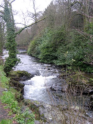
The De Lank River is a small river in north Cornwall, England. It is a tributary of the River Camel and is approximately nine miles (14.5 km) long from its source on Bodmin Moor to its confluence with the Camel two miles (3 km) south of St Breward.

Carlyon is one of four new civil parishes created on 1 April 2009 for the St Austell area of south Cornwall, England, United Kingdom.
Hendraburnick is a farmstead near Davidstow, Cornwall, England. On Hendraburnick Down is the source of the River Camel.

Carrine Common & Penwethers is a Site of Special Scientific Interest (SSSI) in Cornwall, England, UK, noted for its biological characteristics. The 46-hectare (110-acre) site is located at the settlement of Penweathers, within the civil parish of Kea, half a mile south of the city of Truro.
The River Seaton is a river in east Cornwall, England, UK which flows southwards for 11 miles (17 km) into the English Channel.

The River Lerryn is a river in east Cornwall, England, UK, a tributary of the River Fowey. The Lerryn is the largest of the tributaries which enter the estuary of the Fowey. The river is tidal up to the village of Lerryn. The landscape of the Lerryn catchment is rural and includes heathland, moorland and rough pasture in the upper reaches and broadleaf, coniferous and mixed plantation woodland in the lower. This catchment includes four SSSIs, including Redlake Meadows & Hoggs Moor. The Lerryn rises at Fairy Cross on the southern slopes of Bodmin Moor and flows south-southwest until it enters the Fowey estuary.
| Unitary authorities | |
|---|---|
| Major settlements (cities in italics) |
|
| Rivers | |
| Topics | |
50°31′45″N4°42′46″W / 50.52928°N 4.71271°W
| | This Cornwall location article is a stub. You can help Wikipedia by expanding it. |