Borhanuddin Upazila

Last updated • 5 min readFrom Wikipedia, The Free Encyclopedia
Borhanuddin
বোরহানউদ্দিন
Borhanuddin in Barisal division (Bangladesh).svg
Coordinates: 22°30′N90°43.3′E / 22.500°N 90.7217°E / 22.500; 90.7217
Country Flag of Bangladesh.svg  Bangladesh
Division Barisal Division
District Bhola District
Government
  Upazila ChairmanAbul Kalam
  MP (Bhola-2) Ali Azam
Area
  Total
284.66 km2 (109.91 sq mi)
Elevation
[1]
7 m (23 ft)
Population
 (2022) [2]
  Total
265,437
  Density930/km2 (2,400/sq mi)
   Male
126,339 [2]
   Female
139,091 [2]
Time zone UTC+6 (BST)
Postal code
8320 [3]
Area code 04922 [4]
Website borhanuddin.bhola.gov.bd

Borhanuddin (Bengali : বোরহানউদ্দিন) is an upazila (or sub-district) of Bhola District in the Division of Barisal, Bangladesh. [5]

Contents

History

In the eighteenth century, Agha Baqer Khan held numerous jagirs across South Bengal including the area now known as Borhanuddin. During his time, he gifted two rent-free islands in the east and west of present-day Borhanuddin to an Arab family which had arrived in the region. The chief of the family was an Islamic preacher who became renowned among the locals by the name Syed Auliya. [6] The Sufi heritage of Borhanuddin can be recognised through the mazars of many faqirs there such as that of Rahman Faqir in Gunaighar, Kawthar Dawlat Shah Faqir in Mashakira and Muin ad-Din Faqir in Ponra. [7]

Khairullah Hawladar was a Muslim zamindar based in Kalaiya, Patuakhali. His son and successor, Borhanuddin Chowdhury Hawladar, purchased the Kaliganj area of Krishnadevpur Pargana from Kaliprasanna Bhattacharjee, a zamindar of Faridpur. The area was first named Kaliganj by the British administration, and was unified on 15 January 1872. As Kaliganj came under the control of the Hawladars, it started to become known as Borhanuddin Hawladar's Haat. Thus at that time, Borhanuddin Haat was under the Hawladars and Baramganj (later Borhanganj) was under the control of the Hindu Bhattacharyas. Borhanuddin was first established as a replacement thana (police station headquarters) in 1876, due to a flood which heavily damaged the former thana in nearby Borhanganj. [8] It was officially established as a thana in 1928. [5] Around 1939, the closing of the pond ghatla designated for Borhanuddin Jame Masjid caused adverse reactions among the local Muslims. After a few lawsuits, a conflict emerged. A total area of 55 feet on both sides of the road from Onek Tiktokar Poler Para to the present Thana was settled in the name of Borhanuddin Howladar and given the present name (Borhanuddin). [9]

During the Bangladesh Liberation War of 1971, the Borhanuddin Thana Sangram Parishad was founded on 9 March with Reza-e-Karim Chowdhury Chunnu Miah as president, Bashiruddin Miah as vice-president, Muhammad Sirajul Islam as general secretary, Doctor Sayyid Ahmad as treasurer, Anwar Husayn Bhuiyan as publicity officer and Fakhrul Alam Chowdhury and Sirajul Islam Chandu Master as members. Its student wing, the All-Parties Student Sangram Committee, was led by Muhammad Zulfiqar Ali, Tazimuddin Nurnabi, Moslem Hawladar, Jahangir Mahbub, Shahid Rab and Abu. All of the freedom forces of Bhola were based in Borhanuddin such as the force of Abul Kashem of Char Fasson in the Borhanuddin High School and Havildar Majibur Rahman's force in Borhanuddin Primary School. The India-trained faction had possession of modern weaponry. High Command Subedar Siddiqur Rahman led the home Borhanuddin force, battling the army in the villages of Sachra and Deula. Mawlana Maqsufur Rahman played an important role in the Deula victory. Other notable members of the home force of Borhanuddin were Akbar Ali, Shamsul Haq, Ibrahim Miah, Muhammad Siddiq, Nayek Asmat Ali and Lance-Nayek Ziaul Haq. On the morning of 18 October, Siddiqur Rahman and one hundred Bengali freedom fighters besieged the thana. The OC (Officer in Charge) of Borhanuddin Thana flew a white flag, signalling a surrender. Motahar Uddin, Reza-e-Karim Chowdhury MPA and CO Azizul Islam made the officers at the thana surrender. The freedom fighters collected seventy rifles and ammunition. On 22 October, houses in the villages of Tetulia, Betua and Deula were set on fire by the army. Siddiqur Rahman and his force launched an attack at Deula Dighir Par, leading to the death of 50 soldiers from the army including their supporter, the OC (Officer in Charge) of Borhanuddin Thana. The Pakistani army attempted to regain control of the thana which had been under the control of freedom fighters since 18 October. The freedom fighters thought that the Pakistani army would come from Bhola by land, and not river. However, on the morning of 29 October, the Pakistan Army arrived in Borhanuddin via gunboats and launches. The freedom fighters were not informed of this, and the army proceeded towards the thana. The army burnt down Borhanuddin bazaar and Borhanganj, whilst Tansen and Jalil shot at the army car. 71 people were killed on that day by the army, including Sayyid Ahmad Dalalpuri, the Postmaster of Borhanuddin. The army left before noon, and camped at the office of CO Dave, who supported the freedom fighters. Despite Siddiqur Rahman's force consisting of 500 freedom fighters, the brawl at the thana was unsuccessful in Borhanuddin. People from Borhanuddin also contributed to the war in other parts of the country, among the martyred are EBR Lance-Nayek Tafazzal Husayn Chakachashi in Chittagong, EBR Muhammad Sadiq Batamari in Rajshahi and EPR Mukhlisur Rahman in Comilla. [5] [10]

In 1976, the site of the present police station was taken from Shailabala Chaudhurani. [9] The status of Borhanuddin Thana was upgraded to upazila (sub-district) in 1983 as part of the President of Bangladesh Hussain Muhammad Ershad's decentralisation programme. [5]

Geography

Borhanuddin is located at 22°30′00″N90°43′18″E / 22.5000°N 90.7217°E / 22.5000; 90.7217 , 22 kilometres south of Bhola town. It has 37,413 households and a total area of 284.67 km2. It is bounded by Bhola Sadar and Daulatkhan upazilas on the north, Lalmohan on the south, Tazumuddin upazila on the east, and Bauphal upazila of Patuakhali district on the west. [5]

Demographics

Religions in Burhanuddin Upazila (2022) [11]
ReligionPercent
Islam
96.08%
Hinduism
3.91%
Other or not stated
0.01%

According to the 2011 Census of Bangladesh, Burhanuddin upazila had a population of 233,860 living in 48,534 households. The literacy rate was 47.91% and the sex ratio was 1033 females per 1000 males. 38,401 (16.42%) live in urban areas. [12]

Par the 2001 Bangladesh census, Burhanuddin upazila had a population of 244137; male constituted 125828, female 118309; Muslim 230900, Hindu 13174, Buddhist 14 and others 49. [5]

According to the 1991 Bangladesh census, Borhanuddin had a population of 208,478. Males constitute 51.13% of the population, and females 48.87%. The population aged 18 or over was 94,581. Borhanuddin had an average literacy rate of 21.2% (7+ years), compared to the national average of 32.4%. [13]
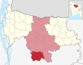
Administration

Burhanuddin Thana was formed in 1928 and it was turned into an upazila on 15 April 1983. [5]

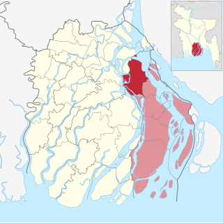
Borhanuddin Upazila is divided into Borhanuddin Municipality and nine union parishads: Boro Manika, Deula, Gongapur, Hasannogor, Kachia, Kutuba, Pakshia, Sachra, and Tobgi. The union parishads are subdivided into 57 mauzas and 46 villages. [14]

Borhanuddin Municipality is subdivided into 9 wards and 13 mahallas. [14]

Chairmen

List of chairmen
NumberNameTerm
01 Hazrat Mawlana Sirajul Islam Sharif1985-1989
02Reza-i-Karim Chowdhury Chunnu Miah1989-1991
03Jasimuddin Haydar20/2/2009-25/3/2014
04Mahabbat Jan Chaudhury25/3/2014-2019
05Abul Kalam2019–present

Notable people

See also

Related Research Articles

<span class="mw-page-title-main">Lakshmipur District</span> District of Bangladesh in Chittagong Division

Lakshmipur is a district in Bangladesh with an area of 1,440 km2. It is bordered by Chandpur to the north, Bhola and Noakhali districts to the south, Noakhali to the east, and Barisal and Bhola districts to the west. Lakshmipur was part of Noakhali until 15 February 1984, when the western part of Noakhali was reorganised from Lakshmipur subdivision into Lakshmipur district to improve administrative efficiency.

<span class="mw-page-title-main">Bhola Sadar Upazila</span> Upazila in Barisal, Bangladesh

Bhola Sadar is an upazila of Bhola District in Barisal Division, Bangladesh. It contains the district headquarters, Bhola.

<span class="mw-page-title-main">Daulatkhan Upazila</span> Upazila in Barisal Division, Bangladesh

Daulatkhan is an upazila of Bhola District in the Division of Barisal, Bangladesh.

<span class="mw-page-title-main">Nalchity Upazila</span> Upazila in Barisal Division, Bangladesh

Nalchity is an upazila of Jhalokati District in the division of Barisal, Bangladesh.

<span class="mw-page-title-main">Rowangchhari Upazila</span> Upazila in Chittagong, Bangladesh

Rowangchhari is an upazila (sub-district) of Bandarban District in southeastern Bangladesh, part of the Chittagong Division.

<span class="mw-page-title-main">Muradnagar Upazila</span> Upazila in Chittagong, Bangladesh

Muradnagar is an upazila of the Comilla District in Chittagong Division, Bangladesh.

<span class="mw-page-title-main">Begumganj Upazila</span> Upazila in Chittagong, Bangladesh

Begumganj is an upazila of the Noakhali District in Bangladesh's Chittagong Division. Begumganj Thana, now an upazila, was established in 1892.

<span class="mw-page-title-main">Senbagh Upazila</span> Upazila in Noakhali District, Chittagong Division, Bangladesh

Senbagh, also spelt Senbag and Senbug, is an upazila of Noakhali District. It is named after its administrative centre, the municipality of Senbagh.

<span class="mw-page-title-main">Kanaighat Upazila</span> Upazila in Sylhet, Bangladesh

Kanaighat is an upazila of Sylhet Division of Bangladesh. It is the second-largest upazila (sub-district) of Sylhet District after Gowainghat Upazila. It is named after the town of Kanaighat, which is also the only municipality in the Upazila.

<span class="mw-page-title-main">Zakiganj Upazila</span> Upazila in Sylhet, Bangladesh

Zakiganj is an upazila of Sylhet District in Sylhet Division, Bangladesh.

<span class="mw-page-title-main">Nawabganj Upazila, Dhaka</span> Upazila in Dhaka, Bangladesh

Nawabganj is an upazila of Dhaka District in the Dhaka Division, Bangladesh.

<span class="mw-page-title-main">Pakundia Upazila</span> Upazila in Kishoreganj District, Bangladesh

Pakundia is an upazila (subdistrict) in Kishoreganj District, Dhaka Division, Bangladesh. Its total land area is 180.52 square kilometres. It has a population of 237,218 residents. It was formed in 1922 as a thana. On 14 September 1983, it was turned into an upazila.

<span class="mw-page-title-main">Bhaluka Upazila</span> Upazila in Mymensingh Division, Bangladesh

Bhaluka is an upazila of the Mymensingh District located in Bangladesh. It is one of the oldest small business hubs in the area.

<span class="mw-page-title-main">Barhatta Upazila</span> Upazila in Mymensingh, Bangladesh

Barhatta is an upazila of Netrokona District, located in Bangladesh's Mymensingh Division.

<span class="mw-page-title-main">Netrokona Sadar Upazila</span> Upazila in Mymensingh, Bangladesh

Netrokona Sadar is an upazila (sub-district) of Netrokona District under Mymensingh Division, Bangladesh.

<span class="mw-page-title-main">Naria Upazila</span> Upazila in Dhaka, Bangladesh

Naria is an upazila of Shariatpur District of the Dhaka Division of Bangladesh. It is named after its administrative centre, the town of Naria.

<span class="mw-page-title-main">Gabtali Upazila</span> Upazila in Rajshahi, Bangladesh

Gabtali is an upazila of the Bogra District, located in Bangladesh's Rajshahi Division. It is named after its administrative centre, the town of Gabtali and is best known as the home upazila of Ziaur Rahman, the late President of Bangladesh. Gabtali town is 7 km north of Bogra.

<span class="mw-page-title-main">Aditmari Upazila</span> Upazila in Rangpur, Bangladesh

Aditmari is the smallest upazila (sub-district) of Lalmonirhat District in Rangpur Division, Bangladesh.

<span class="mw-page-title-main">Kaliganj Upazila, Lalmonirhat</span> Upazila in Rangpur, Bangladesh

Kaliganj is an upazila of the Lalmonirhat District in Rangpur Division, Bangladesh.

<span class="mw-page-title-main">Tanore Upazila</span> Upazila in Rajshahi, Bangladesh

Tanore is an Upazila of Rajshahi District in the Division of Rajshahi, Bangladesh. Tanore police station was established in February 1869 and it was declared sub-district or upazila in 1983.

References

  1. "Geographic coordinates of Bhola Bangladesh". DATEANDTIME.INFO. Retrieved October 3, 2024.
  2. 1 2 3 National Report (PDF). Population and Housing Census 2022. Vol. 1. Dhaka: Bangladesh Bureau of Statistics. November 2023. p. 395. ISBN   978-9844752016.
  3. "Bangladesh Postal Code". Dhaka: Bangladesh Postal Department under the Department of Posts and Telecommunications of the Ministry of Posts, Telecommunications and Information Technology of the People's Republic of Bangladesh. 21 October 2024.
  4. "Bangladesh Area Code". China: Chahaoba.com. 18 October 2024.
  5. 1 2 3 4 5 6 7 Sayed Mustaba Ahmad Khan (2012). "Burhanuddin Upazila". In Sirajul Islam; Miah, Sajahan; Khanam, Mahfuza; Ahmed, Sabbir (eds.). Banglapedia: the National Encyclopedia of Bangladesh (Online ed.). Dhaka, Bangladesh: Banglapedia Trust, Asiatic Society of Bangladesh. ISBN   984-32-0576-6. OCLC   52727562. OL   30677644M . Retrieved 6 January 2025.
  6. উজ্জ্বল নক্ষত্র, Nizami, Niyamat Ullah 2020
  7. মাজার [The Shrine]. Borhanuddin Upazila (in Bengali).
  8. বাংলাদেশের লোকজ সংস্কৃতি ভোলা জেলার. pp. 28–29.
  9. 1 2 Chowdhury, Mohammad Hosain. ভোলা জেলার ইতিহাস (in Bengali).
  10. Ahmed, Sirajuddin (2015). বরিশাল বিভাগের ইতিহাস. Vol. 2. Dhaka: Bhaskar Prakashani.
  11. Population and Housing Census 2022 - District Report: Bhola (PDF). District Series. Dhaka: Bangladesh Bureau of Statistics. June 2024. ISBN   978-984-475-250-4.
  12. "Bangladesh Population and Housing Census 2011 Zila Report – Bhola" (PDF). bbs.gov.bd. Bangladesh Bureau of Statistics.
  13. "Population Census Wing, BBS". Archived from the original on 27 March 2005. Retrieved 10 November 2006.
  14. 1 2 "District Statistics 2011: Bhola" (PDF). Bangladesh Bureau of Statistics. Archived from the original (PDF) on 13 November 2014. Retrieved 14 July 2014.