Bressler, Pennsylvania | |
---|---|
Village | |
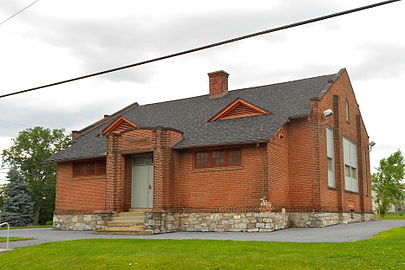
Fire station | |
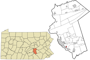
![]() Location in Dauphin County and state of Pennsylvania. | |
Country | United States |
State | Pennsylvania |
County | Dauphin |
Township | Swatara |
Area | |
• Total | 0.32 sq mi (0.82 km2) |
• Land | 0.32 sq mi (0.82 km2) |
• Water | 0.00 sq mi (0.00 km2) |
Elevation | 490 ft (150 m) |
Population | |
• Total | 1,512 |
• Density | 4,769.72/sq mi (1,842.86/km2) |
Time zone | UTC-5 (Eastern (EST)) |
• Summer (DST) | UTC-4 (EDT) |
ZIP Code | 17113 |
FIPS code | 42-08432 |
GNIS feature ID | 1170204 |
Bressler is a Village and census-designated place (CDP) located in Swatara Township, Dauphin County, in the U.S. state of Pennsylvania. The community was formerly part of the census-designated place of Bressler-Enhaut-Oberlin, before splitting into three separate CDPs for the 2010 census. As of the 2010 census the population of Bressler was 1,437. [3]
Bressler is located in southern Dauphin County, in the southwestern part of Swatara Township. It is part of the Harrisburg–Carlisle metropolitan statistical area. It is bordered to the south by the borough of Steelton, to the west by Enhaut, and to the north by Oberlin. It is 5 miles (8 km) southeast of downtown Harrisburg.
Census | Pop. | Note | %± |
---|---|---|---|
2020 | 1,512 | — | |
U.S. Decennial Census [4] [2] |
As of the 2020 U.S. census, there were 1,437 people living in the CDP. The racial makeup of the CDP was 68.9% White, 17.6% Black, 0.1% Native American, 0.5% Asian, 0.1% from some other race and 2.5% from two or more races. 10.3% were Hispanic or Latino of any race.
LebanonCounty is a county in the Commonwealth of Pennsylvania, United States. As of the 2020 census, the population was 143,257. Its county seat is the city of Lebanon. It lies 72 miles northwest of Philadelphia, which is the nearest major city. The county is part of the South Central Pennsylvania region of the state.
Dauphin County is a county in the Commonwealth of Pennsylvania. As of the 2020 census, the population was 286,401. The county seat is Harrisburg, Pennsylvania's state capital and ninth-most populous city. The county was created on March 4, 1785, from part of Lancaster County and was named after Louis Joseph, Dauphin of France, the first son of King Louis XVI. The county is part of the South Central Pennsylvania region of the state.
Bressler-Enhaut-Oberlin was a census-designated place (CDP) in Swatara Township, Dauphin County, Pennsylvania, United States. The population was 2,809 at the 2000 census. For the 2010 census it was split into three CDPs, Bressler, Enhaut, and Oberlin. The area is part of the Harrisburg–Carlisle Metropolitan Statistical Area.
Colonial Park is an unincorporated community and census-designated place (CDP) in Lower Paxton Township, Pennsylvania, United States. The population was 13,229 at the 2010 census. It is part of the Harrisburg–Carlisle Metropolitan Statistical Area. It uses the Harrisburg ZIP code of 17109 and hosts a great deal of the area's retail activity, including the Colonial Park Mall.
Highspire is a borough in Dauphin County, Pennsylvania, United States. The population was 2,741 at the 2020 census, an increase over the figure of 2,399 tabulated in 2010. It is part of the Harrisburg–Carlisle Metropolitan Statistical Area.
Lawnton is an unincorporated area and census-designated place (CDP) in Swatara Township, Dauphin County, Pennsylvania, United States. The population was 3,813 at the 2010 census. It is part of the Harrisburg–Carlisle Metropolitan Statistical Area.
Londonderry Township is a township in Dauphin County, Pennsylvania, United States. The population was 4,890 at the 2020 census.
Lower Paxton is a township in Dauphin County, Pennsylvania, United States. The population was 53,501 at the 2020 census. It is the most populous municipality in Dauphin County and the 17th-most populated municipality in the state.
Lower Swatara Township is a township in Dauphin County, Pennsylvania, United States. The population was 9,557 at the 2020 census. Harrisburg International Airport and Penn State Harrisburg are located within the township. It shares a ZIP Code with the nearby borough of Middletown, and all locations in the township have Middletown addresses.
Paxtonia is an unincorporated community and census-designated place (CDP) in Lower Paxton Township, Dauphin County, Pennsylvania, United States. The population was 5,412 at the 2010 census. It is part of the Harrisburg–Carlisle Metropolitan Statistical Area.
Rutherford is a census-designated place (CDP) in Swatara Township, Dauphin County, Pennsylvania, United States. The area is also known as Rutherford Heights. The population was 4,303 at the 2010 census, an increase over the figure of 3,859 tabulated in 2000. It is part of the Harrisburg–Carlisle Metropolitan Statistical Area.
Susquehanna Township is a township in Dauphin County, Pennsylvania, United States. The population was 26,736 at the time of the 2020 census. This represents a 11.2% increase from the 2010 census count of 24,036. Susquehanna Township has the postal ZIP codes 17109 and 17110, which maintain the Harrisburg place name designation. The township is a suburb of Harrisburg and is connected to Marysville by the Rockville Bridge, the world's longest stone-arch rail bridge at the time of its completion.
Swatara Township is a township in Dauphin County, Pennsylvania. The population was 27,824 at the 2020 census.
Avon is an unincorporated community and census-designated place (CDP) in Lebanon County, Pennsylvania, United States. The population was 1,667 at the 2010 census, a decline from the figure of 2,856 tabulated in 2000.
Campbelltown is an unincorporated community and census-designated place (CDP) in Lebanon County, Pennsylvania, United States. The population was 3,616 at the 2010 census. It is located east of Hershey at the intersection of U.S. Route 322 and Pennsylvania Route 117 and is located in the Harrisburg metropolitan area.
Pleasant Hill is an unincorporated community and census-designated place (CDP) in Lebanon County, Pennsylvania, United States. The population was 2,643 at the 2010 census, up from 2,301 at the 2000 census.
Union Deposit is an unincorporated community and census-designated place in South Hanover Township, Dauphin County, Pennsylvania, United States. It is part of the Harrisburg–Carlisle Metropolitan Statistical Area. As of the 2010 census the population of Union Deposit was 407 residents.
Bressler is a surname. Notable people with the surname include:
Oberlin is an unincorporated community and census-designated place (CDP) located in Swatara Township, Dauphin County, Pennsylvania, United States. The community was part of the census-designated place of Bressler-Enhaut-Oberlin, before it was split into three separate CDPs for the 2010 census. As of the 2010 census, the population was 588.
Enhaut is an unincorporated community and census-designated place (CDP) located in Swatara Township, Dauphin County, Pennsylvania, United States. The community was formerly part of the census-designated place of Bressler-Enhaut-Oberlin, before splitting into three separate CDPs for the 2010 census. As of the 2010 census, the population in Enhaut was 1,007.