Bristol Historic District

Last updated

Bristol Historic District
Bristol Friends.JPG
Bristol Friends Meetinghouse
USA Pennsylvania location map.svg
Red pog.svg
Usa edcp location map.svg
Red pog.svg
LocationRoughly bounded by Pond, Cedar, E. Lincoln Sts., the Delaware River, and E. Mill St., Bristol, Pennsylvania
Coordinates 40°5′53″N74°51′10″W / 40.09806°N 74.85278°W / 40.09806; -74.85278
Area28 acres (11 ha)
ArchitectSloan, Samuel; et al.
Architectural styleMid 19th Century Revival, Late Victorian, Federal
NRHP reference No. 87000665
Added to NRHPApril 30, 1987

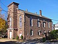
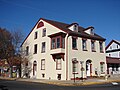
The Bristol Historic District in Bristol, Pennsylvania was included on the National Register of Historic Places in 1987. The district has over 300 buildings, a few dating back to the early eighteenth century. It includes 28 acres, which is the area of the original town as laid out in 1697 and is bounded by the Delaware River, and Lincoln, Pond, Cedar, and Mill Streets. Most of the buildings are residential and only 22 are considered to be non-historic intrusions to the district. [1] [2]

Contents

History

St. James Episcopal Church, designed by Samuel Sloan. St. James Bristol.jpg
St. James Episcopal Church, designed by Samuel Sloan.

Bristol's first European settler, Samuel Clift, operated a ferry across the Delaware River starting in 1681. A Quaker settlement soon grew near the ferry, and in 1697 residents petitioned the Provincial Council to establish the community as the third town in the Pennsylvania Colony. The Bristol Friends Meetinghouse, built in 1711-1714 and partially reconstructed in 1728, is still standing and represents this era of the town's history. Many other buildings burned down in the fire of 1724. [2] [3]

During the last half of the 18th century the town was an important station on the New York to Philadelphia stagecoach route. The Delaware Hotel, at Radcliffe and Mill Street, was originally built in 1765 but has been added to many times since. The 1781 Thomas Belford residence at 200 Mill Street, later turned into a drug store, also represents this era. From the 1780s to the 1820s Bath Springs, just north of the original town, became a famous spa and large residences were built by wealthy Philadelphians and New Yorkers. Shipbuilding was also an important industry. [2]

In 1832 the Delaware Division of the Pennsylvania Canal was completed with Bristol at its southern end, and the town became a transportation hub. Business boomed with hotels, wharves, docks and warehouses lining the riverfront. About 1855 the boom ended as the canal gained access to the Delaware River to the north at New Hope, allowing traffic to New York to bypass Bristol. Many of the houses in the 300 block of Radcliffe Street were built during this period. The 1851 First Baptist Church was designed by Thomas U. Walter. St. James Episcopal Church, designed by Samuel Sloan was completed in 1857. [2] The Dorrance Mansion was completed during the Civil War.

Following the Civil War to town's economy recovered as mills and factories were built along the canal, which provided both water power and transportation. Bristol became the largest center of industry in Bucks County and the town grew with both workers housing and the mansions of industrialists. [1]

Related Research Articles

<span class="mw-page-title-main">Port Deposit, Maryland</span> Historic district in Maryland, United States

Port Deposit is a town in Cecil County, Maryland, United States. It is located on the east bank of the Susquehanna River near its discharge into the Chesapeake Bay. The population was 653 at the 2010 census.

<span class="mw-page-title-main">Bristol, Pennsylvania</span> Borough in Pennsylvania, United States

Bristol is a borough in Bucks County, Pennsylvania, United States. It is located 23 miles (37 km) northeast of Center City Philadelphia, opposite Burlington, New Jersey on the Delaware River.

<span class="mw-page-title-main">Main Line of Public Works</span> United States historic place

The Main Line of Public Works was a package of legislation passed by the Commonwealth of Pennsylvania in 1826 to establish a means of transporting freight between Philadelphia and Pittsburgh. It funded the construction of various long-proposed canal and road projects, mostly in southern Pennsylvania, that became a canal system and later added railroads. Built between 1826 and 1834, it established the Pennsylvania Canal System and the Allegheny Portage Railroad.

<span class="mw-page-title-main">Holmesburg, Philadelphia</span> Neighborhood of Philadelphia, Pennsylvania, US

Holmesburg began as a Village within Lower Dublin Township, Pennsylvania. It is now a neighborhood in the Northeast section of Philadelphia, Pennsylvania, United States. Holmesburg was named in Honor of Surveyor General of Pennsylvania Thomas Holme, who was a cartographer.

<span class="mw-page-title-main">National Register of Historic Places listings in Pennsylvania</span>

This is a list of properties and districts listed on the National Register of Historic Places in Pennsylvania. As of 2015, there are over 3,000 listed sites in Pennsylvania. All 67 counties in Pennsylvania have listings on the National Register.

<span class="mw-page-title-main">Andalusia, Pennsylvania</span> Historic neighborhood in Bensalem Township, Bucks County, Pennsylvania

Andalusia is a historic neighborhood and unincorporated community in Bensalem Township, Pennsylvania, United States. It borders Philadelphia along the Poquessing Creek. It shares the Bensalem Township ZIP Code, 19020, with surrounding CDP's including Cornwells Heights. The area is the southernmost part of the township and of the county. Its boundaries are: Woodhaven Road to the northeast, the Delaware River to the east and south, and Poquessing Creek to the north and west. Interstate 95 - Delaware Expressway runs through its southeastern section near the Delaware River. The neighborhood takes its name from Andalusia, the estate of Philadelphia financier Nicholas Biddle (1786–1844), now preserved as a National Historic Landmark.

<span class="mw-page-title-main">Pennsylvania Canal (Delaware Division)</span> United States historic place

The Delaware Division of the Pennsylvania Canal, more commonly called the Delaware Canal, runs for 60 miles (97 km) parallel to the right bank of the Delaware River from the entry locks near the mouth of the Lehigh River and terminal end of the Lehigh Canal at Easton south to Bristol. At Easton, which today is the home of The National Canal Museum, the Delaware Canal also connected with the Morris Canal built to carry anthracite coal to energy-starved New Jersey industries.

<span class="mw-page-title-main">Samuel Sloan (architect)</span> American architect

Samuel Sloan was a Philadelphia-based architect and best-selling author of architecture books in the mid-19th century. He specialized in Italianate villas and country houses, churches, and institutional buildings. His most famous building—the octagonal mansion "Longwood" in Natchez, Mississippi—is unfinished; construction was abandoned during the American Civil War.

<span class="mw-page-title-main">Lehigh Canal</span> United States historic place

The Lehigh Canal is a navigable canal that begins at the mouth of Nesquehoning Creek on the Lehigh River in the Lehigh Valley and Northeastern regions of Pennsylvania. It was built in two sections over a span of 20 years beginning in 1818. The lower section spanned the distance between Easton and present-day Jim Thorpe. In Easton, the canal met the Delaware and Morris Canals, which allowed anthracite coal and other goods to be transported further up the U.S. East Coast. At its height, the Lehigh Canal was 72 miles (116 km) long.

<span class="mw-page-title-main">Pennsylvania Canal</span>

The Pennsylvania Canal, sometimes known as the Pennsylvania Canal system, was a complex system of transportation infrastructure improvements, including canals, dams, locks, tow paths, aqueducts, and viaducts. The canal was constructed and assembled over several decades beginning in 1824, the year of the first enabling act and budget items.

<span class="mw-page-title-main">Delaware and Lehigh National Heritage Corridor</span> United States National Heritage Area in Pennsylvania

The Delaware & Lehigh Canal National and State Heritage Corridor (D&L) is a 165-mile (266 km) National Heritage Area in eastern Pennsylvania in the United States. It stretches from north to south, across five counties and over one hundred municipalities. It follows the historic routes of the Lehigh and Susquehanna Railroad, Lehigh Valley Railroad, the Lehigh Navigation, Lehigh Canal, and the Delaware Canal, from Bristol northeast of Philadelphia to Wilkes-Barre in the northeastern part of the state.

<span class="mw-page-title-main">King George II Inn</span>

The King George II Inn, located in Bristol, Pennsylvania, is believed to be the oldest continuously operated inn in the United States. It was first established in 1681 as the Ferry House by Samuel Clift. The inn was a main stopping point on the road from New York to Philadelphia. The inn overlooks the Delaware River and is located at the corner of Radcliffe and Mill Streets in the Bristol Historic District.

<span class="mw-page-title-main">Dorrance Mansion</span> Historic house in Pennsylvania, United States

The Dorrance Mansion is a historic house built in 1862–63, located at 300 Radcliffe St., Bristol, Bucks County, Pennsylvania on the Delaware River in the Bristol Historic District. The house represents the lavish life of Bristol's early Victorian industrialists. It is considered one of the grandest homes on Radcliffe Street and is the only example of residential Italianate architecture in Bristol. The house was added to the National Register of Historic Places in 1986.

<span class="mw-page-title-main">Biery's Port Historic District</span> Historic district in Pennsylvania, United States

Biery's Port Historic District is a national historic district located in Catasauqua, Pennsylvania in the Lehigh Valley region of eastern Pennsylvania. The district was added to the National Register of Historic Places in 1984 and includes 90 contributing buildings in the Biery's Port section of Catasauqua.

<span class="mw-page-title-main">Benjamin Riegel House</span> Historic house in Pennsylvania, United States

Benjamin Riegel House is a historical home built in 1832 in Riegelsville, Pennsylvania in the Lehigh Valley region of eastern Pennsylvania.

<span class="mw-page-title-main">Point Pleasant Historic District (Point Pleasant, Pennsylvania)</span> Historic district in Pennsylvania, United States

The Point Pleasant Historic District is a national historic district that is located in Point Pleasant, Plumstead Township and Tinicum Township, Bucks County, Pennsylvania.

<span class="mw-page-title-main">Mountain Top Yard</span>

Mountain Top yard or Penobscot yard is a rail yard in Mountain Top, Pennsylvania. It was built by the Lehigh Coal & Navigation Company (LC&N) in response to an 1837 bill authorizing a right of way and was established by 1840, at least as a construction camp for the Ashley Planes, in support of the construction of the Lehigh and Susquehanna Railroad trackage and operations to join the northern Anthracite Coal Region from barge loading docks along the Susquehanna in Pittston, in the Wyoming Valley, with the Lehigh Canal.

<span class="mw-page-title-main">Phillipsburg Union Station</span>

Phillipsburg Union Station is an active railroad station museum, in Phillipsburg, New Jersey, United States, at 178 South Main Street. Opened in 1914, Union Station was built by the Delaware, Lackawanna & Western Railroad (DL&W) and shared with the Central Railroad of New Jersey (CNJ) and was situated where the lines merged before the bridge crossing the Delaware River. Designed by Frank J. Nies, the architect who produced many of DL&W stations now listed state and federal registers of historic places, the 2+12 story, 3 bay brick building is unusual example of a union station and a representation of early 20th century Prairie style architecture. The Phillipsburg Union Signal Tower, or PU Tower, is nearby, also restored to its original form, and available for tours.

<span class="mw-page-title-main">Pursley's Ferry Historic District</span> Historic district in New Jersey, United States

Pursley's Ferry Historic District is a 61-acre (25 ha) historic district located along Old River Road near Church Road by the Delaware River in Holland Township, Hunterdon County, New Jersey. It was added to the National Register of Historic Places on October 8, 1980 for its significance in architecture, commerce, and transportation. The district includes 4 contributing buildings.

References

  1. 1 2 Bristol Historic District, Delaware and Lehigh National Historic Corridor, A National Register of Historic Places Travel Itinerary, National Park Service
  2. 1 2 3 4 Patrick W. O'Bannon, 1986, NRHP Nomination Form - Bristol Historic District
  3. Bristol Friends Meeting Archived July 24, 2010, at the Wayback Machine accessed 2010-11-04.