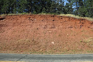
The Morrison Formation is a distinctive sequence of Upper Jurassic sedimentary rock found in the western United States which has been the most fertile source of dinosaur fossils in North America. It is composed of mudstone, sandstone, siltstone, and limestone and is light gray, greenish gray, or red. Most of the fossils occur in the green siltstone beds and lower sandstones, relics of the rivers and floodplains of the Jurassic period.

The Kaibab Limestone is a resistant cliff-forming, Permian geologic formation that crops out across the U.S. states of northern Arizona, southern Utah, east central Nevada and southeast California. It is also known as the Kaibab Formation in Arizona, Nevada, and Utah. The Kaibab Limestone forms the rim of the Grand Canyon. In the Big Maria Mountains, California, the Kaibab Limestone is highly metamorphosed and known as the Kaibab Marble.

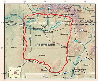
The San Juan Basin is a geologic structural basin located near the Four Corners region of the Southwestern United States. The basin covers 7,500 square miles and resides in northwestern New Mexico, southwestern Colorado, and parts of Utah and Arizona. Specifically, the basin occupies space in the San Juan, Rio Arriba, Sandoval, and McKinley counties in New Mexico, and La Plata and Archuleta counties in Colorado. The basin extends roughly 100 miles (160 km) N-S and 90 miles (140 km) E-W.
The Triassic Lockatong Formation is a mapped bedrock unit in Pennsylvania, New Jersey, and New York. It is named after the Lockatong Creek in Hunterdon County, New Jersey.
The Ringbone Formation is a Campanian geologic formation in southwestern New Mexico.
Igneous rocks are found in Bukit Timah, Woodlands, and Pulau Ubin island. Granite makes up the bulk of the igneous rock. Gabbro is also found in the area and is found in an area called Little Guilin, named for its resemblance to Guilin in South China. This area is in Bukit Gombak. Sedimentary rocks are found on the western part of Singapore, which is mainly made of sandstone and mudstones. It also includes the southwestern area. Metamorphic rocks are found in the northeastern part of Singapore, and also on Pulau Tekong, off the east coast of Singapore. The rocks are mainly made up of quartzite, and also make up the Sajahat Formation.
Fujian is a south eastern coastal province of China. The eastern half of the province is largely covered by Jurassic Period acid volcanic rocks and Cretaceous tuffaceous sandstone. However, there are rocks of a variety of ages including the oldest around 1800 Ma. The deposits from the Triassic are predominantly on land, whereas the older ones are marine sediments.

The Tonto Group is a name for an assemblage of related sedimentary strata, collectively known by geologists as a Group, that comprises the basal sequence Paleozoic strata exposed in the sides of the Grand Canyon. As currently defined, the Tonto groups consists of the Sixtymile Formation, Tapeats Sandstone, Bright Angel Shale, Muav Limestone, and Frenchman Mountain Dolostone. Historically, it included only the Tapeats Sandstone, Bright Angel Shale, and Muav Limestone. Because these units are defined by lithology and three of them interfinger and intergrade laterally, they lack the simple layer cake geology as they are typically portrayed as having and geological mapping of them is complicated.

The Surprise Canyon Formation is a geologic formation that consists of clastic and calcareous sedimentary rocks that fill paleovalleys and paleokarst of Late Mississippian (Serpukhovian) age in Grand Canyon. These strata outcrop as isolated, lens-shaped exposures of rocks that fill erosional valleys and locally karsted topography and caves developed in the top of the Redwall Limestone. The Surprise Canyon Formation and associated unconformities represent a significant period of geologic time between the deposition of the Redwall Limestone and the overlying Supai Group.

The Bass Formation, also known as the Bass Limestone, is a Mesoproterozoic rock formation that outcrops in the eastern Grand Canyon, Coconino County, Arizona. The Bass Formation erodes as either cliffs or stair-stepped cliffs. In the case of the stair-stepped topography, resistant dolomite layers form risers and argillite layers form steep treads. In general, the Bass Formation in the Grand Canyon region and associated strata of the Unkar Group-rocks dip northeast (10°–30°) toward normal faults that dip 60+° toward the southwest. This can be seen at the Palisades fault in the eastern part of the main Unkar Group outcrop area. In addition, thick, prominent, and dark-colored basaltic sills intrude across the Bass Formation.

The El Paso Formation is a geologic formation that is exposed from the Permian Basin of New Mexico and Texas to southeastern Arizona. It preserves fossils dating back to the Ordovician period.

The Montoya Group is a group of geologic formations in westernmost Texas and southern New Mexico. It preserves fossils dating back to the late Ordovician period.

The Sangre de Cristo Formation is a geologic formation in Colorado and New Mexico. It preserves fossils dating back to the late Pennsylvanian to early Permian.
The Mojado Formation is a geologic formation in southwestern New Mexico. It preserves fossils dating back to the early Cretaceous period.
The San Pedro Arroyo Formation is a geologic formation in south-central New Mexico. It preserves fossils dating back to the late Triassic period.
The Bisbee Group is a geologic group in Arizona, Mexico, and New Mexico. It preserves fossils dating back to the early Cretaceous period.
The Sierra Madre Formation is a geologic formation in Chiapas state, southern Mexico. It consists of marine dolomites and limestones. The formation dates to the Middle Cretaceous, spanning from the Aptian of the Early to the Cenomanian of the Late Cretaceous.

The Arroyo del Agua Formation is a geologic formation in New Mexico. It preserves fossils dating back to the early Permian period.
The Love Ranch Formation is a geologic formation in southern New Mexico. It was likely deposited during the late Paleocene and early Eocene epochs.
The Hell-to-Finish Formation is a geologic formation in southwestern New Mexico. It preserves fossils dating back to the early Cretaceous period.


