
Prudhoe is a town and civil parish in the south of Northumberland, England. It is 11 miles (18 km) west of Newcastle upon Tyne and situated on a steep, north-facing hill on the south bank of the River Tyne. Prudhoe had a population of 11,675 at the 2011 census, making it the second largest town in the Tyne Valley after Hexham.

Hexham is a market town and civil parish in Northumberland, England, on the south bank of the River Tyne, formed by the confluence of the North Tyne and the South Tyne at Warden nearby, and close to Hadrian's Wall. Hexham was the administrative centre for the Tynedale district from 1974 to 2009. In 2011, it had a population of 13,097.

Bedlington is a town and former civil parish in Northumberland, England, with a population of 18,470 measured at the 2011 Census.

Mangotsfield is a village and former civil parish in the unitary authority area of South Gloucestershire, in the ceremonial county of Gloucestershire, England, to the north-east of Bristol.

Ellington is a small village in the civil parish of Ellington and Linton, on the coast of Northumberland, England. Ellington is 4 miles (6 km) from Ashington, 6 miles (10 km) from Morpeth and 20 miles (32 km) north of Newcastle upon Tyne.

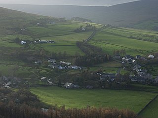
Allendale, often marked on maps as Allendale Town, is a village and civil parish in south west Northumberland, England. It is located within the North Pennines Area of Outstanding Natural Beauty.

Stocksfield is a small village situated close to the River Tyne, about 14 miles (23 km) west of Newcastle upon Tyne in the southern part of Northumberland, England. There are several smaller communities within the parish of Stocksfield, including Branch End, New Ridley, Broomley, Hindley and the Painshawfield Estate. Other villages in Stocksfield's postal district include Bywell, Newton, Mickley, and Hedley on the Hill.

Blanchland is a village in Northumberland, England, on the County Durham boundary. The population of the civil parish at the 2011 census was 135.

Bywell is a village and civil parish in Northumberland, England. It is situated on the north bank of the River Tyne opposite Stocksfield, between Hexham and Newcastle. The parish has a population of around 380 and Newton to the north is now its most populous settlement.

Choppington is a large village and civil parish in Northumberland, England. It is situated 5 miles to the south-east of Morpeth, and north of Bedlington. It was at one time part of the three big mid-Northumberland collieries. In 2011 the parish had a population of 9787.
Ovingham is a village and civil parish in the Tyne Valley of south Northumberland, England. It lies on the River Tyne 10 miles (16 km) east of Hexham with neighbours Prudhoe, Ovington, Wylam and Stocksfield.

Hindley is a small hamlet, comprising around 20 residences. It is in the parish of Stocksfield and is just to the south of Stocksfield in Northumberland with Broomley to the west and Whittonstall to the east. It is south of the River Tyne. Hindley is composed of a large house, Hindley Hall, a farm and a post box.

Riding Mill is a village near Hexham in Northumberland, England. It is part of the civil parish of Broomhaugh and Riding. It is served by Riding Mill railway station and by a frequent bus service on the route from Hexham to Newcastle.
Stocksfield, formerly Broomley and Stocksfield is a civil parish in Northumberland, England. At the 2001 census, the parish, which includes the village of Stocksfield, along with the hamlets of Apperley Dene, Branch End, Broomley, Hindley, New Ridley and Painshawfield, had a population of 3,039, falling slightly to 3,011 at the 2011 Census.

Mickley is a cluster of villages in the civil parish of Prudhoe in Northumberland, England. It lies south of the River Tyne and is accessible via the A695. The electoral ward of Mickley comprises the hamlets of Mickley Square, West Mickley, High Mickley, plus Cherryburn and Eltringham Farm. The population is a little under one thousand. In 1951 the parish had a population of 1862.
Newton on the Moor is a village and former civil parish in Northumberland, England. It is located 5 miles (8 km) south of Alnwick, on the old route of the A1 road although the village has now been bypassed just to the east. The village is now in the civil parish of Newton on the Moor and Swarland, which also includes the village of Swarland, south-west of Newton on the Moor. The population of Newton on the Moor and Swarland parish in 2001 was 822, increasing to 905 at the 2011 Census. The village is a conservation area.

Coxlodge is an area situated between Fawdon, Gosforth and Kenton in Newcastle upon Tyne, in the county of Tyne and Wear, England. Until 1974 it was in Northumberland.
Slaggyford is a village in the civil parish of Knaresdale with Kirkhaugh, in Northumberland, England about 5 miles (8 km) north of Alston, Cumbria.

Widdrington is a village and a civil parish in the county of Northumberland, England. It borders Tritlington and West Chevington and East Chevington parishes to the north, the North Sea to the east, Cresswell and Ellington and Linton parishes to the south, and Widdrington Station and Stobswood parish to the west. In 2011 the parish has a population of 167.

Newton is a village and former civil parish, now the parish of Bywell, in Northumberland, England. It is situated close to the A69 road, 3 miles (5 km) north of Stocksfield and 13 miles (21 km) west of Newcastle upon Tyne. In 1951 the parish had a population of 78. Bywell parish has a population of around 450 and Newton is its most populous settlement. Newton, Newton Hall and Stelling were three separate civil parishes from 1866 to 1 April 1955, when they were merged into the existing Bywell civil parish.

