Northumberland County is located in northeastern New Brunswick, Canada.

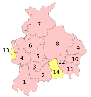
Tynedale was a local government district in Northumberland, England. The district had a resident population of 58,808 according to the 2001 census. The main towns were Hexham, Haltwhistle and Prudhoe. The district contained part of Hadrian's Wall and the southern part of Northumberland National Park.

Hexham is a constituency in Northumberland represented in the House of Commons of the UK Parliament since 2024 by Joe Morris of the Labour Party. As with all constituencies, the constituency elects one Member of Parliament (MP) by the first past the post system of election at least every five years.

Allendale, often marked on maps as Allendale Town, is a village and civil parish in south west Northumberland, England. It is located within the North Pennines Area of Outstanding Natural Beauty.

Stocksfield is a small village situated close to the River Tyne, about 14 miles (23 km) west of Newcastle upon Tyne in the southern part of Northumberland, England. There are several smaller communities within the parish of Stocksfield, including Branch End, New Ridley, Broomley, Hindley and the Painshawfield Estate. Other villages in Stocksfield's postal district include Bywell, Newton, Mickley, and Hedley on the Hill.

A civil parish is a country subdivision, forming the lowest unit of local government in England. There are 14 civil parishes in the ceremonial county of Greater Manchester, most of the county being unparished; Bury, Rochdale, Salford and Stockport are completely unparished. At the 2001 census, there were 129,325 people living in the civil parishes, accounting for 5.2% of the county's population.
A civil parish is a subnational entity, forming the lowest unit of local government in England. There are 219 civil parishes in the ceremonial county of Lancashire; Blackpool is completely unparished; Pendle and Ribble Valley are entirely parished. At the 2001 census, there were 587,074 people living in the 219 parishes, accounting for 41.5 per cent of the county's population.

A civil parish is a subnational entity, forming the lowest unit of local government in England. There are 101 civil parishes in the ceremonial county of West Yorkshire, most of the county being unparished. At the 2001 census, there were 557,369 people living in the parishes, accounting for 26.8 per cent of the county's population.
There are 10 civil parishes in the ceremonial county of Tyne and Wear, most of the county being unparished; North Tyneside and South Tyneside are completely unparished. It is the county of England with the lowest number of civil parishes. At the 2001 census, there were 41,044 people living in the 10 parishes, accounting for 3.8 per cent of the county's population. A civil parish is the lowest unit of local government in England.

Crawcrook is a village in the Metropolitan Borough of Gateshead in Tyne and Wear, England. The population taken at the 2021 Census of the Gateshead ward was 9,058, increasing from 8,841 in 2011. The village was historically part of County Durham until 1974.

Bywell is a village and civil parish in Northumberland, England. It is situated on the north bank of the River Tyne opposite Stocksfield, between Hexham and Newcastle. The parish has a population of around 380 and Newton to the north is now its most populous settlement.

Fawdon is an electoral ward of Newcastle upon Tyne, in the county of Tyne and Wear, England. It is also close to the A1 western bypass. The population of the ward is 10,890, reducing to 10,090 at the 2011 Census, 5.7% of the total population of Newcastle upon Tyne. Car ownership in the area is 53.6%, lower than the city average of 54.7%. Until 1974 it was in Northumberland.

Broadwell is a village and civil parish in the English county of Gloucestershire. It is about 1.5 miles (2.4 km) north of Stow-on-the-Wold, In the 2001 United Kingdom census, the parish had a population of 384. decreasing to 355 at the 2011 census.
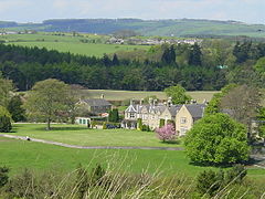
Broomhaugh and Riding is a civil parish in Northumberland, England. It includes the villages of Broomhaugh and Riding Mill. According to the 2001 census it had a population of 936, increasing to 966 at the 2011 census.

Hartley is a village and former civil parish, now in the parish of Seaton Valley in Northumberland, England. The village lies on the A193 road 4 miles (6 km) south of Blyth and 4 miles (6 km) north of Tynemouth. It was a farming and later colliery village but today is part of Seaton Sluice. However it has given its name to the ward of Hartley which covers Seaton Sluice and New Hartley. The population of this ward at the 2011 Census was 4,923. Hartley is sometimes called Old Hartley to distinguish it from New Hartley.

Rochester is a small village and civil parish in north Northumberland, England. It is 5 miles (8 km) north-west of Otterburn on the A68 road between Corbridge and Jedburgh. The village is the site of the Roman fort of Bremenium, built there to protect the important Roman road of Dere Street, which passes through the village.

Horsley is a small village and civil parish in Northumberland, England. The village lies on the top of a south-facing hill above the River Tyne, around 11 miles (18 km) from Newcastle upon Tyne and 12 miles (19 km) from Hexham.