
Clay County is a county located in the U.S. state of Kansas. Its county seat and most populous city is Clay Center. As of the 2020 census, the county population was 8,117. The county was named for Henry Clay, an influential U.S. Senator from Kentucky.

Clay County is located in the U.S. state of Missouri and is part of the Kansas City metropolitan area. As of the 2020 census, the county had a population of 253,335, making it the fifth-most populous county in Missouri. Its county seat is Liberty. The county was organized January 2, 1822, and named in honor of U.S. Representative Henry Clay from Kentucky, later a member of the United States Senate and United States Secretary of State. Clay County contains many of the area's northern suburbs, along with a substantial portion of the city of Kansas City, Missouri. It also owns and operates the Midwest National Air Center in Excelsior Springs.

Geary County is a county located in the U.S. state of Kansas. Its county seat and most populous city is Junction City. As of the 2020 census, the county population was 36,739. The county is named in honor of John Geary, the first mayor of San Francisco, a governor of the Kansas Territory, and the 16th governor of Pennsylvania.

Cloud County is a county located in the U.S. state of Kansas. Its county seat and most populous city is Concordia. As of the 2020 census, the county population was 9,032. The county was named after William Cloud, an officer in the American Civil War.

Wakefield is a city in Clay County, Kansas, United States. As of the 2020 census, the population of the city was 858.

Hays is a city in and the county seat of Ellis County, Kansas, United States. The largest city in northwestern Kansas, it is the economic and cultural center of the region. As of the 2020 census, the population of the city was 21,116. It is also a college town, home to Fort Hays State University.

Manhattan is a city in and the county seat of Riley County, Kansas, United States, although the city extends into Pottawatomie County. It is located in northeastern Kansas at the junction of the Kansas River and Big Blue River. As of the 2020 census, the population of the city was 54,100.
Silver Lake may refer to:

New Milford is a town in Litchfield County, Connecticut, United States. The town, part of Greater Danbury, as well as the New York Metropolitan Area, has a population of 28,115 as of the 2020 census. New Milford lies 14 miles (23 km) north of Danbury on the banks of the Housatonic River, and shares its border with the northeastern shore of Candlewood Lake. It is the largest town in the state of Connecticut in terms of land area at nearly 63.7 mi2 (164.9822 km2). The town center is listed as a census-designated place (CDP).
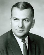
William Henry Avery was an American Republican Party politician who served as the 37th governor of Kansas from 1965 until 1967.

Bowling Green is an unincorporated town in Washington Township, Clay County, Indiana. It is part of the Terre Haute Metropolitan Statistical Area.
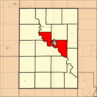
Clay Center Township is a township in Clay County, Kansas, United States. As of the 2000 census, its population was 368.

Milford Lake, also known as Milford Reservoir, is the largest man-made lake in Kansas with 15,700 acres (64 km2) of water. Over 33,000 acres (130 km2) of land resources are managed for quality recreational experiences as well as for protection of the project’s natural and cultural resources. Approximately 70% of the land resources are available for public hunting.

Lloyd Township is one of twelve townships in Dickinson County, Iowa, USA. As of the 2000 census, its population was 616.

Milford Township is one of twelve townships in Dickinson County, Iowa, USA. As of the 2000 census, its population was 869.

K-82 is an east–west state highway in the U.S. state of Kansas. The highway runs 21.076 miles (33.919 km) from K-15 west of Wakefield to U.S. Route 24 (US-24) west of Leonardville. K-82 is an L-shaped route in Clay and Riley counties. The route's east–west and north–south segments are separated by a concurrency with US-77. K-82's east–west segment serves Wakefield and Milford Lake, an impoundment of the Republican River.
Idana is a census-designated place (CDP) in Clay County, Kansas, United States. As of the 2020 census, the population was 54. It is located approximately 6.5 miles west of Clay Center, and 1.5 miles south of US Route 24 along 16th Rd.

Alida is a ghost town in Smoky Hill township of Geary County, Kansas, United States.


