
Alberta is a western province of Canada. With an estimated population of 4,067,175 as of 2016 census, it is Canada's fourth most populous province and the most populous of Canada's three prairie provinces. Its area is about 660,000 square kilometres (250,000 sq mi). Alberta and its neighbour Saskatchewan were districts of the Northwest Territories until they were established as provinces on September 1, 1905. The premier has been Rachel Notley since May 2015.
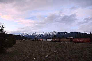
Jasper National Park is the largest national park in the Canadian Rockies, spanning 11,000 km2 (4,200 sq mi). It is located in the province of Alberta, north of Banff National Park and west of Edmonton. The park includes the glaciers of the Columbia Icefield, hot springs, lakes, waterfalls and mountains.

Banff is a town within Banff National Park in Alberta, Canada. It is located in Alberta's Rockies along the Trans-Canada Highway, approximately 126 km (78 mi) west of Calgary and 58 km (36 mi) east of Lake Louise. At 1,400 to 1,630 m above sea level, Banff is the community with the second highest elevation in Alberta, after Lake Louise.

Mount Columbia is the highest point in Alberta, Canada. It is second only to Mount Robson for height and topographical prominence in the Canadian Rockies. It is located on the border between Alberta and British Columbia on the northern edge of the Columbia Icefield. Its highest point, however, lies within Jasper National Park in Alberta.

Mount Brazeau is a mountain in Alberta, Canada.

Mount Hector is a mountain in Banff National Park, Canada. The mountain was named in 1884 by George M. Dawson after James Hector, a geologist on the Palliser Expedition. The mountain is located beside the Icefields Parkway, 17 km (11 mi) north of Lake Louise.
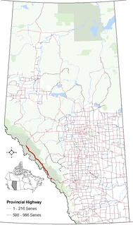
Highway 93 is a north-south highway in Alberta, Canada. It is also known as the Banff-Windermere Parkway south of the Trans-Canada Highway (Highway 1) and the Icefields Parkway north of the Trans-Canada Highway. It travels through Banff National Park and Jasper National Park and is maintained by Parks Canada for its entire length. It runs from the British Columbia border at Vermilion Pass in the south, where it becomes British Columbia Highway 93, to its terminus at the junction with the Yellowhead Highway (Highway 16) at Jasper. The route takes its number from U.S. Route 93, which runs uninterrupted south to central Arizona, and was initially designated as '93' in 1959.

Sheep River Provincial Park is a provincial park located in Alberta, Canada, 23 km west of Turner Valley on highway 546. It is part of the Kananaskis Country park system.
Elbow-Sheep Wildland Provincial Park is a provincial park and wildlife reserve located in the Kananaskis Country in south-western Alberta, Canada.
Mount Lyell is a mountain on the Alberta-British Columbia border, in western Canada. It is located on the Great Divide, which forms the BC-Alberta boundary in this area, in Banff National Park. The mountain is the highest in the Lyell Group, a subrange of the Central Icefields in the Canadian Rockies.

The Ghost River Wilderness Area is a provincially designated wilderness area in the Canadian Rockies of Alberta. It was established in 1967 and it, as one of the three Wilderness Areas of Alberta, has the strictest form of government protection available in Canada. All development is forbidden and only travel by foot is permitted. Hunting and fishing are not allowed. The other two Wilderness Areas are White Goat Wilderness Area and Siffleur Wilderness Area and together the three areas total 249,548.80 acres (100,988.82 ha).
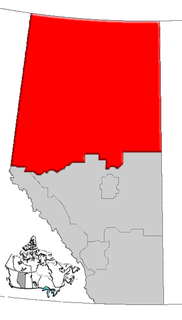
Northern Alberta is a region located in the Canadian province of Alberta.
Mountain View is a hamlet in Alberta, Canada within Cardston County. It is located along Highway 5 approximately 25 kilometres (16 mi) west of Cardston and 20 kilometres (12 mi) east of Waterton Lakes National Park near the United States border. It is also a kickoff point for visitors to Police Outpost Provincial Park, 18 kilometers to the south.
Leslieville is a hamlet in Alberta, Canada within Clearwater County. It is located east of Rocky Mountain House along the Canadian National Railway and has an elevation of 965 metres (3,166 ft).

The Alberta Mountain forests are a temperate coniferous forests ecoregion of Canada.

The White Goat Wilderness Area is a provincially designated wilderness area in the Canadian Rockies of Alberta. It was established in 1961 and it, as one of the three wilderness areas of Alberta, has the strictest form of government protection available in Canada. All development is forbidden and only travel by foot is permitted. Hunting and fishing are not allowed. The other two wilderness areas are Ghost River Wilderness Area and Siffleur Wilderness Area and together the three areas total 249,548.80 acres (100,988.82 ha).
The Siffleur Wilderness Area is a provincially designated wilderness area in the Canadian Rockies of Alberta. It was established in 1961 and it, as one of the three wilderness areas of Alberta, has the strictest form of government protection available in Canada. All development is forbidden and only travel by foot is permitted. Hunting and fishing are not allowed. The other two wilderness areas are White Goat Wilderness Area and Ghost River Wilderness Area and together the three areas total 249,548.80 acres (100,988.82 ha).

The Plains coyote, also known as the brush wolf, is a subspecies of coyote native to the Canadian Prairies of southeastern Alberta,
southern Saskatchewan, and the extreme southwestern corner of Manitoba. Its population in the United States occurs in South Dakota, Montana, Wyoming, Colorado, the northeastern corner of New Mexico; North Dakota ; northwestern Oklahoma, and the
northern Texas Panhandle. It is the largest subspecies, with rather pale fur and bearing large molars and carnassials.