
Alor is the largest island in the Alor Archipelago and is one of the 92 officially listed outlying islands of Indonesia. It is located at the eastern end of the Lesser Sunda Islands chain that runs through southeastern Indonesia, which from the west include such islands as Bali, Lombok, Sumbawa, Komodo, and Flores.

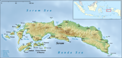
Seram is the largest and main island of Maluku province, despite Ambon Island's historical importance. It is located just north of the smaller Ambon Island and a few other adjacent islands, such as Saparua, Haruku, Nusa Laut and the Banda Islands.

Saparua is an island east of Ambon Island in the Indonesian province of Maluku; the island of Haruku lies between Saparua and Ambon. The main port is in the south at Kota Saparua. The small and uninhabited island of Maolana is located near its southwestern side and Nusa Laut off its southeastern tip.

Tidore is a city, island, and archipelago in the Maluku Islands of eastern Indonesia, west of the larger island of Halmahera. Part of North Maluku Province, the city includes the island of Tidore together with a large part of Halmahera Island to its east. In the pre-colonial era, the Sultanate of Tidore was a major regional political and economic power, and a fierce rival of nearby Ternate, just to the north. Within the city is the provincial capital, Sofifi, situated on the Halmahera territory.

The Obi Islands are a group of 42 islands in the Indonesian province of North Maluku, north of Buru and Ceram, and south of Halmahera. With a total area of 2,817.72 km2, they had a population of 41,455 at the 2010 Census and 50,760 at the 2020 Census. The official estimate as at mid 2023 was 53,182.

Banyumas Regency is an inland regency in the southwestern part of Central Java province in Indonesia. Its capital is the town of Purwokerto, but that town no longer has a central administration and is split over four of the districts within the Regency, with a combined area of 41.65 km2 and a population of 234,467 as of mid-2023. The Regency covers an area of 1,391.15 km2, and had a population of 1,554,527 at the 2010 Census and 1,776,918 at the 2020 Census; the official estimate of the population as of mid-2023 was 1,828,573.

Cilacap Regency is a regency in the southwestern part of Central Java province in Indonesia. Its capital is the town of Cilacap, which had 260,376 inhabitants in mid 2023, spread over three administrative districts.

Solor is a volcanic island located off the eastern tip of Flores island in the Lesser Sunda Islands of Indonesia, in the Solor Archipelago. The island supports a small population that has been whaling for hundreds of years. They speak the languages of Adonara and Lamaholot. There are at least five volcanoes on this island which measures only 40 kilometres by 6 kilometres. The island's area is 226.25 square kilometres, and it had a population of 34,029 at the 2020 Census. The official estimate as at mid 2023 was 35,929.
Sikka is a regency within East Nusa Tenggara province, Indonesia, on the island of Flores. It is bordered to the west by Ende Regency and to the east by East Flores Regency. It covers an area of 1,675.36 km2 and had a population of 300,301 at the 2010 census and 321,953 at the 2020 Census; the official estimate as at mid 2023 was 337,011. The capital is the town of Maumere, which comprises the districts of Alok Barat, Alok and Alok Timur.

North Aceh Regency is a regency in Indonesia's Aceh Province - which was formerly called the Aceh special territory in 1959–2001), and then Nanggroë Aceh Darussalam in 2001–2009), before reverting to Aceh Province in 2009. It is located on the island of Sumatra. The regency covers an area of 3,296.86 square kilometres and had a population of 534,085 at the 2010 census and 602,793 at the 2020 Census; the official estimate as at mid 2023 was 624,582.

South Aceh Regency is a regency in the Aceh province of Indonesia. It is located on the west coast of the island of Sumatra. The regency covers an area of 4,205.33 square kilometres and had a population of 202,251 at the 2010 Census, 224,588 in 2015 and 232,414 at the 2020 Census; the official population estimate in 2023 was 236,933. Its population density was thus 48.1 inhabitants/km2 at the 2010 census, 55.3 inhabitants/km2 at the 2020 census, and 56.3 inhabitants/km2 in 2023. The seat of the regency government is at Tapaktuan.

Ngada Regency is one of the regencies on the island of Flores, East Nusa Tenggara Province, Indonesia. It is bordered by East Manggarai Regency to the west and Nagekeo Regency to the east, with the Flores Sea to the north and the Sawu Sea to the south. The Regency, which covers an area of 1,620.92 km2, had a population of 142,254 at the 2010 census, which increased to 165,254 at the 2020 census; the official estimate as at mid 2023 was 171,174. The town of Bajawa is the capital of Ngada Regency.
Sukamara Regency is one of the thirteen regencies which comprise the Central Kalimantan Province on the island of Kalimantan (Borneo), Indonesia. It was created on 10 April 2002 from the former southwest part of West Kotawaringin Regency. The town of Padang contains the administrative centre of Sukamara Regency, and had a population of 6,555 in mid 2023. The Regency covers an area of 3,827 km2, and had a population of 44,952 at the 2010 Census and 63,464 at the 2020 Census; the official estimate as at mid 2023 was 63,039.

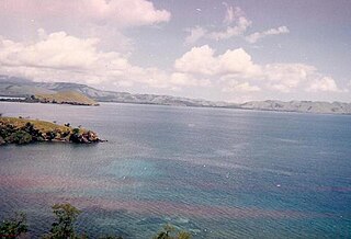
Central Maluku Regency is a regency of Maluku Province of Indonesia. The Regency covers an area of 11,595.57 km2, and had a population of 361,698 at the 2010 Census, and 423,094 at the 2020 Census. The official estimate as at mid 2023 was 430,798. The principal town lies at Masohi, on Seram Island. The regency (kebupaten) is composed of the central part of the island of Seram, the Banda Islands, and the Lease Islands, together with those parts of Ambon Island which are outside the City of Ambon.

South Sorong Regency is a regency of Southwest Papua province of Indonesia. It has an area of 6,570.23 km2, and had a population of 37,900 at the 2010 Census and 52,469 at the 2020 Census; the official estimate as at mid 2023 was 54,277. The administrative centre is the town of Kaibus in Teminabuan District.
West Seram Regency is a regency of Maluku, Indonesia. It is mainly located on Seram, but includes various islands lying to the west of Seram - the largest being Manipa, Kelang and Boano, as well as the smaller islets of Babi, Pua, Masowoi, and Marsegu. It covers a land area of 6,948.40 km2, and had a population of 164,654 at the 2010 Census and 212,393 at the 2020 Census; the official estimate as at mid 2023 was 214,979. The principal town lies at Piru, a port at the northern coast of Latira Bay which is a northwards extension of Piru Bay and almost separates the Huamual Peninsula from the rest of Seram Island. The western sector of the Regency occupies just under 25% of the land area, but held over 42% of the Regency's population at the 2020 Census.
East Seram Regency is a regency of Maluku (province), in Indonesia. It is mainly located on the island of Seram, but also includes smaller islands to the southeast comprising the Gorom and Watubela archipelagoes. The regency covers a land area of 5,779.12 km2, and had a population of 99,065 at the 2010 Census and 137,972 at the 2020 Census; the official estimate as at mid 2023 was 138,580. The principal town lies at Bula, on Seram Island.

Haruku Island is an island in Central Maluku Regency, Maluku Province, Indonesia - lying east of Ambon Island, off the southern coast of Seram and just west of Saparua. It is administered as a single district, Haruku Island District, with a land area of 150 km2 and a population of 24,207 at the 2010 census and 27,390 at the 2020 Census; the official estimate as at mid 2023 was 26,551. The inhabitants of Haruku speak the Haruku language, as well as Indonesian and Ambonese Malay.
Kairatu is a small town and district (kecamatan) on the southwestern coast of the island of Seram. It is part of West Seram Regency. According to the 2010 census, the district had a population of 54,866 people, but the district has subsequently been split and the reduced area had 27,040 inhabitants at the 2020 Census, while the official estimate as at mid 2023 was 26,717. The town itself had 10,266 inhabitants in mid 2022.
Amahai is a village (desa) and an administrative district (kecamatan) on the south coast of the island of Seram, in Central Maluku Regency. The village, which serves as the administrative centre of the eponymous district, lies to the south of Masohi town, both being situated on the coast of Elpaputih Bay, and they are surrounded on the landward sides by Amahai District. Teon Nila Serua District is also a semi-enclave within Amahai District, which surrounds it on all sides except the west. Daily speedboats connect Tulehu with Amahai, which is Seram's main port.