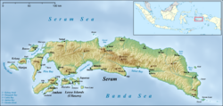
The regency covers a land area of 5,779.12km2, and had a population of 99,065 at the 2010 Census[2] and 137,972 at the 2020 Census;[3] the official estimate as at mid 2023 was 139,777 (comprising 70,595 males and 69,182 females).[1] The principal town lies at Bula, on Seram Island.
Administrative divisions
At the time of the 2010 Census the regency was divided into six districts (kecamatan), an increase from the original four. The first four of these six districts were on the island of Seram; the other two covered the Gorom and Watubela archipelagoes, two groups of smaller islands situated to the southeast of Seram.
Subsequently, six additional districts were created in 2012 by the division of the original six districts, and a further three districts were created in 2014, so that the regency is now divided into fifteen districts (kecamatan), then the sixteenth district was formed in 2025,[4] where which eleven are on the island of Seram (including small offshore islands) and five on the more substantive islands to its southeast. These are tabulated below with their present areas and their populations at the 2010[2] and 2020[3] Censuses, together with the official estimates as at mid 2024.[1] The table also includes the locations of the district administrative centres, the number of administrative villages (all classed as rural desa) in each district, and its post code.
Notes: (a) The 2010 Census populations of Bula Barat and Teluk Waru Districts are included with the figures for Bula District, from which they were cut out. (b) The 2010 Census population of Siwalalat District is included with the figure for Werinama District, from which it was cut out. (c) The 2010 Census populations of Kilmury, Kian Darat, Lian Vitu (or Siritaun Wida Timur), and Ukar Sengan Districts are included with the figures for Seram Timur District, from which they were cut out. (d) The 2010 Census population of Gorom Timur District is included with the figure for Pulau Gorom district, from which it and Pulau Panjang District were cut out. (e) The 2010 Census population of Kesui Watubela (or Wakate) District excludes the figure for Teor District, which was cut out of it. (f) Ukar Sengan District, which was only formed in 2025 and inaugurated on 20 May 2025, was not included in the 2010 and 2020 censuses. Then, the 2024 mid estimate is also not included, even in terms of area, because it is still included as East Seram District.
References
1 2 3 Badan Pusat Statistik, Jakarta, 28 February 2025, Kabupaten Seram Bagian Timur Dalam Angka 2025 (Katalog-BPS 1102001.8107)
This page is based on this Wikipedia article Text is available under the CC BY-SA 4.0 license; additional terms may apply. Images, videos and audio are available under their respective licenses.