
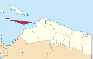
The Barat Daya Islands are a group of islands in the Maluku province of Indonesia. The Indonesian phrase barat daya means 'south-west'.

Anambas Islands Regency is a small archipelago of Indonesia, located 150 nautical miles northeast of Batam Island in the North Natuna Sea between the Malaysian mainland to the west and the island of Borneo to the east. Geographically part of the Tudjuh Archipelago, it is administratively a regency within the Riau Islands Province. It covers a land area of 661.47 square kilometres (255.39 sq mi) and had a population of 37,411 at the 2010 Census and 47,402 at the 2020 Census; the official estimate as at mid 2023 was 50,140. The administrative centre is at Tarempa on Siantan Island.

The Lingga Regency is a group of 600 islands in Indonesia, located south of Singapore and along both sides of the equator, off the eastern coast of Riau Province on Sumatra island. They are due south of the populated Riau Archipelago, known for the industrial island of Batam and the tourist-frequented island of Bintan, although the Lingga Islands themselves are rarely visited due to the infrequent local transportation. The equator goes through the northern tip of Lingga Island, the main island in the archipelago.

The Babar Islands(Indonesian: Kepulauan Babar) are located in Maluku Province, Indonesia between latitudes 7 degrees 31 minutes South to 8 degrees 13 minutes South and from longitudes 129 degrees 30 minutes East to 130 degrees 05 minutes East. The group now constitutes five districts (kecamatan) within the Maluku Barat Daya Regency of Maluku province.
Wetar is a tropical island which belongs to the Indonesian province of Maluku and is the largest island of the Maluku Barat Daya Islands Regency of the Maluku Islands. It lies east of the Lesser Sunda Islands, which include nearby Alor and Timor, but it is politically part of the Maluku Islands. To the south, across the Wetar Strait, lies the island of Timor; at its closest it is 50 km away. To the west, across the Ombai Strait, lies the island of Alor. To the southwest is the very small island of Liran, which is also part of West Wetar District and, further southwest, the small East Timorese island of Atauro. To the north is the Banda Sea and to the east lie Romang and Damar Islands, while to the southeast lie the other principal islands of the Barat Daya Islands. Including Liran and other small offshore islands, Wetar has an area of 2,651.8 km2, and had a population of 7,916 at the 2010 Census and 8,622 at the 2020 Census; the official estimate as at mid 2023 was 11,109. Administratively, Wetar is divided into four of the districts (kecamatan) of the Maluku Barat Daya Regency.

The Letti Islands of Indonesia are part of the Maluku Islands, in southwest Maluku Province. They are also called the "Lemola" Archipelago, from the initial two letters of each of the three main islands, Letti, Moa and Lakor; each of the three islands now constitutes a separate administrative district (kecamatan) within the Maluku Barat Daya Regency

Romang is an island, part of the Barat Daya Islands in Indonesia, located at 7.5833333°S 127.4333333°E, east of Wetar Island. Alternate names in use are Roma, Romonu and Fataluku. The group includes neighbouring smaller islands including Nyata to the west, Mitan to the south, and Maopora, Tellang, Laut, Limtutu and Djuha Islands to the east. Together they form the Kepulauan Roma District within the Barat Daya Islands Regency of the Maluku Province. The district covers a land area of 194.30 km2 and had a population of 4,430 in mid 2023.
Central Hulu Sungai Regency is one of the regencies in the Indonesian province of South Kalimantan. The area is 1,770.77 km2 and the population was 243,460 at the 2010 Census and 258,721 at the 2020 Census; the official estimate as at mid 2023 was 268,360. The administrative centre is the town of Barabai.

The Karimun Regency is located in the Riau Islands Province, Indonesia. Besides the central island of Great Karimun, the regency also includes the island of Kundur and over 240 lesser islands. The district covers a land area of 1,339.9 km2 and a sea area of 6,460 km2, and its population was 212,561 at the 2010 census and 253,457 at the 2020 census; the official estimate as at mid 2023 was 270,121.

Nias Selatan Regency is a regency in North Sumatra province, Indonesia, created on 25 February 2003 by the division of the existing Nias Regency. The regency covers a land area of 2,487.99 square kilometres and according to the 2010 census had a population of 289,708; the 2020 Census showed a population of 360,531, while the official estimate for mid 2023 was 368,834. Its administrative centre is the port of Teluk Dalam. Apart from the southern portion of Nias Island, the regency also includes the smaller Batu Islands to the south, lying between Nias and Siberut; these islands occupy nearly half of the land area of the Regency, but have just 9% of its population.
Yapen Islands Regency is a regency (kabupaten) in Papua Province of eastern Indonesia. It covers an area of 2,432.49 km2 (939.19 sq mi), and had a population of 82,951 at the 2010 Census and 112,676 at the 2020 Census; the official estimate as at mid 2023 was 115,056. It comprises an archipelago which lies in Cenderawasih Bay off the north coast of Western New Guinea.

Manggarai Regency is a regency in East Nusa Tenggara province of Indonesia, situated on the island of Flores. Established in 1958 the regency was reduced in size and population by the separation of the more western districts to form West Manggarai Regency in 2003 and of the more eastern districts to form East Manggarai Regency in 2007. The area of the residual Manggarai Regency is 1,343.83 km2 and its population was 292,037 at the 2010 census and 312,855 at the 2020 census; the official estimate as at mid 2023 was 328,758. The capital of the regency is the town of Ruteng.
Central Halmahera Regency is a regency of North Maluku Province, Indonesia. The regency was originally formed on 15 August 1990 from part of the former North Maluku Regency, but on 25 February 2003 parts of the new regency were split off to form a separate East Halmahera Regency and the city of Kota Tidore Kepulauan. It now comprises just the southern half of the southeastern peninsula of Halmahera Island, together with part of the southern peninsula of that island.

Southeast Maluku Regency is a regency of Maluku, Indonesia. It is coincident with the Kei Islands, except that the city of Tual, although within the Kei Islands geographically and the seat of the Regency's administration, is since 17 July 2007 technically independent of the Regency. The land area of the Regency is 1,031.01 km2, while the sea area administered by the Regency was 3,181 km2; it had a population of 96,442 at the 2010 Census; this increased to 121,511 at the 2020 Census, and the official estimate as at mid 2023 was 129,034.

Tanimbar Islands Regency is a regency of Maluku province, Indonesia, consisting primarily of the Tanimbar Islands. The Regency covers a land area of 10,102 km2, and it had a population of 105,341 at the 2010 Census and 123,572 at the 2020 Census; the official estimate as at mid 2022 was 124,787. The principal town and administrative centre lies at Saumlaki in Tanimbar Selatan District.
Damer, or Damar,, also called Kenli Island, is a small volcanic island in the Barat Daya Islands group in Indonesia's Maluku province, on the southern side of the Banda Sea. It is flanked by four smaller uninhabited islands - one to the east (Layeni), one to the west and two to the south. Together they are called the Damar Islands, and constitute one administrative district within the Maluku Barat Daya Regency, lying on the undersea ridge which forms the most easterly extension of the Lesser Sunda Islands. Continuing the line of the ridge further to the northeast are several small and remote islands at increasing distances from Damer Island; these are Teon Island, Nila Island, tiny 'Nil Desperandum' islet, Serua Island and - far to the north and administered as part of Maluku Tengah Regency - Manuk Island; all of these far-flung islands are isolated stratovolcanoes and are uninhabited. The district has a combined land area of 201.80 km2 and had a population of 5,718 at the 2020 Census; the official estimate as at mid 2023 was 6,362, all on Damer Island itself.
The Sermata Islands or Sematang Islands, is a small group of islands within the Southwest Maluku Regency, part of Maluku (province) in Indonesia. The group is located south of the Damer Islands, east of the Letti Islands and west of the Babar Islands.


