Bulgers, Alabama | |
|---|---|
 Bulgers, Alabama  Bulgers, Alabama | |
| Coordinates: 32°49′07″N85°58′05″W / 32.81861°N 85.96806°W | |
| Country | United States |
| State | Alabama |
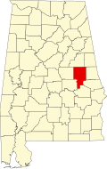
| County | Tallapoosa |
| Elevation | 577 ft (176 m) |
| Time zone | UTC-6 (Central (CST)) |
| • Summer (DST) | UTC-5 (CDT) |
| Area code | 256 |
| GNIS feature ID | 158802 [1] |
Bulgers (also Bulger,Bulgers Mill,Bulgers Mills,Oakchyer) is an unincorporated community in Tallapoosa County, Alabama, United States. [1] [2]