Bungeni

Last updated
Bungeni
A new Village near Bungeni Big tree, Bungeni Village.jpg
A new village near Bungeni Big tree, Bungeni Village
South Africa Limpopo location map.svg
Red pog.svg
Bungeni
South Africa adm location map.svg
Red pog.svg
Bungeni
Coordinates: 23°12′22″S30°13′26″E / 23.206°S 30.224°E / -23.206; 30.224
Country South Africa
Province Limpopo
District Vhembe
Municipality Makhado
Area
[1]
  Total10.94 km2 (4.22 sq mi)
Elevation
700 m (2,300 ft)
Population
 (2011) [1]
  Total23 000
Racial makeup (2011)
[1]
   Black African 99.6%
   Coloured 0.2%
   Indian/Asian 0.1%
   White 0.1%
  Other0.1%
First languages (2011)
[1]
   Tsonga 90.3%
   Venda 7.3%
  Other2.5%
Time zone UTC+2 (SAST)
Postal code (street)
n/a
PO box
n/a

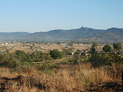
Bungeni is a large sprawling rural settlement situated on top of one of the foothills and tail end of the Soutpansberg mountain in Louis Trichardt, Limpopo Province, South Africa. The Levubu agricultural plantation, where avocado, bananas, litchis, macadamia nuts, peaches and mangoes are grown in abundance is just 3km away north of Bungeni village. It lies 35 km east of Makhado, with the R578 road (South Africa) passing through it. With more than 30 000 people, Bungeni is the largest Tsonga village in Makhado local municipality. In 1994 and in 2016, administrative control of this western portion of Gazankulu has been sub-divided in half and allocated to two Municipalities, first in 1994 to Makhado Local Municipality and in 2016, to the New Malamulele Municipality in the Vhembe district. As of April 2016, the Western portion, known as 'Bungeni West' by the locals, has remained in Makhado local municipality, while the eastern portion, known as 'Bungeni east', has been allocated to the new Malamulele Municipality.

Contents

Sub-villages of Bungeni

Bungeni is a one Super village ruled by Hosi Bungeni, broken down into 22 sub-villages. Hosi Bungeni has jurisdiction over these 22 sub-villages, these sub-villages are run by or presided over by 21 headmen or 'tinduna', who reports directly to Hosi Bungeni. In total, there are more than 22 sub-villages within Bungeni, each with its own 'Nduna' or headman according to their seniority , they are as follows; (1) Sekhunyani (2) Bungeni xikhulu (3) Mabodhlongwa (4)Makhome (5) Xitaci (6) Mtsetweni (7)Xihambanyisi (8) Nwa-Mhandzi (9) Xivambu (10) Njhakanjhaka A (e-Gembani) (11) Njhakanjhaka B (eXavunyami) (12) Wayeni (Bellevue) (13) Mahatlani (14) Nghonyama (New Village, established in 2010) (15) WisaGalaza (16) Dumani (Wayeni) (17) Manyunyu (18) Xingowa (19) Tana na Pulani (New Village, established in 2005) (20) Mandela (New Village, established in 2000) (21) Mahatlani new Stands (New Village, established in 2009) (22) Bungeni Big Tree Village (New Village, established in 2012).

All these sub-villages are collectively known as 'eka-Bungeni' and they fall under Bungeni Traditional Authority, headquartered at Bungeni Xikhulu village, known to the locals as e-Tribal. About half of Bungeni Village is still empty land or unoccupied land, at full capacity, Bungeni village will be a home to more than 80 000 people by 2050. According to the 2015 mid-year population statistics, Bungeni has a population of approximately 30,000 people. The authority to demarcate residential stands, business sites and for any other purposes rest with Chief Bungeni (Mabunda).

Nwaxinyamani village and the headman

In 1960, the South African Government refused to recognize Hosi Chavani Mukhari as a traditional leader for the people of Chavani, Bokisi, Mbhokota and Riverplaats on the basis that the combined people of Chavani, Mbhokota, Bokisi, Riverplaats and their land are too small and therefore they do not qualify for a Traditional Authority of their own. Hosi Chavani was a son of the great Hosinkulu Nhjakanhjaka of Elim/Shirley community whose land starts at Elim and share a border with Bungeni village at a western boundary of Nwaxinyamani village. Hosi Chavani was deployed by his father, Hosi Nhjakanhjaka, with the main aim of expanding the Nhjakanhjaka's area of jurisdiction so that it covers the whole area up until it join Hosi Bungeni's land to the west at Nwaxinyamani village. Initially, the land of Hosinkulu Nhjakanhjaka covers the whole town of Elim and spread beyond Shirley village and covers the whole area known today as Mbhokota, Bokisi, Chavani and Riverplaats. The colonial and later apartheid government feared and always discouraged the formation of large scale Tsonga kingdoms all over South Africa. Because the land of Hosinkulu Nhjakanhjaka was too large the apartheid government divided his land, one at Elim to be ruled by Hosinkulu Nhjakanhjaka and one at Chavani village to be ruled by Hosi Chavani, in that case, a large scale Tsonga kingdom was dealt a blow because the land was divided in order to avoid aggression by Tsongas because a large Tsonga kingdom could not easily be controlled by colonial authorities. The people of Chavani village and their leader, Hosi Chavani Mukhari, approached Hosi Russel Bungeni for assistance. They ask that Hosi Russel Bungeni give away some of his people and his land to the people of Chavani so that Hosi Chavani may be recognized by the South African Government as a Senior traditional leader. Hosi Russel Bungeni agreed to help Hosi Chavani, he gave away Nwaxinyamani village to Hosi Chavani, with strict conditions, that Nwaxinyamani village must be returned to Hosi Russel Bungeni after Hosi Chavani has been recognized by the Government as a Senior Chief. After the transfer of Nwaxinyamani village into Hosi Chavani's land, Nkhensani Tribal Authority became established, in around 1965/66 and the South African Government immediately recognized Hosi Chavani as a Senior Traditional leader for the newly established Nkhensani Tribal Authority, with Nwaxinyamani village as one of Hosi Chavani's land. Thereafter, Tribal Office and a Community Health Centre was built for the people of Chavani by the Government. In around 1968, after Hosi Chavani has been recognized as a Senior Chief by the Government, Nwaxinyamani village has to be returned to Hosi Russel Bungeni but that agreement was not respected by Hosi Chavani, who continued to ignored the 1960 agreement between Hosi Russel Bungeni and himself, i.e. to hand over Nwaxinyamani village back to Hosi Russel Bungeni. It was not until recently, between 2015-2017 that the new Hosi Bungeni, started to engaged the new Hosi Chavani about the 1960 agreement that was entered into by both chief's grandparents. At the moment, both Hosi Chavani and Hosi Bungeni have finally agreed that Nwaxinyamani village must be returned to its old Tribal authority. Negotiations are currently under way between Hosi Bungeni and his former headman, Nwaxinyamani, to finally incorporate Nwaxinyamani village back to Bungeni Tribal Authority.

Education

Bungeni has 5 secondary schools, which are Russel Bungeni High School, Hluvuka High School, Marholeni Secondary School, Bellevue Secondary School and Mahatlani Secondary School. There are 12 primary schools at Bungeni. These are: Njhakanjhaka Primary, Muhluri Primary, Mkhono Higher Primary, Bungeni Primary, Xitaci Primary, Mtsetweni Primary, Xihambanyisi Primary, Ndlavheya Primary, Nwa-Mhandzi Primary, Wayeni Primary, Mahatlani Primary and Masungi Primary.

Related Research Articles

<span class="mw-page-title-main">Limpopo</span> Northernmost (Lebowa) province of South Africa

Limpopo is the northernmost province of South Africa. It is named after the Limpopo River, which forms the province's western and northern borders. The capital and largest city in the province is Polokwane, while the provincial legislature is situated in Lebowakgomo.

<span class="mw-page-title-main">Tsonga people</span> Bantu ethnic group in Africa

The Tsonga people are a Bantu ethnic group primarily native to Southern Mozambique and South Africa. They speak Xitsonga, a Southern Bantu language. A very small number of Tsonga people are also found in Zimbabwe and Northern Eswatini. The Tsonga people of South Africa share some history with the Tsonga people of Southern Mozambique, and have similar cultural practices, but differ in the dialects spoken.

<span class="mw-page-title-main">Hazyview</span> Place in Mpumalanga, South Africa

Hazyview is a sub-tropical farming town in Mpumalanga, South Africa, renowned for its large banana and macadamia nut industries, contributing about 20% of South Africa's bananas and 30% of macadamia output. Bordering the Kruger National Park, the town's name is derived from the shimmering haze that occurs during the heat of summer. Most of the province of Mpumalanga's private game reserves are found just east of Hazyview.

<span class="mw-page-title-main">Thohoyandou</span> Place in Limpopo, South Africa

Thohoyandou is a town in the Limpopo Province of South Africa. It is the administrative centre of Vhembe District Municipality and Thulamela Local Municipality. It is also known for being the former capital of the bantustan of Venda.

<span class="mw-page-title-main">Gazankulu</span> Apartheid-era Tsonga bantustan in South Africa (c. 1973–1994)

Gazankulu was a bantustan in South Africa, intended by the apartheid government to be a semi-independent homeland for the Tsonga people. It was located in both the Northern Transvaal, now Limpopo province and Eastern Transvaal, now Mpumalanga province.

Vonani Bila is a South African author and poet, he was born in 1972 in Shirley Village near Elim Hospital. He is the founder and editor of the poetry journal Timbila and directs the Timbila Poetry Project in Shirley Village, Elim in Limpopo Province. He works as the co-ordinator of the Limpopo NGO Coalition and edits the newspaper Community Gazette. He has written eight story books in English and Tsonga for newly literate adult readers. His poetry has been published in the collection No Free Sleeping. In 2003 Vonani Bila released his first music and poetry CD, 'Dahl Street, Pietersburg'. Bila participated in the 'Poetry Africa 2005', an International festival of poetry held in Durban, South Africa.

<span class="mw-page-title-main">Giyani</span> Place in Limpopo, South Africa

Giyani is a town situated in the North-eastern part of Limpopo Province, South Africa. It is the administrative capital of the Mopani District Municipality, and a former capital of the defunct Gazankulu bantustan. The town of Giyani has seven sections: Section A, Section D1, Section D2, Section E, Section F, Kremetart, and Giyani CBD. Risinga View and Church View are new residential areas in Giyani, but fall under local Traditional Leaders. The Giyani CBD is nicknamed Benstore, and this name is commonly used by residents of the region. Giyani is surrounded by a number of villages with rich Tsonga cultural activities, administered by the Greater Giyani Local Municipality.

<span class="mw-page-title-main">Gungunhana</span>

Ngungunyane, also known as Mdungazwe Ngungunyane Nxumalo, N'gungunhana, or Gungunhana Reinaldo Frederico Gungunhana, was a tribal king and vassal of the Portuguese Empire, who rebelled, was defeated by General Joaquim Mouzinho de Albuquerque and lived out the rest of his life in exile, first in Lisbon, but later on the island of Terceira, in the Azores.

<span class="mw-page-title-main">Vhembe District Municipality</span> District municipality in Limpopo, South Africa

Vhembe is one of the 5 districts of Limpopo province of South Africa. It is the northernmost district of the country and shares its northern border with Beitbridge district in Zimbabwe and on the east with Gaza Province in Mozambique. Vhembe consist of all territories that were part of the former Venda Bantustan, however, two large densely populated districts of the former Tsonga homeland of Gazankulu, in particular, Hlanganani and Malamulele were also incorporated into Vhembe, hence the ethnic diversity of the District. The seat of Vhembe is Thohoyandou, the capital of the former Venda Bantustan. According to 2011 census, the majority of Vhembe residents, about 800,000, speak TshiVenda as their mother language, while 400,000 speak Xitsonga as their home language. However, the Tsonga people are in majority south of Levubu River and they constitute more than 85% of the population in the south of the historic river Levubu, while the Venda are the minority south of Levubu, at 15%. The Northern Sotho speakers number 27,000. The district code is DC34.

Malamulele can refer to the town of Malamulele or the area of Malamulele. Both the town and area are in the Limpopo province of South Africa and predominantly occupied by Tsonga people. Malamulele town has one provincial road and one regional road; the R81 to Giyani and the R524 to Thohoyandou respectively. Malamulele is flanked by two rivers, Levubu River (Rivhubye) to the west and Letaba River to the east, meanwhile the Shingwedzi River runs from Malamulele West to Malamulele East, joining the Olifants in Mozambique on its way to the Indian Ocean. Malamulele is the seat of the Collins Chabane Local Municipality.

<span class="mw-page-title-main">João Albasini</span>

João Albasini (1813–1888). Albasini was born to an Italian family, but according to tradition born in Portugal on a ship leaving for Africa – hence the Portuguese form of his first name. A passionate tradesman and big game hunter, Albasini came to Lourenço Marques in 1831. He revolutionised trade in the Lowveld more than a decade before the first settlers from European descent arrived there. Albasini set up trade routes and infrastructure that reached from the port at Lourenço Marques far into the mainland. Albasini supplied the Tsonga people with ammunition and rifles to protect themselves against other tribes. He also trained and employed 500 Tsonga men to hunt elephant for him, these 500 Tsonga men were all given hunting rifles or guns and Albasini did not control the supply of guns to these hunters because he greatly trusted the Tsonga people.

<span class="mw-page-title-main">Louis Trichardt</span> Place in Limpopo, South Africa

Louis Trichardt, informally shortened to Louis Tri, is a town at the foot of Songozwi, in the Soutpansberg mountain range in the Limpopo province of South Africa. It is the centre of the Makhado Local Municipality, which comprises 16,000 km² with a total population of 270,000 (2001). Louis Trichardt is located in a fertile region where litchis, bananas, mangoes and nuts are produced. The N1 National Route runs through the town. Louis Trichardt is 437 kilometres from Johannesburg and one hour's drive from the Zimbabwean border at Beitbridge. Louis Trichardt was known for a time as Makhado, but it was changed back to Louis Trichardt. Vleifontein, Elim, Tshikota, Madombidzha, Makhado Park and Dzanani surround the town at all directions.

Waterval is a residential township in front of Elim Hospital, it is situated in the Hlanganani district of the former Tsonga homeland of Gazankulu, alongside the R578 road to Giyani in the Limpopo province of South Africa. Waterval includes Njhakanjhaka, Lemana, Elim Hospital, Elim Mall, Hubyeni Shopping centre, Magangeni but excludes Shirley village, which is a separate and stand alone farm, sharing a legal boundary with Waterval and Mbhokota village to the east.

Tiyani is a village situated on the banks of the Middle Letaba Dam in the Hlanganani District of the former Gazankulu homeland and currently form part of the Vhembe District Municipality in the Limpopo province of South Africa.

Hlanganani, also known as Spelonken, is an amalgamation of various large villages which are situated in the north western portion of the former Tsonga homeland of Gazankulu, South Africa. Hlanganani is situated alongside the R578 road to Giyani and Elim.

Valdezia is a sprawling rural settlement situated at the foothills of the Soutpansberg mountain range in Louis Trichardt, Limpopo Province, South Africa. It was formerly known as Albasini before Swiss Missionaries renamed it Valdezia in 1875. The village itself was formally established in 1820 by Tsonga refugees who were fleeing despotic rule from Soshangane. It is roughly 10 km east of Elim Hospital in the Hlanganani district in the former Gazankulu homeland, South Africa. It was the site of a Swiss mission station, and it was named after the Swiss canton of Vaud. Valdezia's population, according to the official census of 2011, currently stands at between 7,600 and 8,000 people. It is considered the birthplace of the written Tsonga language in South Africa.

Temba is a town in City of Tshwane Metropolitan Municipality in the Gauteng province of South Africa.

<span class="mw-page-title-main">Collins Chabane Local Municipality</span> Local municipality in Limpopo, South Africa

Collins Chabane Local Municipality is a local municipality of South Africa. It was established after the August 2016 local elections by the merging of portions of two local municipalities: Thulamela and Makhado. Malamulele is the seat of the municipality.

Hosi Phylia Tinyiko Lwandlamuni Nwamitwa II, also known as Tinyiko Nwamitwa-Shilubana, is the traditional leader of the Valoyi area in Limpopo.

Chabane Jackson Maluleke Hlaneki was a South African politician and Tsonga traditional leader. He represented the African National Congress (ANC) in the National Assembly from 1999 to 2004 and was leader of the Hlaneki tribal authority from 1979 until his death in 2015.

References

  1. 1 2 3 4 "Main Place Bungeni". Census 2011.