Malamulele

Last updated
Malamulele
South Africa Limpopo location map.svg
Red pog.svg
Malamulele
South Africa adm location map.svg
Red pog.svg
Malamulele
Coordinates: 22°58′16″S30°40′25″E / 22.97111°S 30.67361°E / -22.97111; 30.67361
Country South Africa
Province Limpopo
District Vhembe
Municipality Collins Chabane
Established1960
Government
  MayorMoses Maluleke (assassinated in July 2022) (ANC)
Area
[1]
  Total9.57 km2 (3.69 sq mi)
Elevation
167.9 m (550.9 ft)
Population
 (2011) [1]
  Total13,070
  Density1,400/km2 (3,500/sq mi)
Racial makeup (2011)
[1]
   Black African 99.3%
   Coloured 0.2%
   Indian/Asian 0.1%
   White 0.2%
  Other0.2%
First languages (2011)
[1]
   Tsonga 93.7%
   Venda 1.7%
   English 1.2%
  Other3.5%
Time zone UTC+2 (SAST)
Postal code (street)
0982
PO box
0982
Area code 015

Malamulele can refer to the town of Malamulele or the area of Malamulele. [2] Both the town (approximately in the center of the area) and area are in the Limpopo province of South Africa and predominantly occupied by Tsonga people. Malamulele town has one provincial road and one regional road; the R81 to Giyani and the R524 to Thohoyandou (and the Kruger National Park's Punda Maria Gate) respectively. Malamulele is flanked by two rivers, Levubu River (Rivhubye) to the west and Letaba River to the east, meanwhile the Shingwedzi River runs from Malamulele West to Malamulele East, joining the Olifants in Mozambique on its way to the Indian Ocean. Malamulele is the seat of the Collins Chabane Local Municipality.

Contents

There are between 100 and 120 villages in the Malamulele area, with an approximate population of half a million. [3] [4] According to official Stats SA census 2011 results, some 82 Malamulele villages (excluding the township), were home to 206,646 people. [5] In 2001, Thulamela calculated the population according to some 16 main areas (again, excluding the township), supposedly representing the number of independent chiefs, which add up to 199,807 inhabitants.

The Malamulele Area is situated between Giyani on the east, starting at Letaba river, and Thohoyandou on the north-west, starting at Rivhubye river. To the west of Malamulele Area is Waterval, famous for the Elim Hospital. The Cahora Bassa HVDC power transmission line passes through Malamulele from Tete Province to Gauteng. The Malamulele Area formed its own municipality in August 2016, named Collins Chabane, separated from Thulamela but still under the Vhembe District Municipality. [6] [7]

Surrounding areas

To the north-east of Malamulele Town is the Kruger National Park, where it is located 63 km away from the Punda Maria gate, [8] 72 km from the Punda Maria Rest Camp, [9] 99 km from the Shingwedzi Rest Camp, [10] [11] 108 km from the Pafuri Rest Camp [12] [13] and 135 km from the Mopani Rest Camp. [14]

Malamulele Town is 243 km from Polokwane (the capital of Limpopo Province), 453 km from Pretoria and 508 km from Johannesburg.

The shortest straight-line distance from Malamulele Town to the Zimbabwe border is about 60 km and also 60 km to the Mozambique border. Its proximity to Zimbabwe and Mozambique makes Malamulele one of the northernmost towns in South Africa.

History

Malamulele was borne out of the homeland settlement system imposed by the Apartheid government. The people of Malamulele come from both sides of the Rivhubye and were resettled on the eastern side. Most of the people in Phaphazela village come from Malonga in what is now Vuwani. Phaphazela used to be called Malonga in remembrance of their former lands. Some people of the Makhuvele lineage were removed from parts of what is now Thohoyandou. Thus some of the people of Malamulele are the Magwamba, who used to form the Xipilongo (Spelonken) Empire. There has also been communities that were moved from the Kruger National Park to settle in Malamulele. About 40,000 people were moved from west of Rivhubye and settled in Malamulele, whereas about 10,000 [15] [16] were moved from Malamulele and settled in what was to become Venda.

Malamulele was the first town to be built in the former Gazankulu homeland, prior to Giyani. It was named by Chief Risimati Chanyela Mulamula. It was one of the former 7 districts of Gazankulu, namely Nkowankowa, [17] N'wa-Mitwa, [17] Lulekani, [18] Mhala, [19] Hlanganani, [20] Giyani, [21] and of course, Malamulele. [22] At the end of apartheid, Malamulele was renamed to Levubu-Shingwedzi Transitional Local Municipality, after the two rivers. An amalgamation with Thohoyandou led to the Thulamela Local Municipality, which then centralised all administration and services in Thohoyandou.

The years 2000 to 2015 saw consistent objections to the merger with Thohoyandou. In the last few years, the objections went from peaceful applications to the Municipal Demarcation Board to violent protests with property being damaged. The protests were mired with accusations of tribalism and denial, claiming all South African municipalities face service delivery protests. The issue was demonstrated to be imbalanced services between Thohoyandou areas and Malamulele areas. Even with poor service delivery, Thohoyandou areas still enjoyed better service in comparison to Malamulele areas. In July 2015, the Municipal Demarcation Board announced that a new municipality would be formed to serve Malamulele. [23] In August 2016 the new Collins Chabane Local Municipality started to operate in Malamulele, it also serves Vuwani and Bungeni which were under Makhado Local Municipality before.

Geography and climate

Malamulele is a low-lying area at risk of flooding. There are a lot of hills, but no known mountains. The soil structure is mainly sandy grey soil (ntlhava), which the area is named after. Malamulele is approximately 1551.93 km2 in land area. It has a perimeter of 178.283 km2. [24] The area is sparsely populated with a lot of bush between neighbouring settlements. The town has a very dry subtropical climate, specifically a humid subtropical climate (Köppen climate classification: Cwa), with long, hot and rainy summers and short, cool and dry winters.

Political atmosphere

Since 1994, the first time that the people of Malamulele and the rest of black South Africa were ever allowed to vote, the electorate has always voted for the ANC. A few voted for Ximoko xa Rixaka [25] (Whip of the Nation), which has now morphed into XPP (Ximoko Progressive Party). [26] Since then, the majority of Malamulele has voted for the ANC by default, with around 80% of the votes going to the ANC, about 20% higher than the national average.

Demographics

There are between 100 and 120 villages in the Malamulele area, with an approximate population of ± 500,000. [3] [4] According to official Stats SA census 2011 results, some 82 Malamulele villages (excluding the township), were home to 206,646 people. [5] During the same period, Malamulele Town had a population of 13,070. [27] In 2001, or 10 years prior, Thulamela calculated the population according to some 16 main areas (again, excluding the township), supposedly representing the number of independent chiefs, which added up to 199,807 people. During this same period, Malamulele Town had a population of 11,299. [28] These main areas are: Gijana (Magona), Madonsi, Makuleke, Mavambe, Mhinga, Mphambo, Mtititi, Mudavula, Mukhomi, Gumbani, Mulamula, Mulenzhe, Ntlhaveni (Bevhula), Tshikonelo, Xigalo, Xigamane, and Xikundu, thereby recognising 14 Tsonga and 2 Venda (Mulenzhe and Tshikonelo) chiefs. These places account for 1362 km2 [29] [ circular reference ] of Malamulele's 1552 km2 [24] total land area.

For perspective, its northwestern neighbour, Thohoyandou, had a population of 69,453 [30] in 2011, more than double its 2001 population of 32,730. [31] Its eastern neighbour, Giyani, rose from 22,725 [32] to 25,954. [33]

Related Research Articles

<span class="mw-page-title-main">Kruger National Park</span> First national park in South Africa

Kruger National Park is a South African National Park and one of the largest game reserves in Africa. It covers an area of 19,623 km2 (7,576 sq mi) in the provinces of Limpopo and Mpumalanga in northeastern South Africa, and extends 360 km (220 mi) from north to south and 65 km (40 mi) from east to west. The administrative headquarters are in Skukuza. Areas of the park were first protected by the government of the South African Republic in 1898, and it became South Africa's first national park in 1926.

<span class="mw-page-title-main">Limpopo</span> Northernmost province of South Africa

Limpopo is the northernmost province of South Africa. It is named after the Limpopo River, which forms the province's western and northern borders. The capital and largest city in the province is Polokwane, while the provincial legislature is situated in Lebowakgomo.

<span class="mw-page-title-main">Great Limpopo Transfrontier Park</span> Transfrontier park in South Africa, Mozambique qnd Zimbabwe

Great Limpopo Transfrontier Park is a 35,000 km² peace park that is in the process of being formed. It will link the Limpopo National Park in Mozambique, Kruger National Park in South Africa, Gonarezhou National Park, Manjinji Pan Sanctuary and Malipati Safari Area in Zimbabwe, as well as the area between Kruger and Gonarezhou, the Sengwe communal land in Zimbabwe and the Makuleke region in South Africa.

Hilton is a small town that lies between Howick and Pietemaritzburg in the province of KwaZulu-Natal, South Africa. In 1872 the Reverend William Orde Newnham opened Hilton College on a large estate 7.8km north of the town, which is now one of South Africa's leading private schools.

<span class="mw-page-title-main">Thohoyandou</span> Place in Limpopo, South Africa

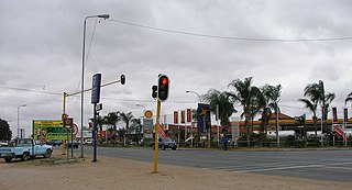
Thohoyandou is a town in the Limpopo Province of South Africa. It is the administrative centre of Vhembe District Municipality and Thulamela Local Municipality. It is also known for being the former capital of the bantustan of Venda.

<span class="mw-page-title-main">Gazankulu</span> Apartheid-era Tsonga bantustan in South Africa (c. 1973–1994)

Gazankulu was a bantustan in South Africa, intended by the apartheid government to be a semi-independent homeland for the Tsonga people. It was located in both the Northern Transvaal, now Limpopo province and Eastern Transvaal, now Mpumalanga province.

<span class="mw-page-title-main">Giyani</span> Town in Limpopo, South Africa

Giyani is a town situated in the north-eastern part of Limpopo Province, South Africa. It is the administrative capital of the Mopani District Municipality and a former capital of the defunct Gazankulu Bantustan. The town of Giyani has seven sections: Section A, Section D1, Section D2, Section E, Section F, Kremetart, and Giyani CBD. Risinga View and Church View are new residential areas in Giyani,but they fall under the local traditional leaders. The Giyani CBD is nicknamed Benstore, and this name is commonly used by residents of the region. Giyani is surrounded by a number of villages with rich Tsonga cultural activities, administered by the Greater Giyani Local Municipality.

<span class="mw-page-title-main">Milnerton</span> Seaside town in the Western Cape, South Africa

Milnerton is a seaside town on Table Bay and is located north of Cape Town in South Africa. It is located 11 kilometres to the north of the city's centre.

<span class="mw-page-title-main">Vhembe District Municipality</span> District municipality in Limpopo, South Africa

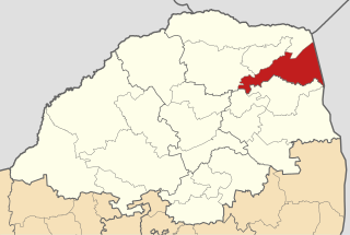
The Vhembe District Municipality is one of the 5 districts of the Limpopo province of South Africa. It is the northernmost district of the country and shares its northern border with the Beitbridge District in Zimbabwe and on the east with the Gaza Province in Mozambique. Vhembe consists of all the territories that were part of the former Venda Bantustan; however, two large densely populated districts of the former Tsonga homeland of Gazankulu, in particular, Hlanganani and Malamulele, were also incorporated into the municipality, hence the ethnic diversity of the district. The seat is Thohoyandou, the capital of the former Venda Bantustan. According to 2011 census, the majority of the municipality's 800,000 inhabitants spoke TshiVenda as their mother language, while 400,000 spoke Xitsonga as their home language. However, the Tsonga people form the majority south of the Levubu River, while the Venda are the minority south of Levubu at 15%. The Sepedi speakers number 27,000. The district code is DC34.

<span class="mw-page-title-main">Skukuza</span> Town in Mpumalanga, South Africa

Skukuza, a town in Mpumalanga located 57 km east of Hazyview at the confluence of the N'waswitshaka and Sabie Rivers, is the administrative headquarters of the Kruger National Park.

<span class="mw-page-title-main">Thulamela Local Municipality</span> Local municipality in Limpopo, South Africa

Thulamela Municipality is a local municipality within the Vhembe District Municipality, in the Limpopo province of South Africa. Its municipal boundaries were greatly altered after the 2016 municipal elections when much of the area that formerly belonged to the municipality, including the town of Malamulele, was incorporated into the newly formed Collins Chabane Local Municipality. It is named after the Thulamela ruins located near the Pafuri Gate of the Kruger National Park.

Nyavani is a small village situated along the R524 route to Punda Maria in the Kruger National Park. The nearest towns from Nyavani are Malamulele to the south and Thohoyandou to the west. Nyavani falls under Collins Chabane Local Municipality. It borders the villages Tshikonelo to the north and Murhaga to the west.

<span class="mw-page-title-main">Shingwedzi River</span> River in South Africa and Mozambique

The Shingwedzi River is a river in Limpopo Province, South Africa, and Gaza Province, Mozambique. It is a left hand tributary of the Olifants River (Rio dos Elefantes) and the northernmost river of its catchment area, joining it at the lower end of its basin. The Shingwedzi is a seasonal river whose riverbed is dry for prolonged periods.

<span class="mw-page-title-main">Shingwedzi</span> Rest camp & rangers post in northern Kruger National Park

Shingwedzi is a rest camp and ranger's post situated in the northern section of the Kruger National Park. The camp is located on the southern bank of the Shingwedzi River, for which it is named, in Limpopo province, South Africa. The surrounding country formerly constituted the Singwitsi Reserve, proclaimed in 1903, which encompassed over 5,000 square kilometers. The region was over-hunted by the end of the 19th century, its big game depleted and its elephant population completely decimated. The name "Shingwedzi" is of Tsonga origin, and was perhaps derived from "Shing-xa-goli", perhaps a local chieftain, and "njwetse", the sound of iron rubbing against iron.

<span class="mw-page-title-main">Lower Sabie</span> Rest camp in Kruger National Park, South Africa

Lower Sabie is one of Kruger National Park's Main rest camps and is situated on the southern bank of the Sabie River, in the southeastern section of the park. It is connected to the main Skukuza camp by the H4-1 tarred road, which is often considered to be the busiest road in the park.

Munster is a quiet coastal town in Ugu District Municipality in the KwaZulu-Natal province of South Africa.

<span class="mw-page-title-main">Collins Chabane Local Municipality</span> Local municipality in Limpopo, South Africa

Collins Chabane Municipality is a local municipality within the Vhembe District Municipality, in the Limpopo province of South Africa. It was established after the August 2016 local elections by merging portions of the Thulamela and Makhado local municipalities. Malamulele is the seat of the municipality.

<span class="mw-page-title-main">Thulamela</span> Archaeological site in South Africa

Thulamela is the most dramatic of around 300 archaeological sites identified in Kruger National Park. It is located on heights south of the Levubu River offering a panoramic view. Sidney Miller led excavations from December 1993 to July 1995, and the site has also been partially reconstructed.

The Phugwane River is a river in Limpopo Province, South Africa. It is a left hand tributary of the Shingwedzi River and the northernmost river of its catchment area, joining it in the middle of its basin. The Phugwane is a seasonal river whose riverbed is dry for prolonged periods.

Olifantsfontein, also known as Clayville, is a small town on the East Rand in the Gauteng Province of South Africa. It is located at the north-western corner of the City of Ekurhuleni Metropolitan Municipality, just north of the Thembisa township. As of the 2011 Census, the town has a population of 14,526 people.

References

  1. 1 2 3 4 "Main Place Malamulele". Census 2011.
  2. Musa Baloyi (27 October 2013). "Malamulele Town". Archived from the original on 2021-12-20 via YouTube.
  3. 1 2 "Zoutnet | News | Municipal status for Malamulele?".
  4. 1 2 "POLICY BRIEF: MAKE MALAMULELE A MUNICIPALITY AND MAKE IT ECONOMICALLY VIABLE". Archived from the original on 2016-08-11.
  5. 1 2 "Census 2011 — Thulamela Local Municipality". census2011.adrianfrith.com.
  6. "SABC News - Malamulele to become a municipality:Saturday 4 July 2015". 4 July 2015. Archived from the original on 2017-10-09. Retrieved 2018-06-14.
  7. "Home". thulamela.gov.za.
  8. "South African National Parks - SANParks - Official Website - Accommodation, Activities, Prices, Reservations". www.sanparks.org.
  9. "South African National Parks - SANParks - Official Website - Accommodation, Activities, Prices, Reservations". www.sanparks.org.
  10. "Shingwedzi Restcamp - Kruger National Park| krugerpark.com". Archived from the original on 2015-07-21. Retrieved 2015-07-19.
  11. "South African National Parks - SANParks - Official Website - Accommodation, Activities, Prices, Reservations". www.sanparks.org.
  12. "South African National Parks - SANParks - Official Website - Accommodation, Activities, Prices, Reservations". www.sanparks.org.
  13. "Pafuri Camp - Kruger Park Reservations". Archived from the original on 2015-09-09. Retrieved 2015-07-19.
  14. "South African National Parks - SANParks - Official Website - Accommodation, Activities, Prices, Reservations". www.sanparks.org.
  15. "The Creation of Tribalism in Southern Africa". publishing.cdlib.org.
  16. "The Creation of Tribalism in Southern Africa". publishing.cdlib.org.
  17. 1 2 Team, Maplandia.com. "Ritavi Region Map: Dan — Serolorolo - South Africa Google Satellite Maps". www.maplandia.com.
  18. Team, Maplandia.com. "Phalaborwa Region Map: Amanda — Welverdiend - South Africa Google Satellite Maps". www.maplandia.com.
  19. Team, Maplandia.com. "Mhala Region Map: Acornhoek — Xanthia - South Africa Google Satellite Maps". www.maplandia.com.
  20. Team, Maplandia.com. "Hlanganani (Gaz Region Map: Ha-Magoro — Shirley - South Africa Google Satellite Maps". www.maplandia.com.
  21. Team, Maplandia.com. "Giyani Region Map: Bend — Zakeni - South Africa Google Satellite Maps". www.maplandia.com.
  22. Team, Maplandia.com. "Malamulele Region Map: Gidjana — Xaswita - South Africa Google Satellite Maps". www.maplandia.com.
  23. "The troubles in Malamulele: An analysis - NEWS & ANALYSIS - Politicsweb". www.politicsweb.co.za.
  24. 1 2 "Google Maps Area Calculator Tool". www.daftlogic.com.
  25. "Ximoko Party (XP)". People's Assembly.
  26. "Why Ximoko Party severed all its ties with the ANC - Capricorn Voice". 15 April 2014.
  27. "Census 2011 — Search Results — "malamulele"". census2011.adrianfrith.com.
  28. "Census 2001 — Search Results — "malamulele"". census2001.adrianfrith.com.
  29. Thulamela Local Municipality
  30. "Census 2011 — Search Results — "thohoyandou"". census2011.adrianfrith.com.
  31. "Census 2001 — Search Results — "thohoyandou"". census2001.adrianfrith.com.
  32. "Census 2001 — Search Results — "giyani"". census2001.adrianfrith.com.
  33. "Census 2011 — Search Results — "giyani"". census2011.adrianfrith.com.