
A Bantustan was a territory that the National Party administration of South Africa set aside for black inhabitants of South Africa and South West Africa, as part of its policy of apartheid. By extension, outside South Africa the term refers to regions that lack any real legitimacy, consisting often of several unconnected enclaves, or which have emerged from national or international gerrymandering.

The Province of the Transvaal, commonly referred to as the Transvaal, was a province of South Africa from 1910 until 1994, when a new constitution subdivided it following the end of apartheid. The name "Transvaal" refers to the province's geographical location to the north of the Vaal River. Its capital was Pretoria, which was also the country's executive capital.

Limpopo is the northernmost province of South Africa. It is named after the Limpopo River, which forms the province's western and northern borders. The capital and largest city in the province is Polokwane, while the provincial legislature is situated in Lebowakgomo.
The Tsonga people are a Bantu ethnic group primarily native to Southern Mozambique and South Africa. They speak Xitsonga, a Southern Bantu language. A very small number of Tsonga people are also found in Zimbabwe and Northern Eswatini. The Tsonga people of South Africa share some history with the Tsonga people of Southern Mozambique, and have similar cultural practices; however they differ on the dialects spoken.

Hazyview is a sub-tropical farming town in Mpumalanga, South Africa, renowned for its large banana and macadamia nut industries, contributing about 20% of South Africa's bananas and 30% of macadamia output. Bordering the Kruger National Park, the town's name is derived from the shimmering haze that occurs during the heat of summer. Most of the province of Mpumalanga's private game reserves are found just east of Hazyview.
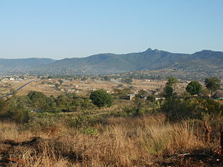
Thohoyandou is a town in the Limpopo Province of South Africa. It is the administrative centre of Vhembe District Municipality and Thulamela Local Municipality. It is also known for being the former capital of the bantustan of Venda.

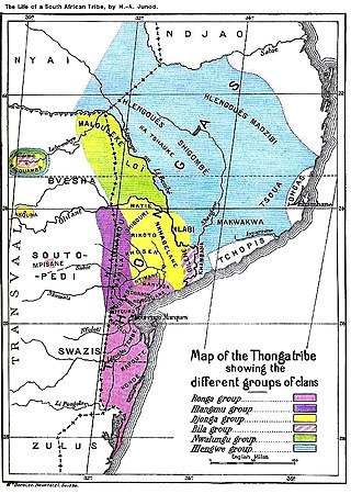
Gazankulu was a bantustan in South Africa, intended by the apartheid government to be a semi-independent homeland for the Tsonga people. It was located in both the Northern Transvaal, now Limpopo province and Eastern Transvaal, now Mpumalanga province.
Vhembe is one of the 5 districts of Limpopo province of South Africa. It is the northernmost district of the country and shares its northern border with Beitbridge district in Zimbabwe and on the east with Gaza Province in Mozambique. Vhembe consist of all territories that were part of the former Venda Bantustan, however, two large densely populated districts of the former Tsonga homeland of Gazankulu, in particular, Hlanganani and Malamulele were also incorporated into Vhembe, hence the ethnic diversity of the District. The seat of Vhembe is Thohoyandou, the capital of the former Venda Bantustan. According to 2011 census, the majority of Vhembe residents, about 800,000, speak TshiVenda as their mother language, while 400,000 speak Xitsonga as their home language. However, the Tsonga people are in majority south of Levubu River and they constitute more than 85% of the population in the south of the historic river Levubu, while the Venda are the minority south of Levubu, at 15%. The Northern Sotho speakers number 27,000. The district code is DC34.

The Venḓa are a Southern African Bantu people living mostly near the South African-Zimbabwean border.
Malamulele can refer to the town of Malamulele or the area of Malamulele. Both the town and area are in the Limpopo province of South Africa and predominantly occupied by Tsonga people. Malamulele town has one provincial road and one regional road; the R81 to Giyani and the R524 to Thohoyandou respectively. Malamulele is flanked by two rivers, Levubu River (Rivhubye) to the west and Letaba River to the east, meanwhile the Shingwedzi River runs from Malamulele West to Malamulele East, joining the Olifants in Mozambique on its way to the Indian Ocean. Malamulele is the seat of the Collins Chabane Local Municipality.

João Albasini (1813–1888). Albasini was born to an Italian family, but according to tradition born in Portugal on a ship leaving for Africa – hence the Portuguese form of his first name. A passionate tradesman and big game hunter, Albasini came to Lourenço Marques in 1831. He revolutionised trade in the Lowveld more than a decade before the first settlers from European descent arrived there. Albasini set up trade routes and infrastructure that reached from the port at Lourenço Marques far into the mainland. Albasini supplied the Tsonga people with ammunition and rifles to protect themselves against other tribes. He also trained and employed 500 Tsonga men to hunt elephant for him, these 500 Tsonga men were all given hunting rifles or guns and Albasini did not control the supply of guns to these hunters because he greatly trusted the Tsonga people.
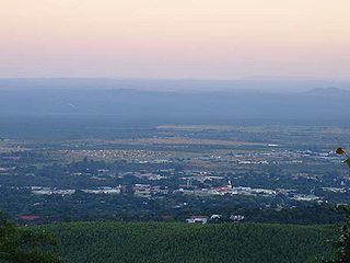
Louis Trichardt, informally shortened to Louis Tri, is a town at the foot of Songozwi, in the Soutpansberg mountain range in the Limpopo province of South Africa. It is the centre of the Makhado Local Municipality, which comprises 16,000 km² with a total population of 270,000 (2001). Louis Trichardt is located in a fertile region where litchis, bananas, mangoes and nuts are produced. The N1 National Route runs through the town. Louis Trichardt is 437 kilometres from Johannesburg and one hour's drive from the Zimbabwean border at Beitbridge. Louis Trichardt was known for a time as Makhado, but it was changed back to Louis Trichardt. Vleifontein, Elim, Tshikota, Madombidzha, Makhado Park and Dzanani surround the town at all directions.
Waterval is a residential township in front of Elim Hospital, it is situated in the Hlanganani district of the former Tsonga homeland of Gazankulu, alongside the R578 road to Giyani in the Limpopo province of South Africa. Waterval includes Njhakanjhaka, Lemana, Elim Hospital, Elim Mall, Hubyeni Shopping centre, Magangeni but excludes Shirley village, which is a separate and stand alone farm, sharing a legal boundary with Waterval and Mbhokota village to the east.
Tiyani is a village situated on the banks of the Middle Letaba Dam in the Hlanganani District of the former Gazankulu homeland and currently form part of the Vhembe District Municipality in the Limpopo province of South Africa.
Bungeni is a large sprawling rural settlement situated on top of one of the foothills and tail end of the Soutpansberg mountain in Louis Trichardt, Limpopo Province, South Africa. The Levubu agricultural plantation, where avocado, bananas, litch, Macadamia nuts, peaches and mangoes are grown in abundance is just 3km away north of Bungeni village. It lies 35 km east of Makhado, with the R578 road passing through it. With more than 30 000 people, Bungeni is the largest Tsonga village in Makhado local municipality. In 1994 and in 2016, administrative control of this western portion of Gazankulu has been sub-divided in half and allocated to two Municipalities, first in 1994 to Makhado Local Municipality and in 2016, to the New Malamulele Municipality in the Vhembe district. As of April 2016, the Western portion, known as 'Bungeni West' by the locals, has remained in Makhado local municipality, while the eastern portion, known as 'Bungeni east', has been allocated to the new Malamulele Municipality.
The R578 is a 100 km long Regional Route in South Africa.
Valdezia is a sprawling rural settlement situated at the foothills of the Soutpansberg mountain range in Louis Trichardt, Limpopo Province, South Africa. It was formerly known as Albasini before Swiss Missionaries renamed it Valdezia in 1875. The village itself was formally established in 1820 by Tsonga refugees who were fleeing despotic rule from Soshangane. It is roughly 10 km east of Elim Hospital in the Hlanganani district in the former Gazankulu homeland, South Africa. It was the site of a Swiss mission station, and it was named after the Swiss canton of Vaud. Valdezia's population, according to the official census of 2011, currently stands at between 7,600 and 8,000 people. It is considered the birthplace of the written Tsonga language in South Africa.

Henri-Alexandre Junod was a Swiss-born South African missionary, ethnographer, anthropologist, linguist and naturalist, stationed for much of his career at Shiluvane Mission Station outside Tzaneen in Limpopo Province. He received an early training in Protestant ministry at Neuchâtel, Basel and Berlin. He was one of the founding members of the Lemana Training College at Njhakanjhaka village near the Township of Waterval at Elim in 1906. Together with Reverend Creux of Valdezia Mission Station, he codified the language of the Tsonga people, which they called 'Thonga', but later renamed Xitsonga. Together with a group of Swiss Missionaries, such as Georges Liengme, he helped in the establishment of Elim Hospital in 1899.

Thulamela is the most dramatic of the around 300 archaeological sites identified in Kruger National Park. It is located on heights south of the Levubu River offering a panoramic view. Sidney Miller led excavations from December 1993 to July 1995, and the site has also been partially reconstructed.
Jackson Hlungwani was a South African sculptor, priest, and founder of the Yesu Galeliya One Aposto in Sanyoni Alt and Omega in New Jerusalem, a site located in Mbhokota in the Limpopo. A deeply religious man, Hlunwani's work is defined by its spirituality and connection to the community.


