
Limpopo is the northernmost province of South Africa. It is named after the Limpopo River, which forms the province's western and northern borders. The capital and largest city in the province is Polokwane, while the provincial legislature is situated in Lebowakgomo.
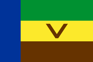
Venda was a Bantustan in northern South Africa, which is fairly close to the South African border with Zimbabwe to the north, while to the south and east, it shared a long border with another black homeland, Gazankulu. It is now part of the Limpopo province. Venda was founded as a homeland by the South African government for the Venda people, speakers of the Venda language. The United Nations and international community refused to recognise Venda as an independent state.
Bethlehem is a town in the eastern Free State province of South Africa that is situated on the Liebenbergs river along a fertile valley just north of the Rooiberg Mountains on the N5 road. It is the fastest growing town in the Free state province, with its target of being the third largest city after Bloemfontein and Welkom.

Lichtenburg is a town situated in North West Province of South Africa. It is the administrative centre of Ditsobotla Local Municipality.
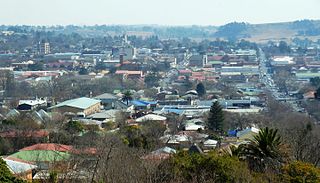
Thohoyandou is a town in the Limpopo Province of South Africa. It is the administrative centre of Vhembe District Municipality and Thulamela Local Municipality. It is also known for being the former capital of the bantustan of Venda.

The Bushveld is a sub-tropical woodland ecoregion of Southern Africa. It encompasses most of Limpopo Province and a small part of the North West Province of South Africa, the Central and North-East Districts of Botswana and the Matabeleland South and part of the Matabeleland North provinces of Zimbabwe. Kruger National Park in South Africa has a number of 'Bushveld' camps. The terms 'bushveld' and 'lowveld' are sometimes used interchangeably, and the line between the two is somewhat blurred, although the lowveld lies in Mpumalanga.
Sibasa is a village in Limpopo Province, South Africa and the former capital city of the Venda bantustan. When Venda was declared independent in 1979, the capital was moved to Thohoyandou.

The Soutpansberg, meaning "Salt Pan Mountain" in Afrikaans, is a range of mountains in far northern South Africa. It is located in Vhembe District, Limpopo. It is named for the salt pan located at its western end. The mountain range reaches the opposite extremity in the Matikwa Nature Reserve, some 107 kilometres (66 mi) due east. The range as a whole had no Venda name, as it was instead known by its sub-ranges which include Dzanani, Songozwi and others. Of late it is however known as Tha vhani ya muno, meaning "mountain of salt".
Vhembe is one of the 5 districts of Limpopo province of South Africa. It is the northernmost district of the country and shares its northern border with Beitbridge district in Zimbabwe and on the east with Gaza Province in Mozambique. Vhembe consist of all territories that were part of the former Venda Bantustan, however, two large densely populated districts of the former Tsonga homeland of Gazankulu, in particular, Hlanganani and Malamulele were also incorporated into Vhembe, hence the ethnic diversity of the District. The seat of Vhembe is Thohoyandou, the capital of the former Venda Bantustan. According to 2011 census, the majority of Vhembe residents, about 800,000, speak TshiVenda as their mother language, while 400,000 speak Xitsonga as their home language. However, the Tsonga people are in majority south of Levubu River and they constitute more than 85% of the population in the south of the historic river Levubu, while the Venda are the minority south of Levubu, at 15%. The Northern Sotho speakers number 27,000. The district code is DC34.

The Venda are a Southern African Bantu people living mostly near the South African-Zimbabwean border.

Phaphala FM is a South African radio station operating through SABC, South Africa's government owned national broadcaster. Phalaphala broadcasts in the Venda language and can be received mainly in Gauteng and Limpopo provinces. The station's Music format is Middle of the Road Format (MOR) with Mid Tempo Bit.
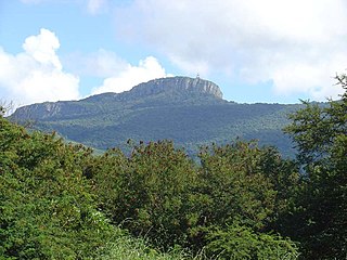
Hanglip, thavha ya VhaDzanani is a prominent mountain peak near Louis Trichardt, South Africa. It is situated in the Vhembe District of Limpopo in the central Soutpansberg range. The peak with radar station, at 1,719 meters a.s.l., forms a conspicuous landmark visible from the town and the N1 national road.
The Dzata Ruins are an archaeological site in Dzanani in the Makhado municipality, Vhembe district, in the north of South Africa.
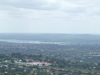
Nandoni Dam, previously known as the Mutoti Dam, is an earth-fill/concrete type dam in Limpopo province, South Africa. It is located on the Luvuvhu River near the villages of ha-Mutoti and ha-Budeli and ha-Mphego just a few kilometres from Thohoyandou in the district of Vhembe. The dam serves primarily for water supply and its hazard potential has been ranked high (3).
Malamulele can refer to the town of Malamulele or the area of Malamulele. Both the town and area are in the Limpopo province of South Africa and predominantly occupied by Tsonga people. Malamulele town has one provincial road and one regional road; the R81 to Giyani and the R524 to Thohoyandou respectively. Malamulele is flanked by two rivers, Levubu River (Rivhubye) to the west and Letaba River to the east, meanwhile the Shingwedzi River runs from Malamulele West to Malamulele East, joining the Olifants in Mozambique on its way to the Indian Ocean. Malamulele is the seat of the Collins Chabane Local Municipality.

The ǀAi-ǀAis/Richtersveld Transfrontier Park is a peace park straddling the border between South Africa and Namibia. It was formed in 2003 by combining the Namibian ǀAi-ǀAis Hot Springs Game Park and the South African Richtersveld National Park. Most of the South African part of the park forms part of the buffer zone of the Richtersveld Cultural and Botanical Landscape World Heritage Site, which measures 5,920 square kilometres (2,290 sq mi). The Fish River Canyon is located in the park, the largest canyon in Africa. A memorandum of understanding was signed on 17 August 2003 by the presidents of South Africa and Namibia, which formalized the establishment of the park. |Ai-|Ais means ‘burning water’, after the hot springs of the same name.
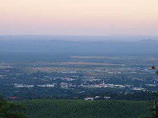
Louis Trichardt, informally shortened to Louis Tri, is a town at the foot of Songozwi, in the Soutpansberg mountain range in the Limpopo province of South Africa. It is the centre of the Makhado Local Municipality, which comprises 16,000 km² with a total population of 270,000 (2001). Louis Trichardt is located in a fertile region where litchis, bananas, mangoes and nuts are produced. The N1 National Route runs through the town. Louis Trichardt is 437 kilometres from Johannesburg and one hour's drive from the Zimbabwean border at Beitbridge. Louis Trichardt was known for a time as Makhado, but it was changed back to Louis Trichardt. Vleifontein, Elim, Tshikota, Madombidzha, Makhado Park and Dzanani surround the town at all directions.
Makhado was a 19th-century chief in the Singo dynasty of the Vendas. They ruled over the Dzanani "district" of the Zoutpansberg region of South Africa. He was the youngest son of khosi Ramabulana who died in 1864 when Makhado was about 25. Makhado's mother was Limani, noted for her political intrigue. Makhado's first wife was Nwaphunga. According to Venda historian M. H. Nemudzivhadi, Nwaphunga conspired with a pro-Boer faction among the Venda, and poisoned him in 1895.
Schoemansdal was a settlement situated 16 km west of Louis Trichardt (Makhado), which had its origins during the Great Trek. It existed from 1848 to 1867, and functioned as the capital of an autonomous region until the S.A.R. Volksraad was established, when the outpost came under the supervision and regulations of the central government. The settlement was evacuated after only thirty years when attacked by Venda militants. The government rendered indecisive support and the town as torched by Katze-Katze on the night of 15 July 1867.
Before 1994, South Africa had only four provinces: Cape Province, Natal Province, Orange Free State and Transvaal. Each province had its own identifying lettering: Cape – C, Natal – N, Orange Free State – O and Transvaal – T.


