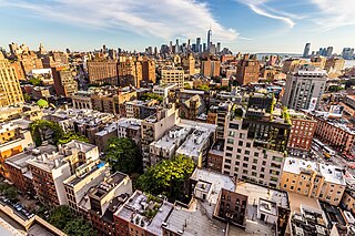
Greenwich Village, or simply The Village, is a neighborhood on the west side of Lower Manhattan in New York City, bounded by 14th Street to the north, Broadway to the east, Houston Street to the south, and the Hudson River to the west. Greenwich Village also contains several subsections, including the West Village west of Seventh Avenue and the Meatpacking District in the northwest corner of Greenwich Village.

Wiltshire is a ceremonial county in South West England. It borders Gloucestershire to the north and the north-west, Oxfordshire to the north-east, Berkshire to the east, Hampshire to the south-east, Dorset to the south, and Somerset to the west and the south-west. The largest settlement is Swindon, and Trowbridge is the county town.

Bridgeview is a village in Cook County, Illinois, United States. It is located approximately 15 miles (24 km) southwest of the Chicago Loop. As of the 2020 census, the village population was 17,027.

Oak Lawn is a village in Cook County, Illinois, United States. The population was 58,362 at the 2020 census. Oak Lawn is a suburb of Chicago, located southwest of the city. It shares borders with the city in two areas but is surrounded mostly by other suburbs.
Oak Park is a village in Cook County, Illinois, adjacent to Chicago. It is the 26th-most populous municipality in Illinois, with a population of 54,583 as of the 2020 U.S. Census estimate. Oak Park was first settled in 1835 and later incorporated in 1902, when it separated from Cicero. It is closely tied to the smaller town of River Forest, sharing Oak Park and River Forest High School. Architect Frank Lloyd Wright and his wife settled in Oak Park in 1889, and his work heavily influenced local architecture and design, including the Frank Lloyd Wright Home and Studio. Over the years, rapid development was spurred by railroads and streetcars connecting the village to jobs in nearby Chicago. In 1968, Oak Park passed the Open Housing Ordinance, which helped devise strategies to integrate the village rather than resegregate.

Tinley Park is a village in Cook County, Illinois, United States, with a small portion in Will County. The village is a suburb of Chicago. Per the 2020 census, the population was 55,971. It is one of the fastest growing suburbs southwest of Chicago. In 2009 BusinessWeek named Tinley as the best place in America to raise a family.
Carol Stream is a village in DuPage County, Illinois, United States, and a suburb of Chicago. Carol Stream was incorporated on January 5, 1959, and named after its founder's daughter. Per the 2020 census, the population was 39,854.

Glen Ellyn is a village in DuPage County, Illinois, United States. A suburb located 24 miles (39 km) due west of downtown Chicago, the village has a population of 28,846 as of the 2020 Census.

Glendale Heights is a village in DuPage County, Illinois, United States. Per the 2020 census, the population was 33,176. The village is almost entirely residential, and is a far west suburb of Chicago.

Algonquin is a village in McHenry and Kane counties, Illinois, in the United States. It is a suburb of Chicago, located approximately 40 miles (64 km) northwest of the Loop. As of the 2020 census, the village's population was 29,700.

Mundelein is a village in Lake County, Illinois, United States and a northern suburb of Chicago. Per the 2020 census, the population was 31,560. It is approximately thirty-five miles northwest of Chicago.

Romeoville is a village in Will County, Illinois, United States. The village is located 26 mi (42 km) southwest of Chicago on the Gateway Wetlands, directly west of the Des Plaines River. Per the 2020 census, the population was 39,863. It is located in the southwest suburban area of Chicago near Interstate 55 and Interstate 355.

Etobicoke is an administrative district and former city within Toronto, Ontario, Canada. Comprising the city's west-end, Etobicoke is bordered on the south by Lake Ontario, on the east by the Humber River, on the west by Etobicoke Creek, the cities of Brampton, and Mississauga, the Toronto Pearson International Airport, and on the north by the city of Vaughan at Steeles Avenue West.

Warwickshire is a ceremonial county in the West Midlands of England. It is bordered by Staffordshire and Leicestershire to the north, Northamptonshire to the east, Oxfordshire and Gloucestershire to the south, and Worcestershire and the West Midlands county to the west. The largest settlement is Nuneaton and the county town is Warwick.

The R81 is a provincial route in Limpopo, South Africa that connects Polokwane with the R524 at Nyavani via Giyani.
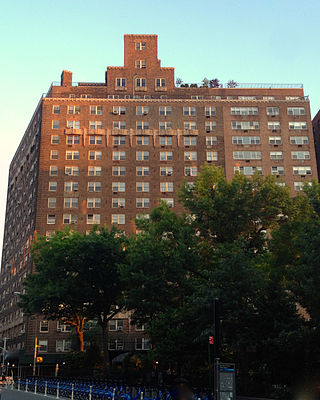
The West Village is a neighborhood in the western section of the larger Greenwich Village neighborhood of Lower Manhattan, New York City. The West Village is bounded by the Hudson River to the west and 14th Street to the north. The eastern boundary is variously cited as Greenwich Avenue, Seventh Avenue, or Sixth Avenue, while the southern boundary is either Houston Street or Christopher Street.

Rishra is a city and a municipality in Srirampore subdivision of Hooghly district in the Indian state of West Bengal. It is a part of the area covered by Kolkata Metropolitan Development Authority (KMDA).

Lansing is a neighbourhood in Toronto, Ontario, Canada. It originated as a minor settlement of a store, other services and a post office at the corner of Yonge Street and Sheppard Avenue and later got consolidated with Toronto as sprawling development took place. A larger area was designated as the postal village of Lansing. The City of Toronto labels it as Lansing-Westgate for neighbourhood planning purposes with the boundaries Yonge Street to the east, Highway 401 to the south, Bathurst Street to the west and Burnett Avenue to the north.

Ludford is a village and civil parish in the East Lindsey district of Lincolnshire, England. The parish is composed of the villages of Ludford Magna and Ludford Parva.

Chinsurah Mogra is a community development block that forms an administrative division in Chinsurah subdivision of Hooghly district in the Indian state of West Bengal.


