
South Africa occupies the southern tip of Africa, its coastline stretching more than 2,850 kilometres from the desert border with Namibia on the Atlantic (western) coast southwards around the tip of Africa and then northeast to the border with Mozambique on the Indian Ocean. The low-lying coastal zone is narrow for much of that distance, soon giving way to a mountainous escarpment that separates the coast from the high inland plateau. In some places, notably the province of KwaZulu-Natal in the east, a greater distance separates the coast from the escarpment. Although much of the country is classified as semi-arid, it has considerable variation in climate as well as topography. The total land area is 1,220,813 km2 (471,359 sq mi). It has the 23rd largest Exclusive Economic Zone of 1,535,538 km2 (592,875 sq mi).

Palm Desert is a city in Riverside County, California, United States, in the Coachella Valley, approximately 14 miles (23 km) east of Palm Springs, 121 miles (195 km) northeast of San Diego and 122 miles (196 km) east of Los Angeles. The population was 48,445 at the 2010 census, up from 41,155 at the 2000 census. The city was one of the state's fastest growing in the 1980s and 1990s, beginning with 11,801 residents in 1980, doubling to 23,650 in 1990, 35,000 in 1995, and nearly double its 1990 population by 2000. A major center of growth in the Coachella Valley, Palm Desert is a popular retreat for "snowbirds" from colder climates, who swell its population by an estimated 31,000 each winter. Palm Desert has seen more residents become "full-timers", mainly from the coasts and urban centers of California, who have come for both affordable and high-valued homes.

Winter Haven is a city in Polk County, Florida, United States. It is fifty-one miles east of Tampa. The population was 33,874 at the 2010 census. According to the U.S. Census Bureau's 2019 estimates, this city had a population of 44,955, making it the second most populated city in Polk County. It is a principal city of the Lakeland-Winter Haven, Florida Metropolitan Statistical Area.

Hot Springs is a city in and county seat of Fall River County, South Dakota, United States. As of the 2010 census, the city population was 3,711. In addition, neighboring Oglala Lakota County contracts the duties of Auditor, Treasurer and Register of Deeds to the Fall River County authority in Hot Springs.

The Eastern Cape is one of the provinces of South Africa. Its capital is Bhisho, but its two largest cities are East London and Port Elizabeth.
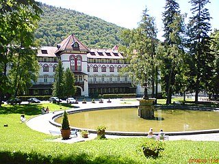
Sinaia is a town and a mountain resort in Prahova County, Romania. It is situated in the historical region of Muntenia. The town was named after the Sinaia Monastery of 1695, around which it was built. The monastery in turn is named after the Biblical Mount Sinai. King Carol I of Romania built his summer home, Peleș Castle, near the town in the late nineteenth century.

Mossel Bay is a harbour town of about 99,319 people on the Southern Cape of South Africa. It is in an important tourism and farming region of the Western Cape Province. Mossel Bay lies 400 kilometres east of the country's seat of parliament, Cape Town, and 400 km west of Gqeberha, the largest city in the Eastern Cape. The older parts of the town occupy the north-facing side of the Cape St Blaize Peninsula, whilst the newer suburbs straddle the Peninsula and have spread eastwards along the sandy shore of the Bay.

Namaqualand is an arid region of Namibia and South Africa, extending along the west coast over 1,000 km (600 mi) and covering a total area of 440,000 km2 (170,000 sq mi). It is divided by the lower course of the Orange River into two portions – Little Namaqualand to the south and Great Namaqualand to the north.

Badplaas, also known as eManzana and eBhadini is a small town on the R38 road in eastern Mpumalanga, South Africa. It was established in 1876 on the Seekoeispruit, in the foothills of the Dlomodlomo Mountains, at the site of a sulphur spring that delivers ±30,000 litres of hot water per hour. Multiple sulphur springs are found around the area, including the one situated at Mkhingoma on the Mkhomazana river.

Middle Park is a high basin in the Rocky Mountains of north-central Colorado in the United States. It is located in Grand County, on the southwest slope of Rocky Mountain National Park, approximately 50 miles (80 km) west of Boulder.
The Park Range, elevation approximately 12,000 feet (3,700 m), is a mountain range in the Rocky Mountains of northwestern Colorado in the United States. The range forms a relatively isolated part of the Continental Divide, extending north-to-south for approximately 40 miles (64 km) along the boundary between Jackson (east) and Routt counties. It separates North Park in the upper basin of the North Platte River on the east from the Elk River basin in the watershed of the Yampa River the west. It rises steeply out of the Yampa River basin, forming a climatic barrier that receives much snowfall in winter. The northern end of the range lies in Wyoming and is known as the Sierra Madre Range.
Aliwal North is a town in central South Africa on the Orange River, Eastern Cape Province. It is a medium-sized commercial centre in the Northernmost part of the Eastern Cape

Seefeld in Tirol is an old farming village, now a major tourist resort, in Innsbruck-Land District in the Austrian state of Tyrol with a local population of 3,312. The village is located about 17 km (11 mi) northwest of Innsbruck on a plateau between the Wetterstein mountains and the Karwendel on a historic road from Mittenwald to Innsbruck that has been important since the Middle Ages. It was first mentioned in 1022 and since the 14th century has been a pilgrimage site, benefiting not only from the visit of numerous pilgrims but also from its stacking rights as a trading station between Augsburg and the Venice. Also since the 14th century, Tyrolean shale oil has been extracted in the area. Seefeld was a popular holiday resort even before 1900 and, since the 1930s, has been a well known winter sports centres and amongst the most popular tourist resorts in Austria. The municipality, which has been the venue for several Winter Olympics Games, is the home village of Anton Seelos, the inventor of the parallel turn.
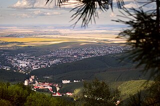
Belokurikha is a town and a balneological resort in the Altai region of Russia, located on the Bolshaya Belokurikha River 250 kilometers (160 mi) south of Barnaul, the administrative center of the krai. As of the 2010 Census, its population was 14,661.

Devin is a spa town in Smolyan Province in the far south of Bulgaria. It is the administrative centre of the homonymous Devin Municipality. As of December 2009, the town has a population of 7,054 inhabitants.

Mineral spas are spa resorts developed around naturally occurring mineral springs. Like seaside resorts, they are mainly used recreationally although they also figured prominently in prescientific medicine.

Sugarloaf Provincial Park is an 11.5-square-kilometre (4.4 sq mi) all-season provincial park located in Campbellton, New Brunswick. It opened in 1972.

Chintsa is a village in the Wild Coast region of the Eastern Cape province, South Africa. It is situated 38 km north-east from East London and 10 km north from Gonubie,at the mouth of the Cintsa river.

Umbogintwini is a town near Durban in KwaZulu-Natal, South Africa. Its post office received the corrected name in 1997. It is best known for the industrial complex which has Acacia, Chemical Initiatives and Sammar warehouses.

Nwanedi Provincial Park, is a protected area in the northern part of the Limpopo province of South Africa. It is located about 20 km east of Tshipise and 35 km north of Thohoyandou, to the west of Kruger National Park. The Nwanedi park has an area of about 11,170 Ha and includes a part of the wooded foothills of the Soutpansberg Range. The twin dams, the Nwanedi Dam and the Luphephe Dam, at the confluence of the Nwanedi River and its main tributary, the Luphephe River, are located in the protected area. One of the secrets of the Game Reserve is their spectacular waterfall, known as Tshihovhohovho Falls. The park is well stocked with game, including a fair number of white rhino in its lowveld zone.


