Afrikaans is a West Germanic language spoken in South Africa, Namibia, and, to a lesser extent, Botswana, Zambia, and Zimbabwe. It evolved from the Dutch vernacular of Holland spoken by the European settlers and their slaves in South Africa, where it gradually began to develop distinguishing characteristics during the course of the 18th century. Afrikaans is considered by most linguists to be partially, rather than fully, a creole language. Afrikaans linguistics scholars likewise consider it only partially creole.

The African National Congress (ANC) is a social-democratic political party in South Africa. It has been in power since the election of lawyer, activist and former political prisoner Nelson Mandela at the first free and fair elections in 1994, and has been re-elected at every election since, though with a reduced majority every time since 2004. Cyril Ramaphosa, the incumbent President of South Africa, has served as President of the ANC since 18 December 2017.

Cape Town is one of South Africa's three capital cities, serving as the seat of the Parliament of South Africa. It is the legislative capital of the country. It is the oldest city in the country, and the second largest. Colloquially named the Mother City, it is the largest city of the Western Cape province and forms part of the City of Cape Town metropolitan municipality. The other two capitals are located in Gauteng and in the Free State.

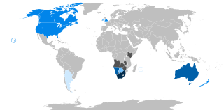
Namibia, officially the Republic of Namibia, is a country in Southern Africa. Its western border is the Atlantic Ocean. It shares land borders with Zambia and Angola to the north, Botswana to the east and South Africa to the south and east. Although it does not border Zimbabwe, less than 200 metres of the Botswanan right bank of the Zambezi River separates the two countries. Namibia gained independence from South Africa on 21 March 1990, following the Namibian War of Independence. Its capital and largest city is Windhoek. Namibia is a member state of the United Nations (UN), the Southern African Development Community (SADC), the African Union (AU) and the Commonwealth of Nations.

Pretoria is one of South Africa’s three capital cities, serving as the seat of the executive branch of government, and as the host to all foreign embassies to South Africa. Cape Town is the legislative capital whereas Bloemfontein is the judicial capital.

Sub-Saharan Africa is, geographically, the area of the continent of Africa that lies south of the Sahara. According to the United Nations, it consists of all African countries and territories that are fully or partly south of the Sahara. While the United Nations geoscheme for Africa excludes the Sudan from its definition of sub-Saharan Africa, the African Union's definition includes the Sudan but instead excludes Mauritania.

Eswatini, officially the Kingdom of Eswatini and formerly named Swaziland, is a landlocked country in Southern Africa. It is bordered by Mozambique to its northeast and South Africa to its north, west, south, and southeast. At no more than 200 kilometres (120 mi) north to south and 130 kilometres (81 mi) east to west, Eswatini is one of the smallest countries in Africa; despite this, its climate and topography are diverse, ranging from a cool and mountainous highveld to a hot and dry lowveld.

The Union of South Africa was the historical predecessor to the present-day Republic of South Africa. It came into existence on 31 May 1910 with the unification of the Cape, the Natal, the Transvaal, and the Orange River colonies. It included the territories that were formerly a part of the South African Republic and the Orange Free State.
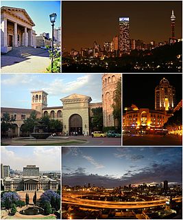
Johannesburg, informally known as Jozi, Joburg, or "The City of Gold", is the largest city in South Africa, classified as a megacity, and is one of the 100 largest urban areas in the world. According to Demographia, the Johannesburg-Pretoria urban area is the 26th-largest in the world, with 14,167,000 inhabitants. It is the provincial capital and largest city of Gauteng, which is the wealthiest province in South Africa. Johannesburg is the seat of the Constitutional Court, the highest court in South Africa. Most of the major South African companies and banks have their head offices in Johannesburg. The city is located in the mineral-rich Witwatersrand range of hills and is the centre of large-scale gold and diamond trade. It was one of the host cities of the official tournament of the 2010 FIFA World Cup – and it hosted the final.

The 2010 FIFA World Cup was the 19th FIFA World Cup, the world championship for men's national association football teams. It took place in South Africa from 11 June to 11 July 2010. The bidding process for hosting the tournament finals was open only to African nations. In 2004, the international football federation, FIFA, selected South Africa over Egypt and Morocco to become the first African nation to host the finals.

Gauteng is one of the nine provinces of South Africa. The name in Sotho-Tswana languages means 'place of gold'.

The South Africa national cricket team, also known as the Proteas, represents South Africa in men's international cricket and is administered by Cricket South Africa. South Africa is a full member of the International Cricket Council (ICC), with Test, One-Day International (ODI) and Twenty20 International (T20I) status. Its nickname derives from South Africa's national flower, Protea cynaroides, commonly known as the "King Protea".

The South Africa national soccer team represents South Africa in men's international soccer and it is run by the South African Football Association, the governing body for Soccer in South Africa. The team's nickname is Bafana Bafana, and South Africa's home ground is FNB Stadium, which is located in Johannesburg. The team's greatest result was winning the Africa Cup of Nations at home in 1996. The team is a member of both FIFA and Confederation of African Football (CAF).
Apartheid was a system of institutionalised racial oppression that existed in South Africa and South West Africa from 1948 until the early 1990s. This system denied non-white South Africans basic human rights, such as the right to vote. Apartheid was characterized by an authoritarian political culture based on baasskap, which ensured that South Africa was dominated politically, socially, and economically by the nation's minority white population. According to this system of social stratification, white citizens had the highest status, followed by Indians and Coloureds, then Africans. The economic legacy and social effects of apartheid continue to the present day.
White South Africans generally refers to South Africans of European descent. In linguistic, cultural, and historical terms, they are generally divided into the Afrikaans-speaking descendants of the Dutch East India Company's original settlers, known as Afrikaners, and the Anglophone descendants of predominantly British people who were colonists of South Africa. In 2016, 57.9% were native Afrikaans speakers, 40.2% were native English speakers, and 1.9% spoke another language as their mother tongue, such as Portuguese, Greek, or German. White South Africans are by far the largest population of White people in Africa. White was a legally defined racial classification during apartheid.

Africa is the world's second-largest and second-most populous continent, after Asia in both cases. At about 30.3 million km2 including adjacent islands, it covers 6% of Earth's total surface area and 20% of its land area. With 1.3 billion people as of 2018, it accounts for about 16% of the world's human population. Africa's population is the youngest amongst all the continents; the median age in 2012 was 19.7, when the worldwide median age was 30.4. Despite a wide range of natural resources, Africa is the least wealthy continent per capita, in part due to geographic impediments, legacies of European colonization in Africa and the Cold War, predatory/neo-colonialistic activities by Western nations and China, and undemocratic rule and deleterious policies. Despite this low concentration of wealth, recent economic expansion and the large and young population make Africa an important economic market in the broader global context.

South Africa, officially the Republic of South Africa (RSA), is the southernmost country in Africa. With over 60 million people, the country is the world's 23rd-most populous nation and covers an area of 1,221,037 square kilometres. South Africa has three capital cities, with the executive, judicial and legislative branches of government based in Pretoria, Bloemfontein and Cape Town respectively. The largest city is Johannesburg. About 81% of the population are Black South Africans. The remaining population consists of Africa's largest communities of European, Asian, and Multiracial ancestry.

Nelson Rolihlahla Mandela was a South African anti-apartheid revolutionary and political leader who served as the first president of South Africa from 1994 to 1999. He was the country's first black head of state and the first elected in a fully representative democratic election. His government focused on dismantling the legacy of apartheid by tackling institutionalised racism and fostering racial reconciliation. Ideologically an African nationalist and socialist, he served as the president of the African National Congress (ANC) party from 1991 to 1997.
Malamulele can refer to the town of Malamulele or the area of Malamulele. Both the town and area are in the Limpopo province of South Africa and predominantly occupied by Tsonga people. Malamulele town has one provincial road and one regional road; the R81 to Giyani and the R524 to Thohoyandou respectively. Malamulele is flanked by two rivers, Levubu River (Rivhubye) to the west and Letaba River to the east, meanwhile the Shingwedzi River runs from Malamulele West to Malamulele East, joining the Olifants in Mozambique on its way to the Indian Ocean. Malamulele is the seat of the Collins Chabane Local Municipality.
Noria Muelwa Mabasa is a Venda artist, who works primarily in ceramic and wood sculpture.


