
Limpopo is the northernmost province of South Africa. It is named after the Limpopo River, which forms the province's western and northern borders. The term Limpopo is derived from Rivombo (Livombo/Lebombo), a group of Tsonga settlers led by Hosi Rivombo who settled in the mountainous vicinity and named the area after their leader. The Lebombo mountains are also named after them. The river has been called the Vhembe by local Venda communities of the area. The capital and largest city in the province is Polokwane, while the provincial legislature is situated in Lebowakgomo.

Tsonga or, natively, Xitsonga, as an endonym, is a Bantu language spoken by the Tsonga people of South Africa. It is mutually intelligible with Tswa and Ronga and the name "Tsonga" is often used as a cover term for all three, also sometimes referred to as Tswa-Ronga. The Xitsonga language has been standardised for both academic and home use. Tsonga is an official language of the Republic of South Africa, and under the name "Shangani" it is recognised as an official language in the Constitution of Zimbabwe. All Tswa-Ronga languages are recognised in Mozambique. It is not official in Eswatini.
Sclerocarya birrea, commonly known as the marula, is a medium-sized deciduous fruit-bearing tree, indigenous to the miombo woodlands of Southern Africa, the Sudano-Sahelian range of West Africa, the savanna woodlands of East Africa and Madagascar.
The Tsonga people are a Bantu ethnic group primarily native to Southern Mozambique and South Africa. They speak Xitsonga, a Southern Bantu language. A very small number of Tsonga people are also found in Zimbabwe and Northern Eswatini. The Tsonga people of South Africa share some history with the Tsonga people of Southern Mozambique, and have similar cultural practices, but differ in the dialects spoken.

South African cuisine reflects the diverse range of culinary traditions embodied by the various communities that inhabit the country. Among the indigenous peoples of South Africa, the Khoisan foraged over 300 species of edible food plants, such as the rooibos shrub legume, whose culinary value continues to exert a salient influence on South African cuisine. Subsequent encounters with Bantu pastoralists facilitated the emergence of cultivated crops and domestic cattle, which supplemented traditional Khoisan techniques of meat preservation. In addition, Bantu-speaking communities forged an extensive repertoire of culinary ingredients and dishes, many of which are still consumed today in traditional settlements and urban entrepôts alike.
The Ndau are an ethnic group. The name "Ndau" means Land. Just like the Manyika people in northern Manicaland, their name Manyika also meaning "Owners of the Land", the name Ndau means Land. E.g "Ndau yedu" meaning "our land" When the Ngoni observed this, they called them the Ndau people, the name itself meaning the land, the place or the country in their language. A traditional outsider suggestion is that the name is derived from the Nguni words "Amading'indawo" which means "those looking for a place" as this is what the Gaza Nguni called them and the name then evolved to Ndau. However, they are described in detail to have already been occupying parts of Zimbabwe and Mozambique in 1500s by the Portuguese missionary Joao dos Santos. The five largest Ndau groups are the Magova; the Mashanga; the Vatomboti, the Madanda and the Teve. Ancient Ndau People met with the Khoi/San during the first trade with the Arabs at Mapungumbwe and its attributed to the Kalanga, Venda, Shona, and Ndau peoples. They traded with Arabs with "Mpalu", "Njeti" and "Vukotlo" these are the red, white and blue coloured cloths together with golden beads. Ndau people traded traditional herbs, spiritual powers, animal skins and bones.

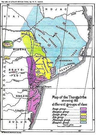
Gazankulu was a bantustan in South Africa, intended by the apartheid government to be a semi-independent homeland for the Tsonga people. It was located in both the Northern Transvaal, now Limpopo province and Eastern Transvaal, now Mpumalanga province.
Johannesburg North is a suburb of Randburg, South Africa. It is located in Region C of the City of Johannesburg Metropolitan Municipality.
Giyani is a city situated in the north-eastern part of Limpopo Province, South Africa. It is the administrative capital of the Mopani District Municipality and a former capital of the defunct Gazankulu Bantustan. The city of Giyani is divided into seven sections: Section A, Section D1, Section D2, Section E, Section F, Kremetart, and Giyani CBD. Risinga View and Church View are new residential areas in Giyani, but they fall under the local traditional leaders. The Giyani CBD is nicknamed Benstore, and this name is commonly used by residents of the region. Giyani is surrounded by a number of villages with rich Tsonga cultural activities, administered by the Greater Giyani Local Municipality.

The cuisine of Botswana is unique but shares some characteristics with other cuisines of Southern Africa. Examples of Setswana food include pap, samp, magwinya, bogobe and mophane worms. A food unique to Botswana is seswaa, salted mashed-up meat.

Diospyros mespiliformis, the jackalberry, is a large dioecious evergreen tree found mostly in the savannas of Africa. Jackals are fond of the fruit, hence the common names. It is a member of the family Ebenaceae, and is related to the true ebony and edible persimmon.

The Vhembe District Municipality is one of the 5 districts of the Limpopo province of South Africa. It is the northernmost district of the country and shares its northern border with the Beitbridge District in Zimbabwe and on the east with the Gaza Province in Mozambique. Vhembe consists of all the territories that were part of the former Venda Bantustan; however, two large densely populated districts of the former Tsonga homeland of Gazankulu, in particular, Hlanganani and Malamulele, were also incorporated into the municipality, hence the ethnic diversity of the district. The seat is Thohoyandou, the capital of the former Venda Bantustan. According to the 2011 census, the majority of the municipality's 800,000 inhabitants spoke TshiVenda as their mother language, while 400,000 spoke Xitsonga as their home language. However, the Tsonga people form the majority south of the Levubu River, while the Venda are the minority south of Levubu at 15%. The Sepedi speakers number 27,000. The district code is DC34.
The Chopi are a Bantu ethnic group of Mozambique. They have lived primarily in the Zavala region of southern Mozambique, in the Inhambane Province. They traditionally lived a life of subsistence agriculture, traditionally living a rural existence, although many were displaced or killed in the civil war that followed Mozambique's liberation from Portuguese colonial rule in 1975. In addition, drought forced many away from their homeland and into the nation's cities.
Mahwelereng is a township in the Mogalakwena Local Municipality of the Waterberg District Municipality of the Limpopo Province of South Africa, It is about 2 km from Mokopane. The township is a product of Apartheid South Africa's policies in the former Bantustan of Lebowa. Most of the original residents of Mahwelereng were from an area which old residents call "Ol' Location". Ol' Location was too close to town and the residents had to be moved further away from town. There are still remnants of Ol' Location such as the "Bar" and the Lutheran Church Mission on the Sekgakgapeng site. The township is bordered by Sekgakgapeng, Mountainview, Moshate, Phola Park, and Ga-Madiba.
Oyo Igboho is a large town in Oyo State, Nigeria. It is the headquarters of the Orelope Local Government Area. It has an estimated population of 200,000.
Waterval is a residential township in front of Elim Hospital, it is situated in the Hlanganani district of the former Tsonga homeland of Gazankulu, alongside the R578 road to Giyani in the Limpopo province of South Africa. Waterval includes Njhakanjhaka, Lemana, Elim Hospital, Elim Mall, Hubyeni Shopping centre, Magangeni but excludes Shirley village, which is a separate and stand alone farm, sharing a legal boundary with Waterval and Mbhokota village to the east.
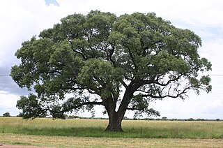
Namakgale is a large township lying 12 km outside Phalaborwa in Mopani District in the Limpopo province of South Africa. Its nearest neighbouring townships are Lulekani, Makhushane, Maseke and Mashishimale on the R71 road to Gravelotte (GaMaenetje). It is next to the Kruger National Park on the north eastern part of the Limpopo province previously Northern Transvaal. The township enjoys the annual Marula festival during the months of February and March, when the ripe Marula fruit harvest is at its peak, and the Marula traditional beer is brewed. This is home to the Amarula liqueur is harvested, and the pulp is shipped to Cape Town for further processing. The citizens of Namakgale will enjoy the Mopani worms first harvest during March and April, and the second harvest in December. the Mopani tree and the Morula tree are very important to the residents of the Namakgale as they bring important community subsistence farming.
Tiyani is a village situated on the banks of the Middle Letaba Dam in the Hlanganani District of the former Gazankulu homeland, which currently form part of the Vhembe District Municipality in the Limpopo province of South Africa.
Valdezia is a sprawling rural settlement situated at the foothills of the Soutpansberg mountain range in Louis Trichardt, Limpopo Province, South Africa. It was formerly known as Albasini before Swiss Missionaries renamed it Valdezia in 1875. The village itself was formally established in 1820 by Tsonga refugees who were fleeing despotic rule from Soshangane. It is roughly 10 km east of Elim Hospital in the Hlanganani district in the former Gazankulu homeland, South Africa. It was the site of a Swiss mission station, and it was named after the Swiss canton of Vaud. Valdezia's population, according to the official census of 2011, currently stands at between 7,600 and 8,000 people. It is considered the birthplace of the written Tsonga language in South Africa.
Acornhoek, commonly known as Khenhuk, is a semi-rural town situated in the north eastern areas of Bushbuckridge in the Mpumalanga province of South Africa.


