Burnaugh, Kentucky | |
---|---|
Nickname: Big Town of Burnaugh | |
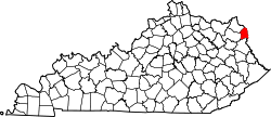
Coordinates: 38°15′37″N82°34′54″W / 38.26028°N 82.58167°W | |
Country | United States |
State | Kentucky |
County | Boyd |
Elevation | 587 ft (179 m) |
Time zone | UTC-5 (Eastern (EST)) |
• Summer (DST) | UTC-4 (EDT) |
ZIP code | 41129 |
GNIS feature ID | 488442 [1] |
Burnaugh, Kentucky is an unincorporated community located in Boyd County, Kentucky along U.S. Route 23. Being located between the Burgess Station, a former C&O Freight and passenger terminal and Kavanaugh, it takes its name from the combination of the two communities. [2] It is located on both the former Mayo Trail (Ky. Rt. 3 prior to 1964) and present-day U.S. Route 23. Burnaugh is located within the ZIP Code Tabulation Area for zip code 41129, which includes the nearby city of Catlettsburg. [3]
Special Metals Corporation has operated a facility at Burnaugh since 1967. [4]
A ZIP Code is a system of postal codes used by the United States Postal Service (USPS). Introduced on July 1, 1963, the basic format consisted of five digits. In 1983, an extended ZIP+4 code was introduced; it included the five digits of the ZIP Code, followed by a hyphen and four digits that designated a more specific location.
David is an unincorporated community and coal town in Floyd County, Kentucky, United States along County Route 404. Located in the Appalachian Mountains, it lies approximately 100 miles (160 km) southeast of Lexington. The town was named for David L. Francis, president of Princess Elkhorn Coal Company which originally built and owned the town. It bears the postal ZIP code 41616. The U.S. Census of 2000 recorded a population of 435.
Elizaville is a census-designated place and unincorporated community in Fleming County, Kentucky, United States. Its population was 181 as of the 2010 census. Elizaville is located at the junction of Kentucky Route 32 and Kentucky Route 170, 5 miles (8.0 km) west of Flemingsburg. Elizaville has a post office with ZIP code 41037.
Buffalo is an unincorporated community and census-designated place (CDP) in southern LaRue County, Kentucky, United States. Its population was 498 as of the 2010 census. It lies along Kentucky Route 61 south of the city of Hodgenville, the county seat of LaRue County. Its elevation is 748 feet (228 m), and it is located at 37°30′43″N85°41′55″W. Although Buffalo is unincorporated, it has a post office, with the ZIP code of 42716.
Sitka is an unincorporated community with U.S. Post Office centered on KY Route 201, in Johnson County, Kentucky, United States. It is located at an elevation of 712 feet. Sitka's ZIP code is 41255.
Alloy is an unincorporated community in Fayette County, West Virginia, United States. Alloy is located along the Kanawha River and U.S. Route 60, 5 miles (8.0 km) southwest of Gauley Bridge. Alloy was originally known as Boncar until the mid-1930s. Both the original placename and the current placename refer to the ferroalloy plant that still operates here. The metals plant was originally the Electro Metallurgical Co.; a unit of Union Carbide and Carbon Corporation. Alloy has a post office with ZIP code 25002.
Maceo is an unincorporated community and census-designated place (CDP) in Daviess County, Kentucky, United States. As of the 2010 census, it had a population of 413.
Kavanaugh, Kentucky is an unincorporated community located in Boyd County, Kentucky, located along U.S. Route 23 directly north of the Lawrence County line. In 1984, the original alignment of U.S. 23 was replaced with a modern four-lane highway. CSX Transportation's Big Sandy Subdivision railroad tracks pass through the community. The railroad was formerly operated by the Chessie System and its predecessor the Chesapeake and Ohio Railway Company.
Lockwood is an unincorporated community located along U.S. Route 23 and the Big Sandy River in southern Boyd County, Kentucky, United States, approximately 7 mi south of Catlettsburg, the county seat.
Durbin, Kentucky is an unincorporated community situated along Kentucky Route 752 and Durbin Creek in southern Boyd County, Kentucky. The post office was established on March 5, 1900, with Robert Struther as postmaster, and was named for Amos Durbin, an early explorer. It is located within the ZIP Code Tabulation Area for zip code 41129, which includes the city of Catlettsburg.
Fisty is an unincorporated community in Knott County, Kentucky, United States. Fisty is located at the junction of Kentucky Route 550 and Kentucky Route 721 6.5 miles (10.5 km) west of Hindman. Fisty has a post office with ZIP code 41743.
Betsy Layne is a census-designated place (CDP) and coal town in Floyd County, Kentucky, United States. It was established in 1875 along the Levisa Fork. The post office opened on May 1, 1908, with Clayton S. Hitchins as postmaster. Its ZIP code is 41605. The 2010 census reported the population to be 688. Stage actress Bette Henritze was a native of Betsy Layne.
Stopover is an unincorporated community in Pike County, Kentucky, United States that was established on August 14, 1949. It is at the junction of Kentucky Route 194 and Kentucky Route 2062 3.5 miles (5.6 km) east of Phelps. Stopover had a post office with ZIP code 41568.
Hueysville, also known as Bosco, is an unincorporated community in Floyd County, Kentucky, United States. It has a post office with a ZIP Code of 41640. Hueysville is located on Salt Lick Creek Road west of Kentucky Route 550. CSX Transportation's E&BV Subdivision passes through Hueysville.
Belcher is an unincorporated community in Pike County, Kentucky. Belcher is located at the junction of U.S. Route 460 and Kentucky Route 80 2.9 miles (4.7 km) north-northwest of Elkhorn City. Belcher has a post office with ZIP code 41513.
Arjay is an unincorporated community and coal town in Bell County, Kentucky, United States. Arjay is located on Kentucky Route 66 4 miles (6.4 km) northeast of Pineville. Arjay has a post office with ZIP code 40902, which opened on February 23, 1911. The community's name comes from the initials of coal operator R. J. Asher.
Aberdeen is an unincorporated community and coal town located in Butler County, Kentucky, United States.
Garrison is an unincorporated community and census-designated place in Lewis County, Kentucky, United States. Its population was 866 as of the 2010 census. Garrison has a post office with ZIP code 41141, which opened on February 26, 1886. The community is located along the Ohio River and Kentucky Route 8.
Lejunior is an unincorporated community in Harlan County, Kentucky, United States. The community is located along Kentucky Route 38 and the Cumberland River 4.3 miles (6.9 km) northeast of Evarts. Lejunior has a post office with ZIP code 40849.
Dema is an unincorporated community in Floyd and Knott counties in the U.S. state of Kentucky. The community is located on Kentucky Route 7 1.7 miles (2.7 km) south of Wayland. Dema has a post office with ZIP code 41845.