
Newport is an unincorporated community in Monroe County in the U.S. state of Michigan. The community is located within Berlin Charter Township. As an unincorporated community, Newport has no legally defined boundaries or population statistics of its own but does have its own post office with the 48166 ZIP Code.

Briceville is an unincorporated community in Anderson County, Tennessee. It is included in the Knoxville, Tennessee Metropolitan Statistical Area. The community is named for railroad tycoon and one-term Democratic U.S. Senator Calvin S. Brice of Ohio, who was instrumental in bringing railroad service to the town.

Bunker Hill is an unincorporated community in Berkeley County, West Virginia, United States, located in the lower Shenandoah Valley on Winchester Pike at its junction with County Route 26 south of Martinsburg. It is the site of the confluence of Torytown Run and Mill Creek, a tributary of Opequon Creek which flows into Winchester, Virginia. According to the 2000 census, the Bunker Hill community has a population of 5,319.
Princess is a small unincorporated community in Boyd County, Kentucky, United States.

Gregory is an unincorporated community in Livingston County in the U.S. state of Michigan. The community is located within Unadilla Township. As an unincorporated community, Gregory has no legally defined boundaries or population statistics of its own but does have its own post office with the 48137 ZIP Code.
Parksville is a small unincorporated community on the Chaplin River in south central Boyle County, Kentucky, United States. It is located at the eastern end of Ky Route 300, where it intersects with Ky Route 34, near the US Post Office. The global position of Parksville is 37.597N latitude and -84.891W longitude. Elevation is 1,083 feet (330 m) above sea level. Current population is approximately 900 people. The ZIP Code for Parksville is 40464.

Ida is an unincorporated community and census-designated place (CDP) in Monroe County in the U.S. state of Michigan. The CDP had a population of 790 at the 2020 census. The community is mostly within Ida Township with a smaller portion extending north into Raisinville Township.

Boyd County is a county located in the U.S. Commonwealth of Kentucky. As of the 2020 census, its population was 48,261. The county seat is Catlettsburg, and its largest city is Ashland. The county was formed in 1860. The county spans 160 square miles (410 km2), and is found at the northeastern edge of the state, near the Ohio River and Big Sandy River and situated in mountainous Appalachia. Boyd County is in the Huntington-Ashland, WV-KY-OH metropolitan statistical area.

Roaring Gap is an unincorporated community in the Cherry Lane Township of Alleghany County, North Carolina, United States, situated near the border with Wilkes County. Home to three private golf communities, Roaring Gap is a popular summer colony.

Elmira is an unincorporated community in the U.S. state of Michigan. Located along M-32, the community is on the county line between Warner Township in Antrim County to the west and Elmira Township in Otsego County to the east.
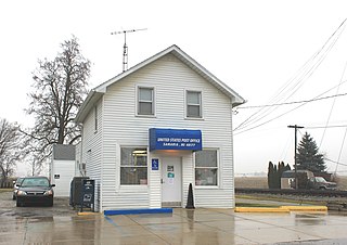
Samaria is an unincorporated community in Monroe County in the U.S. state of Michigan. The community is located within Bedford Township. As an unincorporated community, Samaria has no legally defined boundaries or population statistics of its own but does have its own post office with the 48177 ZIP Code.
Rush Run is an unincorporated community in Warren Township, Jefferson County, Ohio, United States. It is mainly around the area of Rush Run Road also known as County Road 17. It is named for David Rush who settled in that area in 1798.
Burnaugh, Kentucky is an unincorporated community located in Boyd County, Kentucky along U.S. Route 23. Being located between the Burgess Station, a former C&O Freight and passenger terminal and Kavanaugh, it takes its name from the combination of the two communities. It is located on both the former Mayo Trail and present-day U.S. Route 23. Burnaugh is located within the ZIP Code Tabulation Area for zip code 41129, which includes the nearby city of Catlettsburg.
Lockwood is an unincorporated community located along U.S. Route 23 and the Big Sandy River in southern Boyd County, Kentucky, United States, approximately 7 mi south of Catlettsburg, the county seat.

Arthur is an unincorporated community in Claiborne County, Tennessee, United States. It is located along State Route 63 southwest of Harrogate, and a few miles south of the Cumberland Gap. Its zip code is 37707.
Culberson is an unincorporated community in Cherokee County, North Carolina, United States. Culberson is located on North Carolina Highway 60 near the Georgia state line, 10 miles (16 km) southwest of Murphy. Culberson has a post office with ZIP code 28903. Culberson is also home to a store, a few churches, a flea market, a local winery, several family-owned businesses, and a gas station on the NC/GA state line.
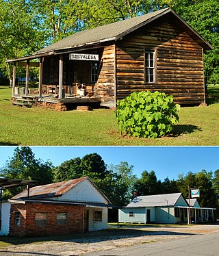
Louvale is an unincorporated community in Stewart County, Georgia, United States. The community is located along U.S. Route 27, 8.7 miles (14.0 km) north of Lumpkin. Louvale has a post office with ZIP code 31814.

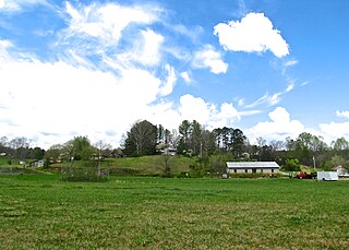
Chambersburg Township is a township in Iredell County, North Carolina, United States. The 2010 United States Census reported a total population of 11,344.
Mooreville is an unincorporated community in Washtenaw County in the U.S. state of Michigan. The community is located within York Township. As an unincorporated community, Mooreville has no legally defined boundaries or population statistics of its own.
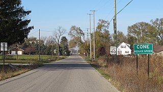
Cone is an unincorporated community in Monroe County in the U.S. state of Michigan. The community is located within Milan Township. As an unincorporated community, Cone has no legally defined boundaries or population statistics of its own.


