Normal, Kentucky

Last updated

Normal
USA Kentucky location map.svg
Red pog.svg
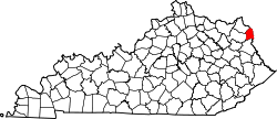
Normal
Location within the state of Kentucky
Usa edcp location map.svg
Red pog.svg
Normal
Normal (the United States)
Coordinates: 38°26′37″N82°36′45″W / 38.44361°N 82.61250°W / 38.44361; -82.61250
Country United States
State Kentucky
County Boyd
Elevation
564 ft (172 m)
Time zone UTC-5 (Eastern (EST))
  Summer (DST) UTC-4 (EST)
GNIS feature ID499521 [1]

Normal is a residential unincorporated community, located within the city of Ashland, Kentucky along U.S. Route 23 and U.S. Route 60 and the Ohio River. It was annexed by the City of Ashland in 1905. Previously, Normal was an independent community with post office. Normal Presbyterian Church, founded in 1890, is one of the last surviving remnants of the original community of Normal. The originally wooden church was razed in 1957 when the current brick structure was completed across 44th Street.

Normal was named after the Eastern Kentucky Normal School, a teachers school that was opened here in 1867, by Mrs Mordecai Williams, wife of the original landowner of the community. Mordecai Williams was an Iron master who owned 600 acres of land of the present day area of Normal, from Cliffside Branch to Haney Branch at the Catlettsburg city limits. His stately residence is still standing at Normal, a brick mansion of Colonial style, located on U.S. Routes 23 and 60 at the Catlettsburg-Ashland City Limits. Williams wife operated the Normal School from the home from 1878 to 1889. It is one of the oldest homes in the entire area and has long served as landmark to the community.

Most residential zones in this section of the city have been transferred to commercial and industrial zones. Cintas Corporation operates a large facility in the former Washington Avenue section located east of the CSX railroad tracks. The community originally grew up around the coke plant built and operated by Semet Solvay and later owned by Armco/AK steel. The Normal coke plant was in operation from 1891 until it was finally closed due to its inability to comply with U.S. Environmental Protection Agency regulations in July 2011. The only concentrations of residential dwellings remaining in Normal are along Blackburn Avenue (also known as 45th Street), Daniels Street, and from Chestnut Avenue south to the Catlettsburg city limits, which is also known as Williams Addition.

Related Research Articles

<span class="mw-page-title-main">Ashland, Kentucky</span> City in Kentucky, United States

Ashland is a home rule-class city in Boyd County, Kentucky, United States. The largest city in Boyd County, Ashland is located upon a southern bank of the Ohio River at the state border with Ohio and near West Virginia. The population was 21,625 at the 2020 census. Ashland is a principal city of the Huntington–Ashland metropolitan area, referred to locally as the "Tri-State area", home to 359,862 residents as of 2020. Ashland serves as an important economic and medical center for northeastern Kentucky.

<span class="mw-page-title-main">Catlettsburg, Kentucky</span> City in Kentucky, United States

Catlettsburg is a home rule-class city in and the county seat of Boyd County, Kentucky, United States. The city population was 1,780 at the 2020 census. It is part of the Huntington–Ashland metropolitan area.

<span class="mw-page-title-main">Grayson, Kentucky</span> City in Kentucky, United States

Grayson is a home rule-class city in and the county seat of Carter County, Kentucky, United States, on US Route 60 and Interstate 64 in the state's northeastern region. It is approximately 21 miles west of Ashland. Within the city limits, the population was 4,217 at the 2010 census. Along with Carter County, the city is closely associated with the nearby Huntington-Ashland, WV-KY-OH Metropolitan Statistical Area and is often erroneously included in the MSA being just 9 miles west of the M.S.A's western boundary.

<span class="mw-page-title-main">Bellefonte, Kentucky</span> City in Kentucky, United States

Bellefonte is a home rule-class city in Greenup County, Kentucky, United States. The population was 888 at the 2010 census. Bellefonte is a part of the Huntington-Ashland, WV-KY-OH Metropolitan Statistical Area (MSA). In 2013, according to new boundary definitions, the MSA had a population of 361,580.

<span class="mw-page-title-main">Flatwoods, Kentucky</span> City in Kentucky, United States

Flatwoods is a home rule-class city in Greenup County, Kentucky, United States. The population was 7,325 at the 2020 census, making it the largest city in Greenup County. Flatwoods is a part of the Huntington–Ashland metropolitan area. Locally, Flatwoods is considered to be a bedroom community, as it has no large employer within the city. Many residents work for CSX Transportation, Marathon Petroleum, or King's Daughters Medical Center.

<span class="mw-page-title-main">Green Line (CTA)</span> Rapid transit line, part of the Chicago L system

The Green Line is a rapid transit line on the Chicago Transit Authority's "L" system. It is the only completely elevated route in the "L" system. All other routes may have various combinations of elevated, subway, street level, or freeway median sections.

<span class="mw-page-title-main">U.S. Route 23</span> Highway in the United States

U.S. Route 23 or U.S. Highway 23 is a major north–south U.S. Highway between Jacksonville, Florida, and Mackinaw City, Michigan. It is an original 1926 route which originally reached only as far south as Portsmouth, Ohio, and has since been extended. It was formerly part of the major highway known as the Dixie Highway. The highway's southern terminus is in Jacksonville, Florida at US 1/US 17. The northern terminus is at I-75 in Mackinaw City, Michigan.

Cannonsburg is a census-designated place (CDP) in Boyd County, Kentucky, United States. As of the 2010 census, it had a population of 856. Cannonsburg is located 8 miles (13 km) southwest of the city of Ashland, a major urban center in northeastern Kentucky. Most of Cannonsburg shares its ZIP code with Ashland; however, parts are within the Catlettsburg ZIP code. The Cannonsburg post office closed in 1929. Cannonsburg is a part of the Huntington-Ashland Metropolitan Statistical Area (MSA). As of the 2010 census, the MSA had a population of 287,702. New definitions from February 28, 2013 placed the population at 363,000.

<span class="mw-page-title-main">Coalton, Kentucky</span> Unincorporated community in Kentucky, United States

Coalton is an unincorporated community situated along U.S. Route 60, which was formerly known as the Midland Trail in western Boyd County, Kentucky, United States. U.S. Route 60 between Rush and Cannonsburg. Coalton is a part of the Huntington-Ashland Metropolitan Statistical Area (MSA). As of the 2010 census, the MSA had a population of 287,702. New definitions from February 28, 2013, placed the population at 361,500. Coalton is located within both the Ashland and Rush postal zip codes.

<span class="mw-page-title-main">U.S. Route 60 in Kentucky</span> Highway in Kentucky

U.S. Route 60 (US 60) is a major U.S. Highway in the American state of Kentucky. In the early days of the U.S. Highway System, US 60 was originally to be numbered as US 62. Following extensive lobbying and complaints filed by Kentucky governor William J. Fields to the American Association of State Highway Officials, the route was re-designated as US 60 before the system was finalized. In Kentucky, US 60 parallels the Ohio River. US 60 enters Kentucky from Cairo, Illinois, traveling northeast to Louisville, then takes a direct eastward route to rejoin the Ohio River in downtown Ashland, Kentucky. Both US 60 and US 23 run concurrently from Ashland to Catlettsburg where US 60 turns east and enters Kenova, West Virginia. US 60 is the longest route in Kentucky, running 495 miles (797 km) across the width of the state, passing through 22 of Kentucky's counties and through the cities of Paducah, Henderson, Owensboro, Louisville, the state capital of Frankfort, and Lexington.

<span class="mw-page-title-main">Ashland Transportation Center</span>

Ashland Transportation Center is an intermodal transit station in Ashland, Kentucky. Jointly operated by the City of Ashland and CSX Transportation, it currently serves Amtrak's Cardinal train as well as the Ashland Bus System and Greyhound Lines buses. It is located at 99 15th Street near downtown Ashland.

<span class="mw-page-title-main">Kentucky Route 168</span>

Kentucky Route 168 is a two-lane route extending from US 23 in Westwood to the US 23/60 multiplex in Catlettsburg. Its southern end point in Catlettsburg was originally at the underpass where Walnut and Louisa Streets once split. In 1971, the former ending was truncated to its present location due to the re-routing of U.S. 23 around downtown Catlettsburg. Once inside the city of Ashland, it traverses three different surface streets known as Valley View Drive, Blackburn Avenue and South Belmont Street via a series of turns, mainly within the South Ashland residential district. In Ashland, it crosses 13th Street at an intersection locally known as Community.

<span class="mw-page-title-main">U.S. Route 23 in Kentucky</span>

U.S. Route 23 (US 23) is a 157.765-mile-long (253.898 km) United States Numbered Highway in the state of Kentucky. It travels from the Virginia state line near Jenkins to the Ohio state line west of South Shore via Jenkins, Pikeville, Coal Run Village, Prestonsburg, Paintsville, Louisa, Catlettsburg, Ashland, Russell, Flatwoods, Raceland, Wurtland, Greenup, and South Shore.

<span class="mw-page-title-main">Boyd County, Kentucky</span> County in Kentucky, United States

Boyd County is a county located in the U.S. state of Kentucky. As of the 2020 census, its population was 48,261. The county seat is Catlettsburg, and its largest city is Ashland. The county was formed in 1860. Its 160 square miles (410 km2) are found at the northeastern edge of the state near the Ohio River and Big Sandy River, nestled in the verdant rolling hills of Appalachia. Boyd County is in the Huntington-Ashland, WV-KY-OH metropolitan statistical area.

<span class="mw-page-title-main">United States District Court for the Eastern District of Kentucky</span> United States federal district court in Kentucky

The United States District Court for the Eastern District of Kentucky is the Federal district court whose jurisdiction comprises approximately the Eastern half of the Commonwealth of Kentucky. The United States Court of Appeals for the Sixth Circuit in Cincinnati, Ohio maintains appellate jurisdiction for the district.

Ashland is a city in north-eastern Kentucky. Prior to European colonization, it was home to the Adena culture, Hopewell culture, Armstrong culture, and Fort Ancient Native American groups, and later the Shawnee. European settlement by Scots-Irish Americans began in 1783. In 1800, iron deposits were discovered in Ashland, which would lead to an influx of industry over the next two centuries. In the 21st century, city growth has spilled into neighboring areas, technically outside of city-limits, and the industrial economy has shrunk alongside expansions in the services sector.

<span class="mw-page-title-main">Catlettsburg Refinery</span>

The Catlettsburg Refinery is an American oil refinery. It is located in northeastern Kentucky, at the intersection of Interstate 64 and U.S. Route 23 in Catlettsburg, Kentucky near the cities of Ashland, Kentucky and Huntington, West Virginia. The facility was built in 1916 by the Great Eastern Refining Company and purchased in 1924 by the Ashland Refining Company. The refinery now occupies a 650-acre (260 ha) plus site, producing more than 291,000 barrels per day (46,300 m3/d), and employing around 1,600 employees and contractors. Its location on the west banks of the Big Sandy River and only two miles south of the Ohio River, allows it to ship products by barge as well as pipeline. It is owned and operated by Marathon Petroleum Corporation.

<span class="mw-page-title-main">Boynton–Oakwood Heights</span> Neighborhoods of Detroit in Wayne, Michigan, United States

Boynton and Oakwood Heights are the two southernmost neighborhoods of the city of Detroit in the U.S. state of Michigan. The two neighborhoods occupy the only portions of Detroit located south of the River Rouge.

<span class="mw-page-title-main">Catlettsburg station</span>

Catlettsburg is a former Chesapeake and Ohio Railroad station located in downtown Catlettsburg, Kentucky. Opened between 1897 and 1890 to replace an older wooden station, it served trains until 1958. Amtrak trains began stopping at Tri-State Station some 1.5 miles (2.4 km) to the north in 1975; it was renamed Catlettsburg around 1988. Amtrak service was moved from Catlettsburg to Ashland in 1998. The C&O station was refurbished from 2004 to 2006 and added to the National Register of Historic Places in 2012.

References