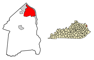
Ashland is a home rule-class city in Boyd County, Kentucky, in the United States. Ashland, the largest city in Boyd County, is located upon a southern bank of the Ohio River. The population was 21,684 at the 2010 census. Ashland is the smaller of two primary cities in the Huntington-Ashland metropolitan area, which is referred to locally as the "Tri-State area" and had a population of 361,487 in 2017, while the Kentucky portion was home to 110,641 in 2017. Ashland serves as an important economic and medical center for northeastern Kentucky and is part of the fifth-largest metropolitan area in Kentucky.

Catlettsburg is a home rule-class city in and the county seat of Boyd County, Kentucky, United States. The city population was 1,856 at the 2010 census. Catlettsburg is a part of the Huntington-Ashland, WV-KY-OH, Metropolitan Statistical Area (MSA). As of 2013, new definitions from the United States Census, the MSA had a population of 361,000.

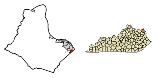
Westwood is a census-designated place (CDP) in Boyd County, Kentucky, United States. The population was 4,746 at the 2010 census. It serves as a suburb of the city of Ashland. Westwood is closely affiliated with Ashland, as it shares its ZIP code and bus system with the city. Westwood is located on a flat to hilly elevation just west of the Ohio River. The flat hilltop is unusual to eastern Kentucky and was created by the preglacial Teays River which existed in ancient times and flowed in the opposite direction of the Ohio River.

Grayson is a home rule-class city in and the county seat of Carter County, Kentucky, United States, on US Route 60 and Interstate 64 in the state's northeastern region. It is approximately 21 miles west of Ashland. Within the city limits, the population was 4,217 at the 2010 census. Along with Carter County, the city is closely associated with the nearby Huntington-Ashland, WV-KY-OH Metropolitan Statistical Area and is often erroneously included in the MSA being just 9 miles west of the M.S.A's western boundary.
Bellefonte is a home rule-class city in Greenup County, Kentucky, United States. The population was 888 at the 2010 census. Bellefonte is a part of the Huntington-Ashland, WV-KY-OH Metropolitan Statistical Area (MSA). In 2013, according to new boundary definitions, the MSA had a population of 361,580.

Flatwoods is a home rule-class city in Greenup County, Kentucky, United States. Flatwoods is considered a suburb of nearby Ashland, although Ashland itself is located in neighboring Boyd County. The population of Flatwoods was 7,423 at the 2010 census, making Flatwoods the largest city in Greenup County. Flatwoods is a part of the Huntington-Ashland, WV-KY-OH, Metropolitan Statistical Area (MSA). As of the 2010 census, the MSA had a population of 287,702.

Greenup is a home rule-class city located at the confluence of the Little Sandy River with the Ohio River in Greenup County, Kentucky, United States. The population was 1,188 at the 2010 census. Greenup is one of three county seats in the Commonwealth of Kentucky to share its name with its county; the other two being Harlan and Henderson.

Wurtland is a home rule-class city in Greenup County, Kentucky, United States, along the Ohio River. The population was 995 at the 2010 census. Wurtland is a part of the Huntington-Ashland, WV-KY-OH, Metropolitan Statistical Area (MSA). As of the 2010 census, the MSA had a population of 287,702.
Cannonsburg is a census-designated place (CDP) in Boyd County, Kentucky, United States. As of the 2010 census, it had a population of 856. Cannonsburg is located 8 miles (13 km) southwest of the city of Ashland, a major urban center in northeastern Kentucky. Most of Cannonsburg shares its ZIP code with Ashland; however, parts are within the Catlettsburg ZIP code. The Cannonsburg post office closed in 1929. Cannonsburg is a part of the Huntington-Ashland Metropolitan Statistical Area (MSA). As of the 2010 census, the MSA had a population of 287,702. New definitions from February 28, 2013 placed the population at 363,000.
EastPark is a 1000-acre (4 km2) industrial park located in the state of Kentucky, United States, at the junction of Boyd, Greenup, and Carter counties, although most of the park resides in Greenup County. The park is operated by the Northeast Kentucky Regional Industrial Park Authority. The site of the park was donated to the state of Kentucky by Addington Enterprises from reclaimed land that had once been used as a strip mine. The state of Kentucky used the donated land to build the park and a two-lane highway, now known as the Industrial Parkway This proved to be beneficial to both Addington and the state, as the land was not able to be developed without the road and it provided a way to connect US 23 in Greenup County to Interstate 64. The park has a convenient location, as it is located where Interstate 64 and KY 67 intersect. EastPark is also connected to a port on the Ohio River in Wurtland, Kentucky, via KY 67.

Rush is an unincorporated community in Boyd and Carter counties in the U.S. state of Kentucky. As of the 2000 census, the community had a total population of 2,755 within its postal zip code.
Summit is an unincorporated community in Boyd County, Kentucky, United States on US 60 just west of Ashland. Summit serves as a suburb to the city of Ashland and shares the city's ZIP code. Summit is sometimes spelled with two "T's" at the end, although the most common spelling contains only one "T" but either variation is accepted as correct.
Meads is an unincorporated community in Boyd County, Kentucky, United States. It is located along the U.S. Highway 60 corridor south of Ashland.
Princess is a small unincorporated community in Boyd County, Kentucky, United States.
Coalton is an unincorporated community situated along U.S. Route 60, which was formerly known as the Midland Trail in western Boyd County, Kentucky, United States. U.S. Route 60 between Rush and Cannonsburg. Coalton is a part of the Huntington-Ashland Metropolitan Statistical Area (MSA). As of the 2010 census, the MSA had a population of 287,702. New definitions from February 28, 2013, placed the population at 361,500. Coalton is located within both the Ashland and Rush postal zip codes.

The Charleston Metropolitan Statistical Area, as defined by the United States Census Bureau, is an area consisting of three counties in West Virginia, anchored by the city of Charleston. It is the largest metropolitan area entirely within the state of West Virginia. While the Huntington Metro Area is more populous, it spans three states, and the core county of the Charleston area, Kanawha County, is more populous than the West Virginia portion of the Huntington area.
Ironville is an unincorporated community in Boyd County, Kentucky, United States, near the intersection of Kentucky Route 5 and Kentucky Route 766. Due to its proximity to Ashland, Ironville is often considered to be a part of Ashland, although officially it is separate from the city and serves as a suburb to the city. It shares its ZIP code with Ashland as well.
The Huntington–Ashland metropolitan area is a metropolitan area in the Appalachian Plateau region of the United States. Referred to locally as the “Tri-State area”, the region spans seven counties in the three states of West Virginia, Kentucky, and Ohio. With a population of 361,580, the Tri-State area is nestled along the banks of the Ohio River. The region offers a diverse range of outdoor activities.

Boyd County is a county located in the U.S. state of Kentucky. As of the 2010 census, the population was 49,542. The county seat is Catlettsburg, and its largest city is Ashland. The county was formed in 1860. Its 160 square miles (410 km2) are found at the northeastern edge of the state near the Ohio River and Big Sandy River, nestled in the verdant rolling hills of Appalachia.

Metro Cincinnati is a metropolitan area centered on Cincinnati and including surrounding counties in the U.S. states of Ohio, Kentucky, and Indiana. The area is commonly known as Greater Cincinnati.


