Durbin, Kentucky

Last updated
Durbin, Kentucky
Unincorporated community
USA Kentucky location map.svg
Red pog.svg
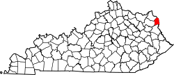
Durbin, Kentucky
Location within the state of Kentucky
Usa edcp location map.svg
Red pog.svg
Durbin, Kentucky
Durbin, Kentucky (the US)
Coordinates: 38°16′45″N82°35′54″W / 38.27917°N 82.59833°W / 38.27917; -82.59833 Coordinates: 38°16′45″N82°35′54″W / 38.27917°N 82.59833°W / 38.27917; -82.59833
Country United States
State Kentucky
County Boyd
Elevation 551 ft (168 m)
Time zone Eastern (EST) (UTC-5)
  Summer (DST) EDT (UTC-4)
ZIP code 41129
GNIS feature ID 507893 [1]

Durbin, Kentucky is an unincorporated community situated along Kentucky Route 752 and Durbin Creek in southern Boyd County, Kentucky. The post office was established on March 5, 1900, with Robert Struther as postmaster, and was named for Amos Durbin, an early explorer. [2] It is located within the ZIP Code Tabulation Area for zip code 41129, which includes the city of Catlettsburg. [3]

Unincorporated area Region of land not governed by own local government

In law, an unincorporated area is a region of land that is not governed by a local municipal corporation; similarly an unincorporated community is a settlement that is not governed by its own local municipal corporation, but rather is administered as part of larger administrative divisions, such as a township, parish, borough, county, city, canton, state, province or country. Occasionally, municipalities dissolve or disincorporate, which may happen if they become fiscally insolvent, and services become the responsibility of a higher administration. Widespread unincorporated communities and areas are a distinguishing feature of the United States and Canada. In most other countries of the world, there are either no unincorporated areas at all, or these are very rare; typically remote, outlying, sparsely populated or uninhabited areas.

Boyd County, Kentucky County in the United States

Boyd County is a county located in the U.S. state of Kentucky. As of the 2010 census, the population was 49,542. The county seat is Catlettsburg, and its largest city is Ashland. The county was formed in 1860. Its 160 square miles (410 km2) are found at the northeastern edge of the state near the Ohio River and Big Sandy River, nestled in the verdant rolling hills of Appalachia.

Kentucky State of the United States of America

Kentucky, officially the Commonwealth of Kentucky, is a state located in the east south-central region of the United States. Although styled as the "State of Kentucky" in the law creating it, (because in Kentucky's first constitution, the name state was used) Kentucky is one of four U.S. states constituted as a commonwealth. Originally a part of Virginia, in 1792 Kentucky became the 15th state to join the Union. Kentucky is the 37th most extensive and the 26th most populous of the 50 United States.

Related Research Articles

Cornettsville, Kentucky Unincorporated community in Kentucky, United States

Cornettsville is an unincorporated community in Perry County, Kentucky, United States, within the state's eastern mountain region known for coal mining. The population is 792 as of the 2000 United States Census. The town was named for one of the early pioneers to the area, William Jesse Cornett, whose log cabin and burial site can still be seen today.

St. Johns is an unincorporated community in northeast St. Johns County, Florida, United States and a suburb of Jacksonville. The population as of the 2000 census was 18,063, though considerable growth has taken place in the past ten years. As of 2016, the population is estimated to be approximately 86,400 people. It is located in the Jacksonville metropolitan area, and lies approximately halfway between downtown Jacksonville and downtown St. Augustine.

Hager Hill, Kentucky Unincorporated community in Kentucky, United States

Hager Hill is an unincorporated community in Johnson County, Kentucky, United States. Hager Hill is located approximately four miles south of Paintsville, the county seat of Johnson County.

Elizaville, Kentucky Census-designated place in Kentucky, United States

Elizaville is a census-designated place and unincorporated community in Fleming County, Kentucky, United States. Its population was 181 as of the 2010 census. Elizaville is located at the junction of Kentucky Route 32 and Kentucky Route 170, 5 miles (8.0 km) west of Flemingsburg. Elizaville has a post office with ZIP code 41037.

West Van Lear, Kentucky Unincorporated community in Kentucky, United States

West Van Lear is an unincorporated community in Johnson County, Kentucky, United States. Even though it is unincorporated, it has a post office and its own ZIP code (41268). It has a small grocery store, a volunteer fire department, and a community center.

Drift, Kentucky Unincorporated community in Kentucky, United States

Drift, Kentucky is an unincorporated community and coal town in Floyd County, Kentucky, United States. As of the census of 2000, there were 569 people residing in the ZIP Code Tabulation Area (ZCTA) for Drift's ZIP code (41619).

Strunk, Kentucky Unincorporated community in Kentucky, United States

Strunk is an unincorporated community and coal town in McCreary County, Kentucky, United States. The community's post office was established as Strunks Lane on February 18, 1892 and was probably named for George W. Strunk, who owned a local coal mine. By 1894, the post office's name was simplified to Strunk. Its ZIP code is 42649.

River, Kentucky Unincorporated community in Kentucky, United States

River is an unincorporated community in Johnson County, Kentucky, United States. The post office was first established on September 6, 1890, and its current ZIP code is 41254. Its telephone area code is 606. Its geographic coordinates are.

Offutt, Kentucky Unincorporated community in Kentucky, United States

Offutt is an unincorporated community and coal town in Johnson County, Kentucky, United States. The community became known as Offutt during the early 1900s after James Offutt, the president of Rockcastle Lumber Company. The community's ZIP Code is 41237.

Redbush, Kentucky Unincorporated community in Kentucky, United States

Redbush is an unincorporated community in Johnson County, Kentucky, United States. The community's first post office opened in 1904, with William A. Williams as postmaster. Williams also named Redbush after several small pin oaks that turned red in the fall near his post office. The community's ZIP code is 41219.

Manila, Kentucky Unincorporated community in Kentucky, United States

Manila is an unincorporated community in Johnson County, Kentucky, United States. Manila's original post office opened on July 1, 1898 and was named in honor of the Battle of Manila Bay, which had occurred earlier that year. The community's ZIP code is 41238.

Bartow, West Virginia Census-designated place (CDP) in West Virginia, United States

Bartow is a census-designated place (CDP) in Pocahontas County, West Virginia, USA. As of the 2010 census, its population was 111.

Ermine is an unincorporated community in Letcher County, Kentucky, United States. Its ZIP Code is 41815.

Burnaugh, Kentucky Unincorporated community in Kentucky, United States

Burnaugh, Kentucky is an unincorporated community located in Boyd County, Kentucky along U.S. Route 23. Being located between two communities, Burgess Station, a former C&O Freight and passenger terminal and Kavanaugh, it takes its name from the combination of the two communities. It is located on both the former Mayo Trail and present-day U.S. Route 23. Burnaugh is located within the ZIP Code Tabulation Area for zip code 41129, which includes the nearby city of Catlettsburg.

Kavanaugh, Kentucky Unincorporated community in Kentucky, United States

Kavanaugh, Kentucky is an unincorporated community located in Boyd County, Kentucky, located along U.S. Route 23 directly north of the Lawrence County line. In 1984, the original alignment of U.S. 23 was replaced with a modern four-lane highway. CSX Transportation's Big Sandy Subdivision railroad tracks pass through the community. The railroad was formerly operated by the Chessie System and its predecessor the Chesapeake and Ohio Railway Company.

Lockwood, Kentucky Unincorporated community in Kentucky, United States

Lockwood is an unincorporated community located along U.S. Route 23 and the Big Sandy River in southern Boyd County, Kentucky, United States, approximately 7 mi south of Catlettsburg, the county seat.

Fisty, Kentucky Unincorporated community in Kentucky, United States

Fisty is an unincorporated community in Knott County, Kentucky, United States. Fisty is located at the junction of Kentucky Route 550 and Kentucky Route 721 6.5 miles (10.5 km) west of Hindman. Fisty has a post office with ZIP code 41743.

Gays Creek, Kentucky Unincorporated community in Kentucky, United States

Gays Creek is an unincorporated community in Perry County, Kentucky, United States. Gays Creek is 14 miles (23 km) west-northwest of Hazard. Gays Creek has a post office, established in 1888, with ZIP code 41745.

Harned, Kentucky Unincorporated community in Kentucky, United States

Harned is an unincorporated community in Breckinridge County, Kentucky, United States. Harned is located on U.S. Route 60, 3.2 miles (5.1 km) southeast of Hardinsburg. Harned has a post office with ZIP code 40144.

Arjay, Kentucky Unincorporated community in Kentucky, United States

Arjay is an unincorporated community and coal town in Bell County, Kentucky, United States. Arjay is located on Kentucky Route 66 4 miles (6.4 km) northeast of Pineville. Arjay has a post office with ZIP code 40902, which opened on February 23, 1911. The community's name comes from the initials of coal operator R. J. Asher.

References

  1. U.S. Geological Survey Geographic Names Information System: Durbin, Kentucky Retrieved on 2010-08-08
  2. Rennick, Robert M. (1988). "Place Names". Kentucky Place Names. Lexington, Kentucky: The University Press of Kentucky. ISBN   0-8131-0179-4. Retrieved on 2010-08-08
  3. Kentucky ZIP Code Lookup Retrieved on 2010-08-08