Related Research Articles
Clubworthy is a hamlet in east Cornwall, England, United Kingdom. It is located six miles (8.5 km) north-northwest of Launceston .

Maer is a coastal hamlet in north Cornwall, England, United Kingdom. It is situated one mile (1.6 km) northeast of Bude at grid reference SS 205 075 in the civil parish of Bude-Stratton.

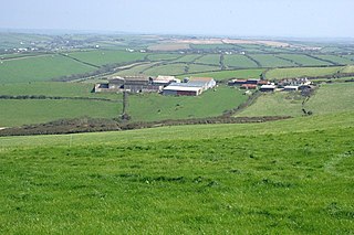
Gooseham is a hamlet in northeast Cornwall, England, United Kingdom. It is situated six miles (11 km) north of Bude and is approximately one kilometre south of the border with Devon. The Marsland Valley nature reserve is near the hamlet. It is in the civil parish of Morwenstow, and its size been described by a resident as consisting of just "two houses and a wood rick."

The De Lank River is a small river in north Cornwall, England. It is a tributary of the River Camel and is approximately nine miles (14.5 km) long from its source on Bodmin Moor to its confluence with the Camel two miles (3 km) south of St Breward.
Coppathorne is a hamlet in the parish of Poundstock, Cornwall, England.

Eastcott is a hamlet 6 miles (9.7 km) north-east of Bude in Cornwall, England. The hamlet is 1 mile (1.6 km) east of Gooseham in the civil parish of Morwenstow and lies within the Cornwall Area of Outstanding Natural Beauty (AONB).
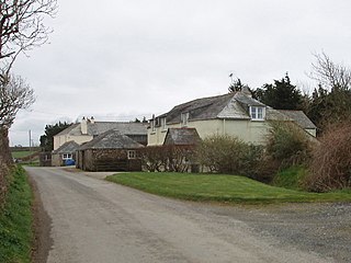
Gooseham Mill is a hamlet in the parish of Morwenstow, Cornwall, England.

Grimscott is a village in north Cornwall, England, UK. It is situated in the civil parish of Launcells, 3 miles (4.8 km) east of the town of Bude.

Helebridge is a hamlet west of Marhamchurch in northeast Cornwall, England.

Hersham is a hamlet south of Kilkhampton in Cornwall, England. Hersham is near Grimscott. It is in the civil parish of Launcells.
Launcells Cross is a hamlet in the parish of Launcells in Cornwall, England. It is on the B3254 road between Grimscott and Red Post.

Lynstone is a hamlet near Bude in north Cornwall, England. At the 2011 census the population at the 2011 census was included in the civil parish of Bude-Stratton.

Northcott is a hamlet in Cornwall, England. Northcott is north of Bude and on the coast close to Northcott Mouth.

Pencuke is a hamlet near Higher Crackington in northeast Cornwall, England, UK.
Pengold is a hamlet near St Gennys in Cornwall, England, UK. Pengold is southwest of Higher Crackington.

Red Post is a crossroads near Launcells in Cornwall, England. It is on the A3072 Holsworthy to Stratton road where it is crossed by the B3254 road.
Rosecare is a hamlet in the parish of St Gennys, Cornwall, England. Rosecare is east of Higher Crackington.
Stibb is a hamlet near Bude in Cornwall, England, United Kingdom.
Lymsworthy Meadows is a Site of Special Scientific Interest (SSSI) in north Cornwall, England, UK, noted for its biological characteristics.

The River Strat is a river in the northernmost part of Cornwall in southwest England. The Strat flows for 12.7 miles to the sea at Bude, having risen to the south of Kilkhampton. It flows initially in a generally southwesterly direction through Stratton to a meeting with its major tributary, the River Neet at Helebridge. The river then turns abruptly to the north-northwest, parallel to the coast which it meets at Bude Haven. The Neet rises to the east of Week St Mary and flow north and northwest to its confluence with the Strat. Other of its tributaries rise to the west of Week St Mary. The section downstream from the vicinity of Helebridge is accompanied by the now disused Bude Canal. The rivers are home to trout, lamprey and eels. The Strat is sometimes also referred to as the River Neet. Older forms of the name of Stratton include Straetneat, one of the meanings of which may be the 'valley of the Neat'.
References
- ↑ Ordnance Survey: Landranger map sheet 190 Bude & Clovelly (Map). Ordnance Survey. ISBN 978-0-319-23145-6.
- ↑ Bush; Explore Britain
| Unitary authorities | |
|---|---|
| Major settlements |
|
| Rivers | |
| Topics | |
Coordinates: 50°50′29″N4°30′39″W / 50.8413465°N 4.51084°W
| | This article about a location in the former district of North Cornwall, England is a stub. You can help Wikipedia by expanding it. |