Buug

Last updated
Buug
Municipality of Buug
Bog festival.jpg
A street dance performance during Bog Festival
Flag of Buug, Zamboanga Sibugay.png
Seal of Buug.png
Ph locator zamboanga sibugay buug.png
Map of Zamboanga Sibugay with Buug highlighted
OpenStreetMap
Buug
Philippines location map (square).svg
Red pog.svg
Buug
Location within the Philippines
Coordinates: 7°43′43″N123°03′39″E / 7.7286°N 123.0608°E / 7.7286; 123.0608
Country Philippines
Region Zamboanga Peninsula
Province Zamboanga Sibugay
District 1st district
Founded February 2, 1960
Barangays 27 (see Barangays)
Government
[1]
  Type Sangguniang Bayan
   Mayor Dionesia B. Lagas
   Vice Mayor Jonam R. Lagas
   Representative Wilter Y. Palma
   Municipal Council
Members
   Electorate 26,069 voters (2022)
Area
[2]
  Total134.06 km2 (51.76 sq mi)
Elevation
174 m (571 ft)
Highest elevation
551 m (1,808 ft)
Lowest elevation
0 m (0 ft)
Population
 (2020 census) [3]
  Total38,425
  Density290/km2 (740/sq mi)
   Households
9,019
Economy
   Income class 3rd municipal income class
   Poverty incidence
24.55
% (2021) [4]
   Revenue 170.7 million (2020)
   Assets 642.2 million (2020)
   Expenditure 150.6 million (2020)
   Liabilities 188.7 million (2020)
Service provider
  ElectricityZamboanga del Sur 2 Electric Cooperative (ZAMSURECO 2)
Time zone UTC+8 (PST)
ZIP code
7009
PSGC
IDD : area code +63(0)62
Native languages Subanon
Cebuano
Chavacano
Tagalog
Website www.buugsibugay.gov.ph

Buug, officially the Municipality of Buug (Cebuano : Lungsod sa Buug; Chavacano: Municipalidad de Buug; Tagalog : Bayan ng Buug), is a 3rd class municipality in the province of Zamboanga Sibugay, Philippines. According to the 2020 census, it has a population of 38,425 people. [3]

Contents

Etymology

The name Buug was derived from the word bog, a Subanen word for secondary forest which is the same as the Cebuano-Visayan term buog. Accordingly, a group of Subanens stumbled upon this bog that was endowed with a stream and sufficient supply of water while they were moving from one place to another in search of a safe place to start a living away from marauders who were in search for slaves and things to loot. From then on people began to refer to the bog as Buug.

History

Buug grew into a thriving community through the initiative of the timuays, the Subanen chieftains, who held leadership of the community. A school was opened which drew in the first trickle of Subanon, Cebuano, and other Visayan settlers. When the Samar Mining Company (SAMICO) opened the Sibuguey project in 1957 at Bobuan (now part of the municipality of Bayog), the next group of settlers flooded in. More people came when the Pagadian-Zamboanga National Highway reached Buug in 1958. The highway is part of the Pan-Philippine Highway (also known as the Maharlika Highway and AH26).

Buug was originally a barangay of the municipality of Margosatubig and became a baranggay of Malangas when the former was divided in 1951. It became a municipality through Executive Order No. 380 issued by President Carlos P. Garcia on February 2, 1960. Instrumental in the formation of the Municipality of Buug was the persistence of Mr. Quirino M. Gonzales, a fisherman who also was a councilor of Malangas and a native of Merida, Leyte. He is also a distant relative of then Senator Neptali Gonzales. Gonzales became the first appointed mayor and was called the "Father of Buug". After being proclaimed as a municipality, flocks of settlers established residence and trade in the place. [5]

Geography

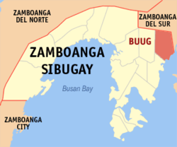
Buug is located in the central Zamboanga Peninsula, on the island of Mindanao. It has a pentagon-like shape bounded on the south by Dumanquilas Bay, Bayog on the north, Kumalarang on the east, Diplahan on the west, and Malangas on south-west. The distance from Manila to Buug is approximately 790 kilometres (490 mi). It is five hours away from Zamboanga City by bus, one hour and 45 minutes bus drive from the Ipil, and 57 kilometres (35 mi) away from Pagadian, or 45 minutes of travel by bus.

Climate

Climate data for Buug, Zamboanga Sibugay
MonthJanFebMarAprMayJunJulAugSepOctNovDecYear
Mean daily maximum °C (°F)30
(86)
30
(86)
31
(88)
31
(88)
29
(84)
28
(82)
28
(82)
28
(82)
28
(82)
28
(82)
29
(84)
29
(84)
29
(84)
Mean daily minimum °C (°F)20
(68)
20
(68)
21
(70)
22
(72)
23
(73)
23
(73)
23
(73)
23
(73)
23
(73)
23
(73)
22
(72)
21
(70)
22
(72)
Average precipitation mm (inches)22
(0.9)
18
(0.7)
23
(0.9)
24
(0.9)
67
(2.6)
120
(4.7)
132
(5.2)
156
(6.1)
119
(4.7)
124
(4.9)
54
(2.1)
24
(0.9)
883
(34.6)
Average rainy days9.49.111.511.920.122.522.423.221.522.215.711.5201
Source: Meteoblue [6] (Use with caution: this is modeled/calculated data, not measured locally.)

It has an average temperature of 26 °C (79 °F) and has an average elevation of 200 metres (660 ft) above sea level. It is away from the typhoon belt and enjoying a Type IV climate, i.e. rainfall is more or less evenly distributed throughout the year.

Barangays

Buug is politically subdivided into 27 barangays. Each barangay consists of puroks while some have sitios.

  • Agutayan
  • Bagong Borbon
  • Basalem
  • Bawang
  • Bliss
  • Bulaan
  • Compostela
  • Danlugan
  • Datu Panas
  • Del Monte
  • Guintuloan
  • Guitom
  • Guminta
  • Labrador
  • Lantawan
  • Mabuhay
  • Maganay
  • Manlin
  • Muyo
  • Pamintayan
  • Pling
  • Poblacion
  • Pulog
  • San Jose
  • Talairan
  • Talamimi
  • Villacastor (Galit)

Demographics

Population census of Buug
YearPop.±% p.a.
1970 22,858    
1975 25,724+2.40%
1980 19,648−5.24%
1990 32,815+5.26%
1995 34,175+0.76%
YearPop.±% p.a.
2000 33,623−0.35%
2007 34,289+0.27%
2010 35,969+1.76%
2015 36,634+0.35%
2020 38,425+0.94%
Source: Philippine Statistics Authority [7] [8] [9] [10]

Economy

Poverty incidence of Buug

10
20
30
40
50
2006
29.60
2009
40.19
2012
30.49
2015
38.90
2018
25.32
2021
24.55

Source: Philippine Statistics Authority [11] [12] [13] [14] [15] [16] [17] [18]

Credit institutions and commercial businesses have multiplied. Appliance centers and merchandisers with main branches in big cities have invested in the area. Cottage industries have also sprouted. Buug's economy is based on two sectors categorized by the local government:

  1. Agriculture which consists of farming, livestock & poultry, and fisheries.
  2. Service Activities such as trade/commerce & industry, finance, personal and community service.

Government

Local government

The local executive council is administered by a mayor. The legislative council is headed by a vice mayor with ten municipal councilors as members, eight of which are elected, plus the representative of Sangguniang Kabataan and the president of the Association of Barangay Captains (ABC).

Congress representation

Buug belongs to the first district of Zamboanga Sibugay. The current representative is Wilter W. Palma II

Education

Buug offers a range of educational options, from primary to tertiary levels, catering to diverse fields of study.

Tertiary Education

Secondary Education

College

Technical and Vocational Education

Related Research Articles

<span class="mw-page-title-main">Zamboanga del Sur</span> Province in Zamboanga Peninsula, Philippines

Zamboanga del Sur, officially the Province of Zamboanga del Sur, is a province in the Philippines located in the Zamboanga Peninsula region in Mindanao. Its capital is the city of Pagadian.

<span class="mw-page-title-main">Zamboanga Sibugay</span> Province in Zamboanga Peninsula, Philippines

Zamboanga Sibugay, officially the Province of Zamboanga Sibugay, is a province in the Philippines located in the Zamboanga Peninsula region in Mindanao. Its capital is Ipil and it borders Zamboanga del Norte to the north, Zamboanga del Sur to the east and Zamboanga City to the southwest. To the south lies Sibuguey Bay in the Moro Gulf.

<span class="mw-page-title-main">Alicia, Zamboanga Sibugay</span> Municipality in The Province of Zamboanga Sibugay, Philippines

Alicia, officially the Municipality of Alicia, is a 3rd class municipality in the province of Zamboanga Sibugay, Philippines. According to the 2020 census, it has a population of 39,456 people.. Alicia is the gateway to Olutanga Island via Guicam Port in Brgy. Guicam where the Guicam Bridge will soon rise.

<span class="mw-page-title-main">Imelda, Zamboanga Sibugay</span> Municipality in Zamboanga Sibugay, Philippines

Imelda, officially the Municipality of Imelda, is a 4th class municipality in the province of Zamboanga Sibugay, Philippines. According to the 2020 census, it has a population of 26,020 people.

<span class="mw-page-title-main">Kabasalan</span> Municipality in Zamboanga Sibugay, Philippines

Kabasalan, officially the Municipality of Kabasalan, is a 2nd class municipality in the province of Zamboanga Sibugay, Philippines. According to the 2020 census, it has a population of 46,884 people.

<span class="mw-page-title-main">Malangas</span> Municipality in Zamboanga Sibugay, Philippines

Malangas, officially the Municipality of Malangas ; Zamboangueño/Chavacano: Municipio de Malangas, is a 3rd class municipality in the province of Zamboanga Sibugay, Philippines. According to the 2020 census, it has a population of 32,022 people.

<span class="mw-page-title-main">Olutanga, Zamboanga Sibugay</span> Municipality in Zamboanga Sibugay, Philippines

Olutanga, officially the Municipality of Olutanga, is a 4th class municipality in the province of Zamboanga Sibugay, Philippines. According to the 2020 census, it has a population of 38,438 people.

<span class="mw-page-title-main">Roseller Lim, Zamboanga Sibugay</span> Municipality in Zamboanga Sibugay, Philippines

Roseller T. Lim, officially the Municipality of Roseller T. Lim, is a 3rd class municipality in the province of Zamboanga Sibugay, Philippines. According to the 2020 census, it has a population of 43,575 people.

<span class="mw-page-title-main">Siay</span> Municipality in Zamboanga Sibugay, Philippines

Siay, officially the Municipality of Siay, is a 2nd class municipality in the province of Zamboanga Sibugay, Philippines. According to the 2020 census, it has a population of 40,585 people.

<span class="mw-page-title-main">Titay</span> Municipality in The Province of Zamboanga Sibugay, Philippines

Titay, officially the Municipality of Titay, is a 2nd class municipality in the province of Zamboanga Sibugay, Philippines. According to the 2020 census, it has a population of 53,994 people.

<span class="mw-page-title-main">La Libertad, Zamboanga del Norte</span> Municipality in Zamboanga del Norte, Philippines

La Libertad, officially the Municipality of La Libertad, is a 5th class municipality in the province of Zamboanga del Norte, Philippines. According to the 2020 census, it has a population of 8,119 people, making it the least populated municipality in the province.

<span class="mw-page-title-main">Tampilisan</span> Municipality in Zamboanga del Norte, Philippines

Tampilisan, officially the Municipality of Tampilisan, is a 4th class municipality in the province of Zamboanga del Norte, Philippines. According to the 2020 census, it has a population of 24,680 people.

<span class="mw-page-title-main">Aurora, Zamboanga del Sur</span> Municipality in Zamboanga del Sur, Philippines

Aurora, officially the Municipality of Aurora, is a 1st class municipality in the province of Zamboanga del Sur, Philippines. According to the 2020 census, it has a population of 52,995 people.

<span class="mw-page-title-main">Dumingag</span> Municipality in Zamboanga del Sur, Philippines

Dumingag, officially the Municipality of Dumingag, is a 2nd class municipality in the province of Zamboanga del Sur, Philippines. According to the 2020 census, it has a population of 48,881 people.

<span class="mw-page-title-main">Guipos</span> Municipality in Zamboanga del Sur, Philippines

Guipos, officially the Municipality of Guipos, is a 4th class municipality in the province of Zamboanga del Sur, Philippines. According to the 2020 census, it has a population of 21,738 people.

<span class="mw-page-title-main">Kumalarang</span> Municipality in Zamboanga del Sur, Philippines

Kumalarang, officially the Municipality of Kumalarang, is a 4th class municipality in the province of Zamboanga del Sur, Philippines. According to the 2020 census, it has a population of 29,479 people.

<span class="mw-page-title-main">Lapuyan</span> Municipality in Zamboanga del Sur, Philippines

Lapuyan, is a 3rd class municipality in the province of Zamboanga del Sur, Philippines. According to the 2020 census, it has a population of 27,737 people. The municipality of Lapuyan is located in the southern section of the Zamboanga del Sur province. It is also often referred to as "Little America".

<span class="mw-page-title-main">Bayog</span> Municipality in Zamboanga del Sur, Philippines

Bayog, officially the Municipality of Bayog, is a 3rd class municipality in the province of Zamboanga del Sur, Philippines. According to the 2020 census, it has a population of 34,519 people.

<span class="mw-page-title-main">Margosatubig</span> Municipality in Zamboanga del Sur, Philippines

Margosatubig, officially the Municipality of Margosatubig, is a 3rd class municipality in the province of Zamboanga del Sur, Philippines. According to the 2020 census, it has a population of 38,660 people.

<span class="mw-page-title-main">Vincenzo A. Sagun</span> Municipality in Zamboanga del Sur, Philippines

Vincenzo A. Sagun, officially the Municipality of Vincenzo A. Sagun, is a 5th class municipality in the province of Zamboanga del Sur, Philippines. According to the 2020 census, it has a population of 24,852 people.

References

  1. Municipality of Buug | (DILG)
  2. "2015 Census of Population, Report No. 3 – Population, Land Area, and Population Density" (PDF). Philippine Statistics Authority. Quezon City, Philippines. August 2016. ISSN   0117-1453. Archived (PDF) from the original on May 25, 2021. Retrieved July 16, 2021.
  3. 1 2 Census of Population (2020). "Region IX (Zamboanga Peninsula)". Total Population by Province, City, Municipality and Barangay. Philippine Statistics Authority . Retrieved 8 July 2021.
  4. "PSA Releases the 2021 City and Municipal Level Poverty Estimates". Philippine Statistics Authority. 2 April 2024. Retrieved 28 April 2024.
  5. Manlin, Alicia. "Municipality of Buug". Municipal Planning and Development Coordinator. Retrieved January 8, 2014.
  6. "Buug: Average Temperatures and Rainfall". Meteoblue. Retrieved 1 May 2020.
  7. Census of Population (2015). "Region IX (Zamboanga Peninsula)". Total Population by Province, City, Municipality and Barangay. Philippine Statistics Authority . Retrieved 20 June 2016.
  8. Census of Population and Housing (2010). "Region IX (Zamboanga Peninsula)" (PDF). Total Population by Province, City, Municipality and Barangay. National Statistics Office . Retrieved 29 June 2016.
  9. Censuses of Population (1903–2007). "Region IX (Zamboanga Peninsula)". Table 1. Population Enumerated in Various Censuses by Province/Highly Urbanized City: 1903 to 2007. National Statistics Office.{{cite encyclopedia}}: CS1 maint: numeric names: authors list (link)
  10. "Province of Zamboanga Sibugay". Municipality Population Data. Local Water Utilities Administration Research Division. Retrieved 17 December 2016.
  11. "Poverty incidence (PI):". Philippine Statistics Authority. Retrieved December 28, 2020.
  12. "Estimation of Local Poverty in the Philippines" (PDF). Philippine Statistics Authority. 29 November 2005.
  13. "2003 City and Municipal Level Poverty Estimates" (PDF). Philippine Statistics Authority. 23 March 2009.
  14. "City and Municipal Level Poverty Estimates; 2006 and 2009" (PDF). Philippine Statistics Authority. 3 August 2012.
  15. "2012 Municipal and City Level Poverty Estimates" (PDF). Philippine Statistics Authority. 31 May 2016.
  16. "Municipal and City Level Small Area Poverty Estimates; 2009, 2012 and 2015". Philippine Statistics Authority. 10 July 2019.
  17. "PSA Releases the 2018 Municipal and City Level Poverty Estimates". Philippine Statistics Authority. 15 December 2021. Retrieved 22 January 2022.
  18. "PSA Releases the 2021 City and Municipal Level Poverty Estimates". Philippine Statistics Authority. 2 April 2024. Retrieved 28 April 2024.